Beaverdam, Ohio facts for kids
Quick facts for kids
Beaverdam, Ohio
|
|
|---|---|
|
Village
|
|

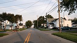
Streetside in Beaverdam
|
|

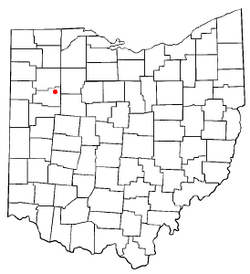
Location of Beaverdam, Ohio
|
|

Location of Beaverdam in Allen County
|
|
| Country | United States |
| State | Ohio |
| County | Allen |
| Township | Richland |
| Area | |
| • Total | 0.63 sq mi (1.63 km2) |
| • Land | 0.63 sq mi (1.63 km2) |
| • Water | 0.00 sq mi (0.00 km2) |
| Elevation | 863 ft (263 m) |
| Population
(2020)
|
|
| • Total | 319 |
| • Estimate
(2023)
|
314 |
| • Density | 506.35/sq mi (195.54/km2) |
| Time zone | UTC-5 (Eastern (EST)) |
| • Summer (DST) | UTC-4 (EDT) |
| ZIP code |
45808
|
| Area code(s) | 419 |
| FIPS code | 39-04752 |
| GNIS feature ID | 2398061 |
| Website | www.beaverdamoh.com |
Beaverdam is a small village located in Richland Township, within Allen County, Ohio, United States. According to the 2020 census, 319 people lived there. Beaverdam is part of the larger Lima Metropolitan Statistical Area.
Contents
Discovering Beaverdam's Past
Beaverdam was first planned out in 1853. The village got its name because there were real beaver dams nearby. A post office opened in 1850, first called "Beaver Dam." Its name changed to "Beaverdam" in 1895. The village officially became a town in 1878.
Where is Beaverdam Located?
Beaverdam is a small village in Ohio. The United States Census Bureau says the village covers about 0.61 square miles (1.63 square kilometers). All of this area is land, with no large bodies of water.
Who Lives in Beaverdam?
| Historical population | |||
|---|---|---|---|
| Census | Pop. | %± | |
| 1880 | 353 | — | |
| 1890 | 397 | 12.5% | |
| 1900 | 477 | 20.2% | |
| 1910 | 455 | −4.6% | |
| 1920 | 394 | −13.4% | |
| 1930 | 360 | −8.6% | |
| 1940 | 377 | 4.7% | |
| 1950 | 450 | 19.4% | |
| 1960 | 514 | 14.2% | |
| 1970 | 525 | 2.1% | |
| 1980 | 492 | −6.3% | |
| 1990 | 467 | −5.1% | |
| 2000 | 356 | −23.8% | |
| 2010 | 382 | 7.3% | |
| 2020 | 319 | −16.5% | |
| 2023 (est.) | 314 | −17.8% | |
| U.S. Decennial Census | |||
The table shows how Beaverdam's population has changed over many years. In 2020, 319 people lived in the village.
Population Details from 2010
In 2010, the census counted 382 people living in Beaverdam. There were 144 households, which means 144 homes where people lived. The village had about 626 people per square mile.
Most of the people living in Beaverdam were White (96.9%). A small number were African American, Native American, or Asian. About 2.1% of residents were from two or more races. About 1.3% of the population identified as Hispanic or Latino.
Many homes had children under 18 (35.4%). Most households (52.1%) were married couples living together. The average household had 2.65 people. The average family had 2.98 people.
The average age of people in Beaverdam was 34.8 years old. About 24.9% of residents were under 18. About 12.6% were 65 years old or older. The village had slightly more males (51.6%) than females (48.4%).
How Transportation Shaped Beaverdam
Beaverdam is located where two old, important highways met. These were the Lincoln Highway and the Dixie Highway, both started in 1914. These roads helped connect different parts of the country.
Today, Beaverdam is known for its three large truck stops. These are located where Interstate 75 and U.S. Route 30 meet. For a long time, US 30 changed from a four-lane highway to a two-lane road right at Beaverdam. This meant cars and trucks had to exit, making the village a popular stop for fuel.
Even though US 30 is now a continuous four-lane highway that goes around Beaverdam, the area is still a major place for vehicles to refuel. In 2006, the exit ramps on I-75 were made wider. This helped handle all the heavy truck and car traffic going to the truck stops.
See also
 In Spanish: Beaverdam (Ohio) para niños
 | May Edward Chinn |
 | Rebecca Cole |
 | Alexa Canady |
 | Dorothy Lavinia Brown |


