Beinn na h-Eaglaise (Graham) facts for kids
Quick facts for kids Beinn na h-Eaglaise |
|
|---|---|

Beinn na h-Eaglaise
|
|
| Highest point | |
| Elevation | 736 m (2,415 ft) |
| Prominence | 305 m (1,001 ft) |
| Listing | Graham, Marilyn |
| Geography | |
| Location | Wester Ross, Scotland |
| Parent range | Northwest Highlands |
| OS grid | NG909523 |
| Topo map | OS Landranger 25 |
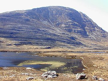
Beinn na h-Eaglaise is a mountain in the Northwest Highlands of Scotland. It stands 736 meters (about 2,415 feet) tall. This mountain is located in an area called Wester Ross, just south of the small village of Torridon.
Exploring Beinn na h-Eaglaise
Beinn na h-Eaglaise is known for its steep slopes. The mountain has a very rocky and rugged side facing the northeast. Many paths used by deer stalkers (people who track deer) go around almost the entire mountain.
Amazing Views from the Top
When you reach the summit, or top, of Beinn na h-Eaglaise, you can see some truly amazing sights. You'll get a great view of its famous neighbors. These include other well-known mountains like Liathach and Maol Cheann-dearg. These are both "Munros," which are Scottish mountains over 3,000 feet (914.4 meters) high.
What Kind of Mountain Is It?
Beinn na h-Eaglaise is classified as both a "Graham" and a "Marilyn."
- A Graham is a Scottish mountain between 2,000 and 2,500 feet (609.6 and 762 meters) high. It must also have a drop of at least 150 meters (about 492 feet) on all sides.
- A Marilyn is a hill or mountain of any height in the British Isles. It must have a drop of at least 150 meters (about 492 feet) on all sides.

