
Maol Cheann-dearg facts for kids
Quick facts for kids Maol Cheann-dearg |
|
|---|---|

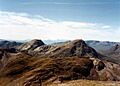
Maol Cheann-dearg (right) and An Ruadh-stac (left) from Beinn Liath Mhòr with Beinn Bhàn and the Skye Cuillin in the background .
|
|
| Highest point | |
| Elevation | 933 m (3,061 ft) |
| Prominence | c. 375 m |
| Listing | Munro, Marilyn |
| Naming | |
| English translation | Bald Red Head |
| Language of name | Gaelic |
| Geography | |
| Location | Wester Ross, Scotland |
| Parent range | Northwest Highlands |
| OS grid | NG924499 |
| Topo map | OS Landranger 25 |
Maol Cheann-dearg (which means Bald Red Head in Gaelic) is a mountain in Scotland. It stands tall between two large lakes, Loch Torridon and Loch Carron, in an area called Wester Ross. This region is known for its beautiful, wild landscapes.
Maol Cheann-dearg is one of three special mountains in this area called Munros. A Munro is a Scottish mountain that is over 3,000 feet (914.4 meters) high. Maol Cheann-dearg reaches 933 meters (3,060 feet) into the sky. It's a bit separate from its two Munro neighbours, Sgorr Ruadh and Beinn Liath Mhòr, by a lower section of land. This means people often climb it on its own.
The mountain's sides are steep and covered in rocks. Its top looks like a dome and is full of red sandstone boulders, with very little plant life. This makes its name, "Bald Red Head," a perfect description! Be careful not to mix it up with Maol Chinn-dearg, which is another Munro found on a different ridge.
Climbing Maol Cheann-dearg
Maol Cheann-dearg is special because it has good paths all around it. These paths were originally made for gamekeepers on the Beinn Damh deer estate. You can use them to walk all the way around the mountain. This walk lets you see amazing sandstone cliffs and pretty lakes like Loch an Eion and Loch Coire Fionnaraich. These lakes are also home to interesting wild birds.
If you are a very strong walker, you might even climb Maol Cheann-dearg along with a nearby mountain called An Ruadh-stac. An Ruadh-stac is 892 meters high and is known as a Corbett. A Corbett is another type of Scottish mountain, slightly smaller than a Munro.
Starting Your Climb
Most people start their climb of Maol Cheann-dearg from a place called Coulags. This is on the A890 road in Glen Carron, where you can park your car. You follow a valley called Fionn-amhainn as you head north.
Along the way, you will pass a small building called a bothy at Coire Fionnaraich. A bothy is a basic shelter that hikers can use for free. This one is quite nice and even has a single ash tree outside its front door.
About 500 meters further on, you will see a strange standing stone. This is called the Clach nan Con-fionn, which means "The Stone of Fingal’s Dog." Legend says that Fionn mac Cumhaill, a famous giant from Irish myths, tied his hunting dogs here!
Another 500 meters after the stone, a path turns west. This path leads you up to a high point called Bealach a' Choire Ghairbh. From there, you follow the south-east ridge. The path here can be tricky, with broken quartzite rocks and large boulders.
The Summit View
When you reach the top of Maol Cheann-dearg, you'll find a very large pile of stones called a cairn. The view from here is amazing! Many people say it's one of the best views from any Munro. You can clearly see the Torridon Hills to the west. You can also spot Beinn Bhàn and the Skye Cuillin mountains in the distance to the south-west.

Images for kids
-
Maol Cheann-dearg (right) and An Ruadh-stac (left) from Beinn Liath Mhòr with Beinn Bhàn and the Skye Cuillin in the background .
