An Ruadh-stac facts for kids
Quick facts for kids An Ruadh-stac |
|
|---|---|

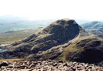
The north face of An Ruadh-stac seen from Maol Cheann-dearg.
|
|
| Highest point | |
| Elevation | 892 m (2,927 ft) |
| Prominence | 334 m (1,096 ft) |
| Listing | Corbett, Marilyn |
| Naming | |
| English translation | Red Stack /Red Conical Hill |
| Language of name | Gaelic |
| Geography | |
| Parent range | Northwest Highlands |
| OS grid | NG921480 |
| Topo map | OS Landranger 24, OS Explorer 428 |

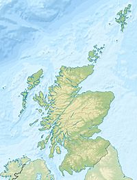
An Ruadh-stac is a cool mountain in Scotland. You can find it in the Wester Ross area of the Highland council. It's about 26 km (16 miles) northeast of Kyle of Lochalsh.
Contents
Discover An Ruadh-stac: A Scottish Mountain
An Ruadh-stac stands tall at 892 metres (2,926 feet) high. This makes it the 30th highest Corbett mountain in Scotland. It's also known as a Marilyn, which is another type of hill based on how high it rises from the land around it.
This mountain looks very special. It stands out because of its light grey rocks, which are made of quartzite. An Ruadh-stac is part of the old Coulin hunting forest. This area is a wild, mountainous place between Glen Carron and Glen Torridon.
Even though the mountain is about four kilometres from the nearest main road, it's not too hard to reach. There are good paths that help people get to the base of the mountain. An Ruadh-stac is often climbed along with its nearby mountain, Maol Cheann-dearg.
What Does "An Ruadh-stac" Mean?
The mountain's name comes from the Gaelic language. It means "Red Stack" or "Red Conical Hill." This can be a bit confusing! Most people see it as a light-grey mountain because of its quartzite rocks.
A famous Scottish climber, Hamish Brown, once said that An Ruadh-stac is a grey hill. He noted that it sometimes looks white when the sun hits it, but it's never red like its neighbour, Maol Cheann-dearg.
Exploring the Shape of An Ruadh-stac
An Ruadh-stac has a classic triangle shape, formed by three steep ridges. The northeast ridge is the least steep. This is usually the path that walkers use to go up and down the mountain. This ridge goes down to a 600-metre-high (2,000 ft) mountain pass called Bealach a’ Choire Ghairbh. This pass connects An Ruadh-stac to Maol Cheann-dearg, which is about two kilometres north.
The south ridge leads over a smaller peak called Ruadh Stac Beag, which is 758 metres high. From there, it goes down towards Glen Carron. The north and west sides of the mountain have very steep cliffs. This means the northwest ridge is too dangerous for most walkers.
Amazing Rock Features and Glacial History
The most impressive part of the mountain is its north face. This is a very steep rock wall that shows off the mountain's layers of rock when you see it from far away. These cliffs rise over 400 metres from the edge of Loch Coire an Ruaidh-staic.
These cliffs are popular with rock climbers. Famous climbers like Tom Patey and Chris Bonington were among the first to climb a 180-metre-long (590 ft) route here in 1960.
The lower slopes on the southeast side of the mountain have smooth, ice-polished rocks. You can also see long, flowing mounds of rocky debris. These are called fluted moraine, which were left behind by a glacier. These mounds are less than four metres high but can be up to 400 metres long!
Beautiful Lochs Around the Mountain
An Ruadh-stac also has four small lochs (lakes) around its northeast side. Each loch is at a different height, adding to the mountain's beauty.
One of these lochs, Loch a’ Mhadaidh Ruadh, is considered one of the most beautiful in the Scottish Highlands. It's located on the Bealach a’ Choire Ghairbh pass. It's surrounded by walls of quartzite rock, which makes it look almost man-made.
All the water from the mountain flows west towards the coast of Scotland. It either goes directly to Upper Loch Torridon or southeast to Glen Carron and then to Loch Carron.
Climbing An Ruadh-stac and What You See from the Top
The summit of An Ruadh-stac is quite a distance from any road. The closest place to start your climb is on the A890 road at Coulags in Glen Carron. You can find this spot at grid reference NG958451.
From here, you follow a footpath north up the valley of the Fionn-abhainn river. Then you cross the river and head west, climbing up to the Bealach a’ Choire Ghairbh. From this pass, it's a challenging 340-metre climb. You'll go over rough slopes of loose rocks (called scree) and flat, slabby rocks to reach the top.
You can also climb the mountain using a longer route from Glen Torridon. This path starts from Annat at NG893544.
Views from the Summit
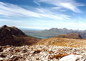
The top of An Ruadh-stac is covered with quartzite boulders. The highest point is marked by a pile of rocks called a cairn. From here, you get amazing views!
You can see the Skye Cuillin mountains to the southwest. Upper Loch Torridon appears next to Beinn Damh to the northwest. The other Torridon hills are further around to the north. If you explore the summit area, you can even look 1000 feet down the cliffs of the north face to Loch Coire an Ruaidh-staic.
 | Jessica Watkins |
 | Robert Henry Lawrence Jr. |
 | Mae Jemison |
 | Sian Proctor |
 | Guion Bluford |


