
Beinn Damh facts for kids
Quick facts for kids Beinn Damh |
|
|---|---|

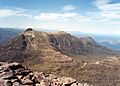
The rough eastern side of Beinn Damh seen from Maol Cheann-dearg.
|
|
| Highest point | |
| Elevation | 903 m (2,963 ft) |
| Prominence | 518 m (1,699 ft) |
| Listing | Corbett, Marilyn |
| Naming | |
| English translation | Hill of the Stag |
| Language of name | Gaelic |
| Geography | |
|
Lua error in Module:Location_map at line 420: attempt to index field 'wikibase' (a nil value).
|
|
| Parent range | Northwest Highlands |
| OS grid | NG892501 |
| Topo map | OS Landranger 24 |
Beinn Damh (also called Ben Damph) is a mountain in Scotland. It is found in a wild, rocky area between Upper Loch Torridon and Glen Carron. This is about 25 kilometres north of Kyle of Lochalsh.
Beinn Damh is known as a Corbett. A Corbett is a Scottish mountain between 762 and 914 metres (2,500 and 3,000 feet) high. Beinn Damh stands at 903 metres (2,962 feet) tall. It is just 11 metres short of being a Munro, which is a mountain over 914 metres. Even so, it is a very impressive mountain. It has a long, wavy top ridge that stretches for four kilometres. This ridge has three main peaks. The mountain also has very steep sides and rocky cliffs. Its eastern side is especially dramatic, with huge rock formations.
One cool feature of Beinn Damh is the "Stirrup Mark." This is a noticeable, semi-circular area of white quartzite rock. It is surrounded by darker grey rock. You can see it clearly on the mountain's south-west side. The name "Beinn Damh" means "Hill of the Stag" in Gaelic. This name fits well because the mountain is in the middle of the Ben Damh deer estate.
Contents
Climbing Beinn Damh
Climbing Beinn Damh is an exciting adventure. Most people start their journey from the Loch Torridon Hotel. This hotel is in Torridon village, located on the A896 road.
Starting the Climb
The path begins by following a stream called Allt Coire Roill. After walking for just over a kilometre, you will pass a waterfall that is about 30 metres (98 feet) high. Here, the path splits into two different routes.
Choosing Your Path
- The right path is an easier way to reach the top ridge. It climbs up through a corrie called Toll Bàn. A corrie is a bowl-shaped hollow in the mountain.
- The left path continues further up the glen. It leads to a small loch (a small lake) at the top of the valley. This route then climbs up the steep north-eastern ridge. This path goes around a difficult eastern rock face. It involves some tricky scrambling, where you might need to use your hands to climb over rocks. This path takes you directly to the highest point.
Exploring the Summit
Many climbers like to use both routes. They might go up one way and come down the other. This allows them to explore more of the mountain. You can also take a side trip to climb Sgurr na Bana Mhoraire. This is a northern peak that is 687 metres (2,254 feet) high. It offers amazing views over Loch Torridon.
The very highest point of Beinn Damh is at the southern end of its top ridge. From here, you can see fantastic views of other famous mountains. These include Beinn Alligin, Liathach, and the Applecross hills. You can also see the Munros and Corbetts in the Glen Carron area.
Images for kids
-
The rough eastern side of Beinn Damh seen from Maol Chean-dearg.
