Sgorr Ruadh facts for kids
Quick facts for kids Sgorr Ruadh |
|
|---|---|

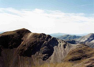
Sgorr Ruadh seen from Beinn Liath Mhòr
|
|
| Highest point | |
| Elevation | 962 m (3,156 ft) |
| Prominence | 727 m (2,385 ft) |
| Parent peak | Sgurr Mor |
| Listing | Munro, Marilyn |
| Naming | |
| English translation | Red Peak |
| Language of name | Gaelic |
| Geography | |
| Location | Wester Ross, Scotland |
| Parent range | Northwest Highlands |
| OS grid | NG959505 |
| Topo map | OS Landranger 25 |
Sgorr Ruadh is a cool mountain found in the Highland Region of Scotland. It's located in an area called Wester Ross, between Strath Carron and Glen Torridon. This mountain is close to Achnashellach, and it's often climbed with its neighbors, Beinn Liath Mhòr and Fuar Tholl.
Contents
What is Sgorr Ruadh?
Sgorr Ruadh is a very appealing mountain. It stands 962 metres (3,156 feet) tall. Because of its height, it is known as a Munro. This means it's one of Scotland's highest mountains.
Why is it called Red Peak?
The mountain is made of red sandstone. This gives it a reddish color. Its name, Sgorr Ruadh, actually means "Red Peak" in Gaelic.
How does it look?
Sgorr Ruadh looks a lot like the famous Torridon Hills nearby. It has steep, step-like cliffs and lots of loose rock slopes. The northwest side has very steep cliffs. These are usually avoided by hikers. However, these cliffs are popular with rock climbers. They offer about 20 different climbing routes.
How to Climb Sgorr Ruadh
Most people start their climb of Sgorr Ruadh from Achnashellach. This village is in Glen Carron. You can also start from Glen Torridon. But this route is much longer and tougher.
Starting from Achnashellach
From Achnashellach, you follow a path. This path is a right of way that goes up Coire Lair towards Torridon. After about two kilometers, you'll see a pile of stones, called a cairn. This cairn shows where a path turns left.
Crossing the River and Reaching the Pass
The path crosses the River Lair. Sometimes, you might need to wade through the water. After crossing, the path climbs up to the top of the Bhealaich Mhoir. This is a mountain pass. It sits between Sgorr Ruadh and Fuar Tholl.
The Final Climb to the Top
From the top of this pass, it's a 275-meter climb to the summit. You'll need to carefully go around the many rocky cliffs and gullies.
Views from the Summit
At the very top, there's a cairn (a pile of stones). It's in an amazing spot right on the edge of steep slopes. From here, you get incredible views all around. You can clearly see the two nearby Munros: Beinn Liath Mhòr and Maol Chean-dearg. The stunning Torridon mountains are also visible to the west.
Continuing to Beinn Liath Mhòr
Many hikers like to continue their adventure. After climbing Sgorr Ruadh, they often head to the nearby Munro, Beinn Liath Mhòr. This part of the hike is not easy. There are rocky areas and tall rock steps. These are found at the bottom of the pass between the two mountains.
 | Kyle Baker |
 | Joseph Yoakum |
 | Laura Wheeler Waring |
 | Henry Ossawa Tanner |

