Bells, Tennessee facts for kids
Quick facts for kids
Bells, Tennessee
|
|
|---|---|

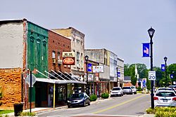
Main Street in Bells
|
|

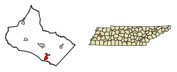
Location of Bells in Crockett County, Tennessee.
|
|
| Country | United States |
| State | Tennessee |
| County | Crockett |
| Area | |
| • Total | 2.38 sq mi (6.16 km2) |
| • Land | 2.37 sq mi (6.14 km2) |
| • Water | 0.01 sq mi (0.02 km2) |
| Elevation | 325 ft (99 m) |
| Population
(2020)
|
|
| • Total | 2,463 |
| • Density | 1,038.80/sq mi (401.09/km2) |
| Time zone | UTC-6 (Central (CST)) |
| • Summer (DST) | UTC-5 (CDT) |
| ZIP code |
38006
|
| Area code(s) | 731 |
| FIPS code | 47-04720 |
| GNIS feature ID | 1305093 |
Bells is a small city located in Crockett County, Tennessee. In 2020, about 2,463 people lived there.
Contents
History of Bells
Bells started in the late 1820s. Two brothers, John and William Bell, bought the land. A city was officially founded on this land in 1855. It was first called "Bells Depot."
The city became an official town in 1868. Later, in 1880, the word "Depot" was removed from its name. So, it became simply "Bells."
For a while, Bells was home to the West Tennessee Okra Festival. This fun festival had a horse show and a beauty pageant. There was also a street carnival with many activities. The festival always took place in August. This was when okra, a popular vegetable, was ready to harvest.
Geography of Bells
Bells is located in western Tennessee. You can find it at coordinates 35°43′6″N 89°5′7″W. The city is mainly found where two major roads meet. These roads are U.S. Route 70A and U.S. Route 79. They connect Bells to nearby towns like Brownsville and Humboldt.
Another important road is Tennessee State Route 88. This route links Bells to Alamo and Jackson. The South Fork of the Forked Deer River flows just south of the city.
According to the United States Census Bureau, Bells covers a total area of about 2.3 square miles (6.16 square kilometers). Most of this area is land. Only a very small part, about 0.44%, is water.
Bells Population and People
| Historical population | |||
|---|---|---|---|
| Census | Pop. | %± | |
| 1880 | 540 | — | |
| 1890 | 690 | 27.8% | |
| 1900 | 758 | 9.9% | |
| 1910 | 753 | −0.7% | |
| 1920 | 920 | 22.2% | |
| 1930 | 919 | −0.1% | |
| 1940 | 1,054 | 14.7% | |
| 1950 | 1,225 | 16.2% | |
| 1960 | 1,232 | 0.6% | |
| 1970 | 1,474 | 19.6% | |
| 1980 | 1,571 | 6.6% | |
| 1990 | 1,643 | 4.6% | |
| 2000 | 2,171 | 32.1% | |
| 2010 | 2,437 | 12.3% | |
| 2020 | 2,463 | 1.1% | |
| Sources: | |||
2020 Census Information
| Group | Number of People | Percentage |
|---|---|---|
| White (not Hispanic) | 1,290 | 52.38% |
| Black or African American (not Hispanic) | 588 | 23.87% |
| Native American | 1 | 0.04% |
| Asian | 14 | 0.57% |
| Other/Mixed | 109 | 4.43% |
| Hispanic or Latino | 461 | 18.72% |
As of the 2020 United States census, 2,463 people lived in Bells. There were 917 households and 640 families. This means many different people and families call Bells home.
Economy and Businesses in Bells
Bells is home to the main office of PictSweet Farms. This company sells frozen vegetables. They are known across the United States. The Tankersley family has owned and managed PictSweet for three generations.
PictSweet Farms is a very important employer in the Bells area. They provide many jobs for the people living there.
See also
 In Spanish: Bells (Tennessee) para niños
 | Precious Adams |
 | Lauren Anderson |
 | Janet Collins |

