Ben Lomond, California facts for kids
Quick facts for kids
Ben Lomond
|
|
|---|---|

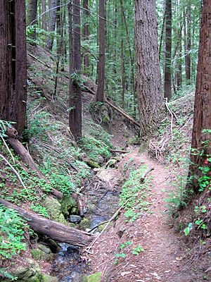
Marshall Creek, at The Quaker Center in Ben Lomond
|
|

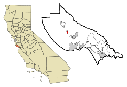
Location in Santa Cruz County and the state of California
|
|
| Country | United States |
| State | California |
| County | Santa Cruz |
| Area | |
| • Total | 8.37 sq mi (21.67 km2) |
| • Land | 8.37 sq mi (21.67 km2) |
| • Water | 0.00 sq mi (0.00 km2) 0% |
| Elevation | 331 ft (101 m) |
| Population
(2020)
|
|
| • Total | 6,337 |
| • Density | 757.20/sq mi (292.37/km2) |
| Time zone | UTC−8 (PST) |
| • Summer (DST) | UTC−7 (PDT) |
| ZIP Code |
95005
|
| Area code(s) | 831 |
| FIPS code | 06-05332 |
| GNIS feature ID | 1655826 |
Ben Lomond is a community in Santa Cruz County, California, United States. It's also the name of a mountain nearby. This community is a "census-designated place" (CDP), which means it's a specific area counted by the census. In 2020, about 6,337 people lived here. The area includes smaller communities called Glen Arbor and Brackney.
Contents
History of Ben Lomond
The mountain near Ben Lomond was named by John Burns, a man from Scotland. He settled there in 1851 and named it after a mountain in his home country, Ben Lomond in Scotland. John Burns was one of the first people to grow grapes for wine in the Santa Cruz Mountains. He is also thought to have named the community of Bonny Doon.
The area around the San Lorenzo River had many Coast redwood trees. Because of this, it became an important place for the logging and lumber industry in Santa Cruz County. The community was first called Pacific Mills, named after a sawmill there. In 1887, when the community wanted to open a U.S. Post Office, people voted to use the name of the mountain, Ben Lomond.
The Alba School was a one-room schoolhouse built in 1895. It was used as a school until 1940. Later, it became a library and a community center. Sadly, it was destroyed by the CZU Lightning Complex fires in August 2020.
Geography of Ben Lomond
Ben Lomond is located on State Highway 9. It's about 12 miles (19 km) from Santa Cruz and 34 miles (55 km) from San Jose, which is the closest big city. The community covers an area of about 8.4 square miles (21.8 square kilometers).
The San Lorenzo River flows through Ben Lomond. This area is known as the San Lorenzo Valley. To the east of the community is Ben Lomond Mountain. This mountain is actually a long ridge, and its highest point is about 2,660 feet (811 m) high.
Northeast of Ben Lomond, you'll find Loch Lomond. This is a reservoir, which is like a large lake that stores water. It was built on Newell Creek and is also named after the original Loch Lomond in Scotland.
Climate
Ben Lomond has weather records going back to 1937. The area usually gets about 49.63 inches (1,261 mm) of rain each year. Snowfall is very rare, with an average of only 0.1 inches (0.3 cm) per year.
Because of the surrounding mountains, summers in Ben Lomond can get quite warm. Even though it's near the ocean, summer temperatures often reach around 90°F (32°C) and can sometimes go over 100°F (38°C). In winter, it can get colder at night than in nearby areas. This is because of the higher elevation and less influence from the ocean, leading to more frosty nights.
The hottest temperature ever recorded was 121°F (49°C) on September 6, 2020. The coldest temperature was 15°F (-9°C) on December 22, 1990. On average, there are about 53 days each year when the temperature reaches 90°F (32°C) or higher. There are also about 36 days when the temperature drops to 32°F (0°C) or lower.
The year with the most rain was 1983, with 100.37 inches (2,549 mm). The driest year was 2013, with only 7.71 inches (196 mm). The most rain in one month was 35.77 inches (908.6 mm) in December 1955. The most rain in just 24 hours was 11.47 inches (291 mm) on January 4, 1982. On average, it rains about 76 days a year. The most snow in 24 hours was 2.0 inches (5.1 cm) on January 21, 1962.
| Climate data for Ben Lomond, California, 1991–2020 normals, extremes 1937–present | |||||||||||||
|---|---|---|---|---|---|---|---|---|---|---|---|---|---|
| Month | Jan | Feb | Mar | Apr | May | Jun | Jul | Aug | Sep | Oct | Nov | Dec | Year |
| Record high °F (°C) | 87 (31) |
91 (33) |
94 (34) |
100 (38) |
106 (41) |
113 (45) |
113 (45) |
113 (45) |
121 (49) |
112 (44) |
96 (36) |
85 (29) |
121 (49) |
| Mean maximum °F (°C) | 75.6 (24.2) |
79.2 (26.2) |
84.2 (29.0) |
91.3 (32.9) |
94.3 (34.6) |
100.1 (37.8) |
101.9 (38.8) |
102.7 (39.3) |
103.8 (39.9) |
97.9 (36.6) |
86.1 (30.1) |
74.1 (23.4) |
107.5 (41.9) |
| Mean daily maximum °F (°C) | 64.6 (18.1) |
66.9 (19.4) |
70.6 (21.4) |
75.0 (23.9) |
79.6 (26.4) |
85.5 (29.7) |
87.9 (31.1) |
89.5 (31.9) |
88.6 (31.4) |
83.0 (28.3) |
71.3 (21.8) |
63.7 (17.6) |
77.2 (25.1) |
| Daily mean °F (°C) | 51.0 (10.6) |
52.9 (11.6) |
55.6 (13.1) |
58.5 (14.7) |
62.6 (17.0) |
67.1 (19.5) |
69.6 (20.9) |
70.2 (21.2) |
68.7 (20.4) |
63.6 (17.6) |
55.4 (13.0) |
50.2 (10.1) |
60.4 (15.8) |
| Mean daily minimum °F (°C) | 37.4 (3.0) |
38.9 (3.8) |
40.5 (4.7) |
41.9 (5.5) |
45.7 (7.6) |
48.6 (9.2) |
51.2 (10.7) |
51.0 (10.6) |
48.9 (9.4) |
44.2 (6.8) |
39.6 (4.2) |
36.8 (2.7) |
43.7 (6.5) |
| Mean minimum °F (°C) | 26.6 (−3.0) |
28.3 (−2.1) |
30.2 (−1.0) |
32.5 (0.3) |
36.8 (2.7) |
39.9 (4.4) |
43.8 (6.6) |
42.9 (6.1) |
39.5 (4.2) |
34.0 (1.1) |
29.1 (−1.6) |
25.9 (−3.4) |
24.3 (−4.3) |
| Record low °F (°C) | 18 (−8) |
20 (−7) |
25 (−4) |
25 (−4) |
29 (−2) |
31 (−1) |
39 (4) |
31 (−1) |
28 (−2) |
26 (−3) |
25 (−4) |
15 (−9) |
15 (−9) |
| Average precipitation inches (mm) | 10.42 (265) |
9.68 (246) |
7.00 (178) |
3.28 (83) |
1.24 (31) |
0.24 (6.1) |
0.01 (0.25) |
0.04 (1.0) |
0.12 (3.0) |
2.17 (55) |
5.00 (127) |
10.43 (265) |
49.63 (1,261) |
| Average snowfall inches (cm) | 0.0 (0.0) |
0.1 (0.25) |
0.0 (0.0) |
0.0 (0.0) |
0.0 (0.0) |
0.0 (0.0) |
0.0 (0.0) |
0.0 (0.0) |
0.0 (0.0) |
0.0 (0.0) |
0.0 (0.0) |
0.0 (0.0) |
0.1 (0.25) |
| Average precipitation days (≥ 0.01 in) | 12.2 | 12.1 | 10.0 | 6.8 | 4.1 | 1.5 | 0.3 | 0.6 | 1.1 | 3.6 | 7.6 | 12.3 | 72.2 |
| Average snowy days (≥ 0.1 in) | 0.0 | 0.1 | 0.0 | 0.0 | 0.0 | 0.0 | 0.0 | 0.0 | 0.0 | 0.0 | 0.0 | 0.0 | 0.1 |
| Source 1: NOAA | |||||||||||||
| Source 2: National Weather Service | |||||||||||||
Population Data
| Historical population | |||
|---|---|---|---|
| Census | Pop. | %± | |
| 2020 | 6,337 | — | |
| U.S. Decennial Census 1850–1870 1880-1890 1900 1910 1920 1930 1940 1950 1960 1970 1980 1990 2000 2010 |
|||
2010 Census
In 2010, Ben Lomond had a population of 6,234 people. Most of the people living there were White (91.3%). There were also smaller groups of African American, Native American, Asian, and Pacific Islander residents. About 8.3% of the population was Hispanic or Latino.
The community has people of all ages. In 2010, about 19.5% of the population was under 18 years old. About 10.2% were 65 years or older.
Local Businesses
Love Creek is a business located on the east side of Ben Lomond's main business area, along Highway 9.
Transportation
You can get around Ben Lomond using the Santa Cruz Metro Transit Bus. Route 35 and 35E both go through the community.
Notable People
- Guillermo Wagner Granizo (1923–1995) was an artist who created ceramic tile murals. He lived in Ben Lomond from the 1970s until 1980.
- Jim Jeffries (1875–1953) was a famous boxer. In the 1940s, he trained at the Wagon Wheel Bar and Restaurant, which is no longer there.
See also
 In Spanish: Ben Lomond (California) para niños
 | Kyle Baker |
 | Joseph Yoakum |
 | Laura Wheeler Waring |
 | Henry Ossawa Tanner |


