
San Lorenzo River facts for kids
Quick facts for kids San Lorenzo River |
|
|---|---|

The San Lorenzo River southeast of downtown Santa Cruz.
|
|
| Other name(s) | Rio de San Lorenzo |
| Country | United States |
| State | California |
| Region | Santa Cruz County |
| Cities | Boulder Creek, Ben Lomond, Felton, Santa Cruz |
| Physical characteristics | |
| Main source | in the Santa Cruz Mountains Castle Rock State Park 2,670 ft (810 m) 37°15′15″N 122°07′10″W / 37.25417°N 122.11944°W |
| River mouth | Monterey Bay Santa Cruz, California 0 ft (0 m) 36°57′51″N 122°00′45″W / 36.96417°N 122.01250°W |
| Length | 47.2 km |
| Basin features | |
| Tributaries |
|

The San Lorenzo River is a river in California, about 29.3 miles (47.2 km) long. It starts high up in the Santa Cruz Mountains at Castle Rock State Park. From there, it flows south through the San Lorenzo Valley. Finally, it passes through the city of Santa Cruz and empties into Monterey Bay and the Pacific Ocean.
Contents
History of the San Lorenzo River
How the River Got Its Name
The San Lorenzo River got its name from the first European explorers in Alta California. This was the Spanish Portolà expedition in 1769. They camped near the river on October 17. A missionary named Juan Crespi was with them. He wrote in his diary that they found a "large river" near the sea. They named it San Lorenzo. This spot was likely where the first bridges were later built.
The California Powder Works
In 1863, a factory called the California Powder Works was built next to the river. It was about three miles upstream from Santa Cruz. This factory made gunpowder for mining in California. This was important because the American Civil War had stopped normal supplies.
To power the factory, a dam was built upstream. This dam raised the water level. Water then flowed into a long tunnel and a flume. This system provided water power for the factory machines. Sometimes, when the river was low in summer, almost all the water went into the flume. The factory closed in 1914, and the dam was taken down.
River Life: Fish and Ecology
Fish Populations and Conservation
The San Lorenzo River was once a very popular home for steelhead trout (Oncorhynchus mykiss) and coho salmon (Oncorhynchus kisutch). These fish are important to the Central Coast of California. About 26 miles (42 km) of the river and at least nine of its smaller streams support steelhead.
Historically, the San Lorenzo River had the largest coho salmon and steelhead fishing area south of San Francisco Bay. It was also the fourth largest steelhead fishing area in California. In 1960, there were more than 30,000 fish in the river. But ten years later, the number dropped to only 1,000.
Rules for fishing were changed in 1998 to protect wild fish. However, more efforts are still needed. Coho salmon in the San Lorenzo River are now listed as endangered. Steelhead are listed as threatened under the federal Endangered Species Act. This means they are at risk of disappearing.
Return of Coho Salmon
By 1995, coho salmon were found in only a few places south of San Francisco Bay. There was a small group in Waddell Creek and another in Scott Creek. The San Lorenzo River had a small group of non-native coho that were kept alive by a hatchery.
Historically, coho lived in about 50 coastal streams. But by the 1960s, they were only in 11 stream systems. The number of coho in Waddell and Scott Creeks in 1995 was very low. There were no coho in the San Lorenzo River at that time.
Coho have started to return thanks to efforts at the Kingfisher Flat Hatchery. This hatchery is on a stream called Big Creek, which flows into Scott Creek. Coho salmon had not been seen in the San Lorenzo River since the early 1980s. But in 2005, at least a dozen adult coho were seen at a fish ladder in Santa Cruz.
Other Fish Species
Old records from 1915 show that other types of salmon also used the San Lorenzo River. These included chinook salmon (Oncorhynchus tshawytscha) and pink salmon (Oncorhynchus gorbuscha). Sometimes, chum salmon (Oncorhynchus keta) were also found.
The River's Path and Watershed
Understanding the Watershed
The San Lorenzo River watershed is the area of land where all water drains into the river. This watershed covers about 138 square miles (357 square kilometers). Branciforte Creek is a large stream that flows into the San Lorenzo River.
Newell Creek is another important stream. It was dammed to create Loch Lomond. This reservoir provides drinking water for the city of Santa Cruz.
Challenges: Flooding and Pollution
Flood Control Efforts
In December 1955, the San Lorenzo River had very bad floods. Because of this, the Army Corps of Engineers built flood control structures. These included levees and floodwalls along the river in downtown Santa Cruz.
In January 1982, there was another large flood event. The river did not flood over its banks, but the water levels were much higher than expected. This was because a lot of sand and dirt had built up in the river channel. The original plan for flood control required regularly digging out this sediment. This process is called dredging. Dredging is expensive and can harm river habitats.
The levees and floodwalls were rebuilt in 2004. The new design still assumed some dredging would happen. However, any dredging is difficult for the City of Santa Cruz. The Army Corps of Engineers has been studying how well the flood control works without regular dredging.
Water Pollution Issues
Pollution is another problem for the river and its wildlife. Water pollution comes from the city of Santa Cruz and other towns upstream. These towns include Felton, Ben Lomond, Brookdale, and Boulder Creek.
Many homes in the San Lorenzo River watershed use septic systems. These systems treat wastewater from homes. In the 1980s, many septic systems were not working correctly. This caused untreated sewage to leak into the ground. Also, some households were illegally discharging greywater, which is water from sinks and showers. This water also has high levels of bacteria.
Even with improvements, bacteria levels in some areas of the river are still high. They barely meet the standards for safe swimming. Nitrate levels are also very high. This is a threat to the drinking water supply for much of the county. Scientists have used mathematical models to study how pollution moves in the river. These models help plan ways to manage land and control floods.
The River's Beauty
Scenic Views and Pathways
The upper parts of the San Lorenzo River watershed are very beautiful. They are surrounded by natural forests. The lower part of the river is easy for people in Santa Cruz to visit.
In 1987, the city of Santa Cruz created a plan to connect the river's natural beauty with the city's design. This plan led to new walking paths, picnic areas, and places to enjoy the views along the river. The plan also aimed to create a continuous forest along the riverbanks. This forest would include trees like Valley Oak, Buckeye, and Willow.
One very scenic part of the river is between the Riverside Avenue and Broadway bridges. Here, the river curves around Beach Hill. This is a historic area and an important part of Santa Cruz's landscape. This part of the river can be seen from many places in the city. It makes the river channel look steep and enclosed. The west bank used to have a wooden boardwalk, but it has been washed away by erosion.
Images for kids
-
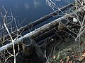
The eroded remains of the original San Lorenzo River Boardwalk.

