Bennington, Nebraska facts for kids
Quick facts for kids
Bennington, Nebraska
|
||
|---|---|---|

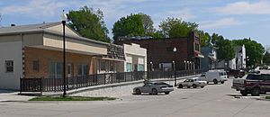
Downtown Bennington: 2nd Street, April 2012
|
||
|
||

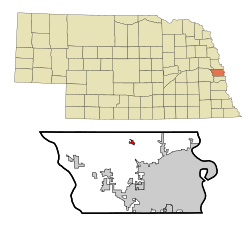
Location of Bennington, Nebraska
|
||
| Country | United States | |
| State | Nebraska | |
| County | Douglas | |
| Area | ||
| • Total | 0.67 sq mi (1.73 km2) | |
| • Land | 0.66 sq mi (1.71 km2) | |
| • Water | 0.01 sq mi (0.02 km2) | |
| Elevation | 1,148 ft (350 m) | |
| Population
(2020)
|
||
| • Total | 2,026 | |
| • Density | 3,069.69/sq mi (1,184.79/km2) | |
| Time zone | UTC-6 (Central (CST)) | |
| • Summer (DST) | UTC-5 (CDT) | |
| ZIP code |
68007
|
|
| Area code(s) | 402 | |
| FIPS code | 31-04405 | |
| GNIS feature ID | 2394137 | |
| Website | https://bhs.benningtonschools.org/ | |
Bennington is a small city located in Douglas County, Nebraska, in the United States. In 2020, about 2,026 people lived there. It's a friendly place with a rich history.
Contents
History of Bennington
Bennington was first known as Bunz Town. It was started in the 1880s. This happened when the Fremont, Elkhorn and Missouri Valley Railroad built tracks to the area. The city later changed its name to Bennington. It was named after the town of Bennington, Vermont.
On April 26, 2024, a strong tornado hit Bennington. It caused a lot of damage. About 60 to 65 homes were badly hurt by the storm.
Bennington's Geography
Bennington is a small city in terms of size. The United States Census Bureau says the city covers about 0.67 square miles (1.73 square kilometers). Most of this area is land. Only a very small part is water.
| Climate data for Bennington, Nebraska (coordinates:41°21′50″N 96°09′21″W / 41.3639°N 96.1558°W, 1991-2020 precipitation normals) | |||||||||||||
|---|---|---|---|---|---|---|---|---|---|---|---|---|---|
| Month | Jan | Feb | Mar | Apr | May | Jun | Jul | Aug | Sep | Oct | Nov | Dec | Year |
| Average precipitation inches | 0.80 | 0.96 | 1.84 | 3.23 | 4.86 | 4.95 | 3.75 | 4.10 | 3.18 | 2.41 | 1.39 | 1.37 | 32.84 |
| Average precipitation mm | 20 | 24 | 47 | 82 | 123 | 126 | 95 | 104 | 81 | 61 | 35 | 35 | 833 |
| Source: NOAA | |||||||||||||
Bennington's Population (Demographics)
Demographics is the study of a population. It looks at things like how many people live somewhere. It also looks at their ages and backgrounds.
| Historical population | |||
|---|---|---|---|
| Census | Pop. | %± | |
| 1900 | 229 | — | |
| 1910 | 276 | 20.5% | |
| 1920 | 314 | 13.8% | |
| 1930 | 375 | 19.4% | |
| 1940 | 326 | −13.1% | |
| 1950 | 315 | −3.4% | |
| 1960 | 341 | 8.3% | |
| 1970 | 683 | 100.3% | |
| 1980 | 631 | −7.6% | |
| 1990 | 866 | 37.2% | |
| 2000 | 937 | 8.2% | |
| 2010 | 1,458 | 55.6% | |
| 2020 | 2,026 | 39.0% | |
| U.S. Decennial Census 2018 Estimate |
|||
Population in 2010
In 2010, the census counted 1,458 people living in Bennington. There were 556 households. A household is a group of people living in the same home. About 388 of these were families.
The city had about 1,757 people per square mile. Most people living in Bennington were White. A small number were African American, Native American, or Asian. Some people were from other races or mixed races. About 1.9% of the population was Hispanic or Latino.
Many households had children under 18 living with them. More than half were married couples. The average household had about 2.62 people. The average family had about 3.18 people.
The average age in Bennington was 37.1 years old. Almost 30% of residents were under 18. About 13% were 65 years or older. The city had slightly more females than males.
See also
 In Spanish: Bennington (Nebraska) para niños
 | Emma Amos |
 | Edward Mitchell Bannister |
 | Larry D. Alexander |
 | Ernie Barnes |


