
Berowra, New South Wales facts for kids
Quick facts for kids BerowraSydney, New South Wales |
|||||||||||||||
|---|---|---|---|---|---|---|---|---|---|---|---|---|---|---|---|

Looking north over Berowra Regional Valley Park
|
|||||||||||||||
| Population | 4,762 (2021 census) | ||||||||||||||
| • Density | 547/km2 (1,420/sq mi) | ||||||||||||||
| Postcode(s) | 2081, 2082 | ||||||||||||||
| Elevation | 215 m (705 ft) | ||||||||||||||
| Area | 8.7 km2 (3.4 sq mi) | ||||||||||||||
| Location |
|
||||||||||||||
| LGA(s) | Hornsby Shire | ||||||||||||||
| State electorate(s) | Hornsby | ||||||||||||||
| Federal Division(s) | Berowra | ||||||||||||||
|
|||||||||||||||
Berowra (/bəˈraʊrə/) is a suburb in Northern Sydney, Australia. It is located in the state of New South Wales. Berowra is about 36 kilometres north of the centre of Sydney. It is part of the Hornsby Shire local government area. The name Berowra comes from an Aboriginal word. It means place of many shells, because of the many shell piles (called middens) found along Berowra Creek.
Contents
Discover Berowra's Location
Berowra is 36 kilometres north of the Sydney central business district. It sits at an altitude of 215 metres above sea level. The suburb is surrounded by beautiful bushland. It is next to two national parks: the Berowra Valley and Ku-ring-gai Chase. This makes it a great place for nature lovers.
Shopping and Local Businesses
Berowra is mostly a residential area, meaning many people live there. It has a small shopping area along the Pacific Highway. This area is close to the train station. In 2007, a new shopping complex opened in Berowra Heights. This was an important step for the area's growth.

Getting Around Berowra
Berowra is located just off the Pacific Highway. The Pacific Motorway runs to the east of Berowra. This motorway connects Sydney to Newcastle. In 1968, the Pacific Motorway opened from Berowra to the Hawkesbury River. It was a toll road back then, so cars had to pay a fee. The toll booths were removed in 1989.
Berowra railway station is on the Main Northern line. You can catch Sydney Trains services from here. These trains go to places like Sydney, Hornsby, and Newcastle.
A Look at Berowra's History
The name Berowra is an Aboriginal word. It means place of many shells. There are many ancient Aboriginal carvings in the Berowra area. These carvings show the long history of Indigenous people living here.
Early British Settlement
One of the first land grants in Berowra was given to John Crumpton in 1867. George Collingridge received land in 1880. He helped to get the Main Northern railway line extended to Berowra. This led to a train station opening in 1887. He also supported building a post office in 1900. A road to Berowra Waters opened in 1902. The Berowra Post Office officially opened on April 1, 1897.
Mary Wall was given 60 acres of land in 1887. To keep her land, she had to visit it once a week. She would walk through the bush at night from Surry Hills to look after her farm.
The area grew as the Pacific Highway and railway were built. Settlers enjoyed the fishing and the surrounding bushland. The first school was set up in Mary Wall's house. Later, it moved to what is now the Berowra District Hall.
-
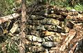
Remains of a bush hut, Berowra area
-
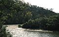
Berowra Creek
-
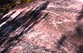
Aboriginal rock carving, Berowra area
-
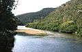
Junction of Berowra and Calna Creeks


Schools in Berowra
Berowra and nearby Berowra Heights have several primary schools for younger students:
- Berowra Public School (in Berowra)
- Pacific Berowra Christian School (in Berowra)
- Wideview Public School (in Berowra Heights)
- St Bernard's Catholic Primary School (in Berowra Heights)
Churches in the Community
There are four churches that serve the communities of Berowra and Berowra Heights:
- St Mark's Anglican Church (in Berowra)
- Berowra Baptist Church (in Berowra)
- St Bernard's Catholic Church (in Berowra Heights)
- Berowra Uniting Church (in Berowra Heights)
Clubs and Community Groups
Berowra has many clubs and groups where people can get involved:
- Apex
- Berowra Musical Society
- Berowra Toastmasters
- Berowra Rotary Club
- Lions Club
- Scouts
- Girl Guides
- The Probus club of Berowra
- Netball Club
- Soccer Club
- Football Club
- Cricket Club
Berowra's Population
In 2021, the population of Berowra was 4,762 people. Most residents, about 72.2%, were born in Australia. The next largest group, 7.1%, were born in England. About 84% of homes in Berowra speak only English. Most homes in Berowra are separate houses, making up 93.9% of all dwellings.
Famous People from Berowra
- Margaret Preston - a well-known Australian painter.
Exciting Local Events
Every year, Berowra hosts a fun event called the Annual Woodchop Festival. It takes place on the second Sunday of August. This festival has been running since 1995 and attracts thousands of visitors each year.
