Bert, Allier facts for kids
Quick facts for kids
Bert
|
||
|---|---|---|

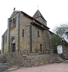
The church in Bert
|
||
|
||
| Country | France | |
| Region | Auvergne-Rhône-Alpes | |
| Department | Allier | |
| Arrondissement | Vichy | |
| Canton | Moulins-2 | |
| Intercommunality | Pays de Lapalisse | |
| Area
1
|
24.15 km2 (9.32 sq mi) | |
| Population
(2013)
|
256 | |
| • Density | 10.600/km2 (27.45/sq mi) | |
| Time zone | UTC+01:00 (CET) | |
| • Summer (DST) | UTC+02:00 (CEST) | |
| INSEE/Postal code |
03024 /03130
|
|
| Elevation | 285–487 m (935–1,598 ft) (avg. 314 m or 1,030 ft) |
|
| 1 French Land Register data, which excludes lakes, ponds, glaciers > 1 km2 (0.386 sq mi or 247 acres) and river estuaries. | ||
Bert is a small town or village in the center of France. It is officially called a "commune." Bert is located in the Allier department.
Contents
What is Bert?
Bert is a French commune. A commune is the smallest type of local government area in France. Think of it like a town or a village. It has its own local council and a mayor.
Where is Bert located?
Bert is found in the Auvergne region of France. More specifically, it is in the Allier department. The Allier department is in the central part of France. Bert is also part of the Vichy arrondissement. An arrondissement is a larger administrative area.
How many people live in Bert?
According to information from 2013, about 256 people live in Bert. This makes it a very small community. The area of Bert is about 24.15 square kilometers. This is roughly 9.3 square miles.
Who leads the commune?
The leader of Bert is called the mayor. As of the 2014-2020 term, the mayor was Jacques Caillault. The mayor helps manage the daily life of the commune. They work with the local council.
See also
 In Spanish: Bert (Allier) para niños
 | Aaron Henry |
 | T. R. M. Howard |
 | Jesse Jackson |


