
Bethanga Bridge facts for kids
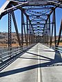
{{Infobox bridge | name = Bethanga Bridge | native_name = | native_name_lang = | image = Bethanga Bridge 2010 003.JPG | image_size = 270 | image_upright = | alt = | caption = The Bethanga Bridge, pictured in 2010 | pushpin_map = New South Wales | pushpin_relief = 1 | pushpin_map_size = 270 | pushpin_map_alt = | pushpin_map_caption = Location on the New South Wales / Victorian border | coordinates = 36°05′25″S 147°03′32″E / 36.09019°S 147.05902°E | os_grid_reference = | carries = Riverina Highway ![]() /
/ ![]() | crosses = Lake Hume, Murray River | locale = Bellbridge, Victoria, and Bethanga, New South Wales, Australia | official_name = | other_name = | named_for = Bethanga
| crosses = Lake Hume, Murray River | locale = Bellbridge, Victoria, and Bethanga, New South Wales, Australia | official_name = | other_name = | named_for = Bethanga
| owner =
- Roads and Maritime Services NSW
- VicRoads
| maint = Roads and Maritime Services NSW | heritage = | id = | id_type = | website = | preceded = | followed = | design = Pratt truss | material = Steel, concrete | material1 = Timber deck replaced by concrete waffle slab in 1961 | material2 = Double reinforced concrete pylons | length = 752 metres (2,467 ft) | width = 7.7 metres (25 ft) | height = | depth = | traversable = | towpath = | mainspan = 82 metres (269 ft) | number_spans = 9 | piers_in_water = 8 | load = | clearance_above = 4.2 metres (14 ft) | clearance_below = 25 metres (82 ft) | lanes = 2 | life = | num_track = | track_gauge = | structure_gauge = | electrification = | architect = | designer = Percy Allan | contracted_designer = NSW Department of Main Roads | winner = | engineering = NSW Department of Public Works | builder = Vickers Ruwolt, Melbourne | fabricator = | begin = 1927 | complete = 1930 | cost = c. A£194,000 – 210,000 | open = September 1930 | inaugurated = | rebuilt = | collapsed = | closed = | replaces = | replaced_by = | traffic = | toll = | map_type = | map_relief = | map_dot_label = | map_image = | map_size = | map_alt = | mapframe = yes | mapframe_zoom = 14 | mapframe_width = | mapframe_height = | mapframe_marker = | mapframe_marker_color = | mapframe_lat = | mapframe_long = | map_caption =
| extra = The Bethanga Bridgeis a large steel road bridge in Australia. It carries the Riverina Highway across Lake Hume, which is a big artificial lake on the Murray River. This bridge is special because it crosses the border between two Australian states: New South Walesand Victoria. It connects the towns of Bellbridgein Victoria and Bethanga in New South Wales with the city of Albury. The Bethanga Bridge is considered important for its history and engineering. It's listed on the heritage registers of both New South Wales and Victoria.
Contents
- Why Was the Bridge Built?
- Building the Hume Dam and Lake Hume
- Who Designed and Built the Bridge?
- How Was the Bridge Built?
| Official name | Bethanga Bridge |
|---|---|
| Type | State heritage (built) |
| Designated | 26 May 2006 |
| Reference no. | 1750 |
| Type | Road Bridge |
| Category | Transport - Land |
| Builders | Vickers Ruwolt, Melbourne |
| Official name | Bethanga Bridge |
| Type | State heritage (built) |
| Designated | 14 July 2005 |
| Reference no. | 12738 |
| Type | Road Bridge |
| Category | Transport - Land; Utilities - Water |
| Builders | Vickers Ruwolt, Melbourne |
History of the Bethanga Bridge
Why Was the Bridge Built?
The Murray River was first explored by Europeans in 1824. Early settlers and their livestock needed ways to cross the river. At first, people could walk across when the water was low. When the river was high, they used a log punt (a type of flat-bottomed boat) built in 1844. Animals had to swim!
The first bridge over the Murray River was built in 1860 near Albury. But people living further away still needed easier ways to cross.
Mining also became important in the Bethanga area, especially for copper and gold. This brought more people and the need for better transport.
Building the Hume Dam and Lake Hume
The idea of building dams on Australian rivers for irrigation (watering crops) and flood control started a long time ago. The Hume Dam was a huge project planned by the Australian government and the states of New South Wales, Victoria, and South Australia.
Construction of the Hume Dam began in 1919 and took 17 years to finish, opening in 1936. At its busiest, over 1,100 workers lived in towns built just for them near the dam site.
The Bethanga Bridge was built while the dam was being constructed, between 1927 and 1930. As the dam wall grew, the water behind it rose, covering the old low-level crossing at Bethanga. This made a new, higher bridge necessary.
Who Designed and Built the Bridge?
The Bethanga Bridge was a joint effort between New South Wales and Victoria. It's believed that the New South Wales Public Works Department and the Victorian State Rivers and Water Supply Commission worked together on its design and construction.
The bridge's design is similar to the Yarrawonga Bridge, which was designed by Percy Allen, an engineer from New South Wales. This shows a pattern where New South Wales often designed bridges over the Murray River, and Victoria helped build them.
The steel parts for the bridge were made by a company called Vickers Ruwolt in Melbourne. They even put together one of the main sections of the bridge in their factory first, to make sure it would fit perfectly.
How Was the Bridge Built?
Building the Bethanga Bridge was a big job. It started in 1927 with clearing the ground and putting in the foundations. By 1928, the concrete piers (the tall supports) were being built. Special temporary structures were used to help workers put the large steel sections of the bridge into place. These sections were put together on site using hot rivets, which are like strong metal bolts.
The construction was so impressive that photos and lantern slides were made to show its progress. These were even used to promote tourism to the area, showing the bridge as a great engineering achievement. The bridge cost about A£194,000 to A£210,000 to build, which was a lot of money back then!
In 1963, a shorter section was added to the New South Wales side of the bridge as part of upgrades to the Hume Dam. The town of Bellbridge was created because the original town was covered by the rising waters of Lake Hume.
What Does the Bethanga Bridge Look Like?
The Bethanga Bridge is a long road bridge that crosses a wide part of the Murray River that is now part of Lake Hume.
Bridge Structure and Design
The bridge has nine main sections, each about 82 metres (269 ft) long. These sections are supported by strong concrete pylons (tall columns) and use a special design called a "Pratt truss." A Pratt truss is a type of bridge structure made of steel beams that form a pattern of triangles. This design is very strong and was often used for railways.
The bridge also has a shorter section, about 14 metres (46 ft) long, on the New South Wales side. The total length of the bridge is about 752 metres (2,467 ft).
When it was first built, the road surface was made of timber (wood). But in 1961, it was replaced with a stronger concrete "waffle slab" deck. The road is about 7.7 metres (25 ft) wide. In 1961, the bridge was also raised by 300 millimetres (12 in) to handle the increased water levels from the enlarged Hume Dam.
In 2005, the concrete deck was replaced again to make it even stronger for modern traffic. New safety rails were added, and the approach road on the New South Wales side was made wider.
Unique Location
The border between New South Wales and Victoria runs along the southern bank of the Murray River. This means that all structures built over the river are technically in New South Wales. However, because the Bethanga Bridge crosses Lake Hume, which has the border running through its middle, it's the only structure that is officially shared by both New South Wales and Victoria. It's listed on both states' heritage registers!
Why is the Bethanga Bridge Important?
The Bethanga Bridge is important for several reasons:
- Historical Significance: It's a key part of the Hume Dam project, which was a huge national effort in the early 1900s to manage the Murray River. The bridge shows how New South Wales, Victoria, and South Australia worked together to share water resources.
- Engineering Significance: The bridge uses a "Pratt truss" design, which was more common in New South Wales but rare in Victoria. This shows how engineers from both states cooperated, with New South Wales designing it and Victoria helping with construction. It's a great example of how this strong bridge design works over long distances.
- Social Significance: For local communities, the Bethanga Bridge is a very important link. It connects the Bethanga and Granya areas to the larger regional center of Albury-Wodonga. It's also a popular spot for tourists.
- Rarity: The Bethanga Bridge is unique because it's one of the few major bridges not built by a state road or rail authority, but by water authorities. It's also the only built structure that is officially shared by both New South Wales and Victoria.
The Bethanga Bridge received an Engineering Heritage Marker from Engineers Australia, recognizing its importance in Australian engineering history.
Gallery
-
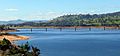
Bethanga Bridge in 2014.
-
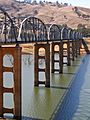
Bethanga Bridge in 2007, during drought.
-

Bethanga Bridge in 2010.
-
-
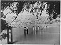
Unknown date, from the NSW State Records.


