Beverlywood, Los Angeles facts for kids
Quick facts for kids
Beverlywood
|
|
|---|---|
| Country | United States |
| State | California |
| County | Los Angeles |
| City | Los Angeles |
Beverlywood is a friendly neighborhood located in the Westside area of Los Angeles, California. It is known for its many single-family homes and a strong community feel.
Contents
History of Beverlywood
Beverlywood was created in 1940 by Walter H. Leimert. He also developed another area called Leimert Park. This neighborhood has 1,354 single-family homes.
It was one of the first neighborhoods in Los Angeles to have special rules. These rules are called "CC&Rs," which stands for Covenants, Conditions, and Restrictions. The Beverlywood Homes Association manages these rules.
Rules for Homes in Beverlywood
The CC&Rs are very strict about how houses look. They control the size, style, color, and design of homes. There are also rules about how people can landscape their yards. A special committee makes sure everyone follows these rules. All residents must pay fees to the Beverlywood Homes Association.
In recent years, some people have built very large new houses. This is sometimes called "mansionization." Even though these new homes follow the HOA rules, some residents feel they change the neighborhood's look. These residents have asked the Los Angeles City Council to set new limits on house sizes.
Geography of Beverlywood
Beverlywood is located in a busy part of Los Angeles. It is surrounded by other neighborhoods.
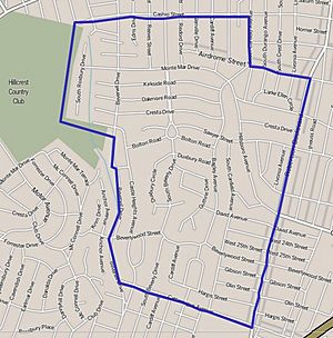
Beverlywood Homes Association Borders
The Beverlywood Homes Association has its own specific borders. These borders are marked by special signs and monuments.
- To the north: Monte Mar Drive
- To the west: Hillcrest Country Club and Anchor Avenue
- To the south: Beverlywood Street
- To the east: Robertson Boulevard
Beverlywood is next to Pico-Robertson (north). It is also near Crestview, La Cienega Heights, and Reynier Village (east). To the south is Castle Heights. To the west is Cheviot Hills.
Mapping L.A. Boundaries
The Los Angeles Times has a project called Mapping L.A.. This project defines Beverlywood with wider borders. These wider areas do not always follow the strict rules of the Beverlywood Homes Association.
According to Mapping L.A., Beverlywood's borders are:
- North: Cashio Street and Airdrome Street
- East: Canfield Avenue and Robertson Boulevard
- South: Cattaraugus Avenue
- West: Beverwil Drive and the Hillcrest Country Club
These wider borders include areas like Castle Heights and West Helms. These areas have their own neighborhood groups.
Population in Beverlywood
In 2000, about 6,080 people lived in Beverlywood. The neighborhood is about 0.79 square miles. This means there were about 7,654 people per square mile. This number is about average for Los Angeles. By 2008, the population grew to about 6,418 people.
The average age of residents in 2000 was 39. This is older than the average age for Los Angeles. Many residents were between 35 and 49 years old, or 65 and older.
The neighborhood is not considered very diverse in terms of ethnic backgrounds. A large percentage of residents are white. About 24.5% of residents were born outside the United States. This is a low number for Los Angeles. Many of these residents came from Iran or Israel.
The average household income in 2008 was about $105,253 per year. This is a high income for Los Angeles. Many households earned $125,000 or more. The average household had 2.5 people. About 70.3% of homes were owned by the people living in them. The rest were rented.
In 2000, there were few families led by a single parent. This was a low number compared to the rest of the city. Also, many residents had served in World War II or the Korean War.
Education in Beverlywood
Many adults in Beverlywood have a good education. In 2000, 55% of residents aged 25 and older had a four-year college degree. This is a high number for Los Angeles. Many also had a bachelor's degree or a master's degree.
Here are some schools located within Beverlywood:
- Canfield Avenue Elementary School, part of LAUSD, at 9233 Airdrome Street.
- Castle Heights Elementary School, LAUSD, at 9755 Cattaraugus Avenue.
- Cheviot Hills Continuation School, LAUSD, at 9200 Cattaraugus Avenue.
Students living in Beverlywood typically attend these secondary schools:
- Palms Middle School
- Hamilton High School
Parks and Recreation
The Beverlywood Homes Association owns and takes care of several private parks. Most of these parks are gated. This means only Beverlywood residents can use them. One park, Circle Park, is an exception.
 | Roy Wilkins |
 | John Lewis |
 | Linda Carol Brown |


