
Big Basin Prairie Preserve facts for kids
Quick facts for kids Big Basin Prairie Preserve |
|
|---|---|
|
IUCN Category IV (Habitat/Species Management Area)
|
|

Kansas Historical Marker
|
|

Big Basin Prairie Preserve
Location in the United States
|
|
| Location | Clark County, Kansas, USA |
| Nearest city | Ashland |
| Area | 1,818 acres (736 ha) |
| Established | 1978 |
| Operator | Kansas Department of Wildlife and Parks |
| http://www.kdwp.state.ks.us/news/KDWP-Info/Locations/Wildlife-Areas/Region-3/Big-Basin-Prairie-Preserve KDWP | |
The Big Basin Prairie Preserve is a special nature area in Kansas. It covers about 1,818 acres (that's like 1,377 football fields!). This preserve is looked after by the Kansas Department of Wildlife and Parks. You can find it in the Red Hills region, near the town of Ashland in Clark County, Kansas.
The preserve has two main cool features. One is called St. Jacob's Well. It's a deep hole in the ground filled with water, known as a sinkhole. The other is the Big Basin itself. This is a huge, mile-wide, bowl-shaped area that also formed from a sinkhole. It's a really green and beautiful spot. You can even see buffalo roaming here, and the preserve is open for everyone to visit!
The Big Basin is crossed by two highways, U.S. Route 283 and U.S. Route 160. The land on the west side of the highway is privately owned. The preserve was bought in 1974 from an organization called The Nature Conservancy. They made sure the land would always be used to protect nature. In 1978, the Big Basin Prairie Preserve was named a National Natural Landmark. This means it's a very important natural place in the United States.
The land in the preserve goes from about 2,200 feet to 2,360 feet above sea level.
Contents
A Look Back: History of Big Basin
The Big Basin area has a long and interesting history.
Native American Use
Back in the fall of 1878, the Northern Cheyenne people camped and rested here. They were on a long journey known as the Northern Cheyenne Exodus. At that time, not many settlers lived in the area. It might not have even been widely known to them.
Cattle Drives and Watering Holes
The Big Basin was also an important landmark and a place to get water. This was especially true for cattle drives. These were times when cowboys moved large groups of cattle north from Texas to Kansas. The cattle were then loaded onto trains.
Early Observations of the Basin
Around the year 1900, a scientist named Willard D. Johnson visited Big Basin. He worked for the United States Geological Survey. In 1901, he wrote about what he saw:
- Big Basin is about a mile wide and 100 feet deep. It's shaped like a circle. Water often collects in shallow ponds on its floor. Next to it is a smaller basin, also without an outlet. A short distance east is another, called Little Basin. On the edge of Little Basin is a sharp sinkhole called St. Jacob's Well. This well shows where the underground water is. The floor of Little Basin has many small dips. These look like old sinkholes that have mostly filled in. St. Jacob's Well looks like it formed more recently.
Research has shown that St. Jacob's Well is 84 feet wide and 58 feet deep. It's amazing because it has never been known to dry up!
-
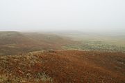
Big Basin in the fog.
-
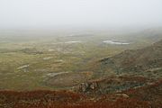
The wet floor of Big Basin.
-
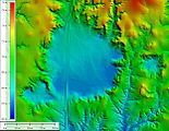
Shaded elevation map.


How the Preserve Was Created
The idea to protect the Big Basin area started in 1972. A citizen from Clark County, Mrs. C.G. (Janie) Stein, was very interested. She created the Big Basin Foundation. For several years, she worked with many groups and people. She talked to local landowners and The Nature Conservancy. Her goal was to set aside this land. She wanted to protect the bison and pronghorn animals living there. Her son, John Paul Stein, even wrote a song about his mother's hard work on this project.
