Big Round Top facts for kids
Quick facts for kids Big Round Top |
|
|---|---|
| Round Top — Great Round Top Round Top Mountain — Sugar Loaf Hill[1] |
|

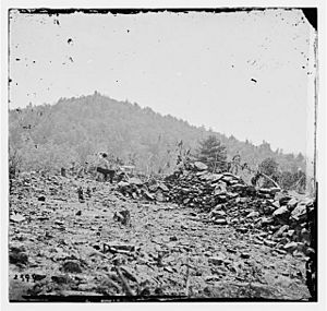
1863 O'Sullivan image of Big Round Top
beyond Little Round Top breastworks |
|
| Location | NE slope @ Little Round Top |
| Coordinates | 39°47′21.44″N 77°14′12.53″W / 39.7892889°N 77.2368139°W |
| Geology | Pennsylvania Piedmont physiographic region |
| Website | Gettysburg Scenic Vistas (nps.gov) |
Big Round Top is a rocky hill covered in boulders. It's the highest point on the Gettysburg Battlefield in Pennsylvania. This hill is famous because of important battles that happened here during the American Civil War in 1863. Some soldiers even received the Medal of Honor for their bravery on or near this hill. Today, you can find battle monuments and the remains of an old observation tower on Big Round Top.
Contents
Where is Big Round Top?
Big Round Top is the southern part of the Gettysburg Battlefield. It's surrounded by a low area to the southeast and south, and a stream called Plum Run to the west and north. Other important places nearby include Little Round Top, Devil's Den to the northwest, and the Valley of Death to the north.
This hill is the highest point of a ridge in Adams County, Pennsylvania. Plum Run divides this ridge at Big Round Top. Other nearby hills include Warfield Ridge to the west and Houck Ridge to the north-northwest. The closest taller hill is Carr Hill. On the lower slopes of Big Round Top, there's a cool rock formation and small cave known as "Devil's Kitchen."
How Big Round Top Was Formed
Big Round Top was formed about 200 million years ago! It's made of igneous rock, which means it was created from hot, melted rock that cooled and hardened deep underground. Over time, this rock pushed up through older layers. Later, during the Ice Age (called the Pleistocene period), ice and freezing water broke the rock into many large boulders. This is why the hill is covered in so many rocks today.
Long before the Civil War, Native Americans lived in this area. They cleared some land on the slope of Big Round Top and even had a burial ground about a mile southwest. This was before the British bought the land in 1736.
Big Round Top During the Civil War
During the Battle of Gettysburg in July 1863, Big Round Top's steep slopes, thick woods, and many boulders made it impossible to place cannons on its top. This meant it couldn't be used as a strong artillery position like some other hills.
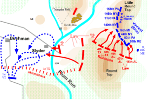
On the second day of the battle, July 2, as darkness fell, Confederate soldiers were still on Big Round Top. It was very important for the Union army to control this hill because it overlooked their battle lines. Union soldiers were sent to take the hill and successfully drove the Confederates away.
Later that night, Colonel Joshua Chamberlain and his 20th Maine Volunteer Infantry Regiment took up a position on the summit of Big Round Top. Chamberlain was later awarded the Medal of Honor for his bravery in taking this position and for defending Little Round Top earlier that day.
On the third day of the battle, July 3, Union cavalry led by General William Wells charged from the west. They went past Big Round Top and attacked the Confederate soldiers from behind. This action helped the Union take control of the hill, and Wells also received the Medal of Honor in 1891 for his leadership.
After the war, people began to protect the battlefield. By September 1863, David McConaughy started buying parts of Big Round Top to preserve them. Monuments to important figures like Elon J. Farnsworth, William Wells, and John Michael Tobin were later placed on the hill.
After the War
After the Civil War, roads were built around Big Round Top to make it easier for visitors to explore the battlefield. Kilpatrick Avenue was finished by 1895, and South Confederate Avenue was built across the northwest slope. In 1903, Wright Avenue was added. These roads were even rebuilt in 1937 for the 75th anniversary of the battle, which brought many veterans back together.
In 1940, workers from the Civilian Conservation Corps (CCC) rerouted the stone path to the summit of Big Round Top. Even President Harry Truman visited the hill in 1946. In 1964, the Big Round Top Nature Trail was created, allowing people to hike around the hill and visit Devil's Kitchen.
The Old Observation Tower
In the late 1800s, an observation tower was built on Big Round Top. This tower was meant to give visitors a great view of the battlefield. It was built using large granite blocks that were moved to the summit with a special engine. Since Big Round Top is the highest point on the battlefield, the tower offered amazing views.
There were plans to replace this tower with a much larger "Gettysburg Peace Memorial" for the 1938 anniversary reunion. This new memorial would have had a tall observation deck and a flame even higher. However, that memorial was built on Oak Hill instead.
Why the Tower Was Taken Down
In 1968, during maintenance work, the Big Round Top tower was taken apart. It was decided that the tower was too old and expensive to fix. Also, it was very hard for people to reach because the path to it was long, uphill, and winding. Many visitors who started the climb would give up before reaching the top.
Today, only the foundation of the old tower remains. This foundation is now considered a historic ruin and was officially recognized as a historic site in 2004.
 | Claudette Colvin |
 | Myrlie Evers-Williams |
 | Alberta Odell Jones |


