
Big Skin Bayou facts for kids

Big Skin Bayou, also known as Skin Bayou or Big Skin Creek, is a stream that flows into the Arkansas River. It is found in Sequoyah County, Oklahoma. Its name comes from the French word "skein," which means tangled layers of yarn. This name was given because a large, colorful area of tall cane plants, looking like tangled yarn, once formed a thick natural wall near the creek's mouth. French explorers and trappers named many streams in Oklahoma. This area was once part of French territory called Louisiana, which was later bought by the United States in the Louisiana Purchase.
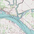
Long ago, there were big rock cliffs near where Big Skin Bayou meets the Arkansas River. Most of these cliffs were later removed to help build the W.D. Mayo Lock and Dam. One cliff on the south side of the river was called Swallow Rock. It was named for the birds that nested there and was the site of old Fort Coffee. Another cliff on the north side, west of Big Skin Bayou, is known as Wilson Rock. Both cliffs were natural docks for steamboats and places where people could cross the river by ferry. The cemetery at Wilson Rock holds the graves of local people and some travelers. Tiana, the wife of the famous Texan Sam Houston, was buried there for a time before being moved. Wilson Rock and Big Skin Bayou were also important stops for Cherokee people. They were forced to move to Oklahoma during the Trail of Tears. Many Cherokees got off boats here and followed the creek into the area where they settled. Much of eastern Sequoyah County was part of the "Skin Bayou District" of the Cherokee Nation, named after the creek.
Journey of Big Skin Bayou
Big Skin Creek starts in the Brushy Mountains. This area is in northern Sequoyah and southern Adair Counties. The creek flows southeast. It meets Black Creek near Sequoyah's Cabin and the town of Maple. Sequoyah was an important leader of the Cherokee Tribe. He created the Cherokee Syllabary, which is their writing system.
From Creek to Bayou
After passing Sequoyah's Cabin, the creek gets wider. Its flow also slows down as it gets closer to U.S. Highway 64, near Muldrow. At this point, it becomes known as Big Skin Bayou. It forms the northern and eastern edge of the Redland community.
Path to the Arkansas River
The bayou then flows under U.S. Interstate 40. This is just north of where it meets Little Skin Bayou and Tomlin Branch. These smaller streams are near the community of Baldridge. Big Skin Bayou continues southeast, passing south of the Lee's Chapel community. Here, the bayou splits into two parts. These parts form Breedlove Island and Cherokee Chute. Finally, Big Skin Bayou empties into the Arkansas River. This happens just upstream from the W.D. Mayo Lock and Dam.
Images for kids
-
Map showing Big Skin Bayou in Oklahoma
