
Birch Coulee Battlefield facts for kids
|
Birch Coulee
|
|

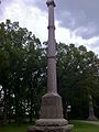
Birch Coulee Battlefield with a monument
|
|

Location in Minnesota

Location in the United States
|
|
| Location | Junction of Renville County Highways 2 and 18, Birch Cooley Township, Minnesota |
|---|---|
| Nearest city | Morton, Minnesota |
| Area | 82 acres (33 ha) |
| NRHP reference No. | 73000995 |
Quick facts for kids Significant dates |
|
| Fought | September 2–3, 1862 |
| Added to NRHP | June 4, 1973 |
The Birch Coulee Battlefield is a special historical place in Renville County, Minnesota. It was the site of the Battle of Birch Coulee in 1862. This battle was a very costly fight for the U.S. forces during the Dakota War of 1862.
Today, Birch Coulee is a historic site. You can walk on self-guided trails and read signs that explain the battle. These signs tell the story from both sides. The battlefield was added to the National Register of Historic Places in 1973 because of its important role in military history.
Contents
What is Birch Coulee?
In 1862, the area around Birch Coulee Battlefield was mostly open prairie. This means it was a wide, flat grassland stretching out to the north and west. There were woods to the south.
On the east side of the battlefield, there is a deep, wooded valley. This type of valley is called a "coulee," which is a French word. Birch Coulee is about 60 feet (18 meters) deep. It runs for about 7 miles (11 kilometers) down to the Minnesota River. The Dakota people called it Tanpa Yukan, meaning "Place of the White Birch." A short distance west of the coulee, the land rises slightly to a small hill.
The Battle of Birch Coulee
On September 1, 1862, a group of about 170 U.S. soldiers and civilians set up camp. They were led by Major Joseph R. Brown. They camped on the prairie west of Birch Coulee.
A group of Dakota soldiers, led by Zitkahtahhota (Gray Bird), were on their way to attack New Ulm. They happened to find the U.S. soldiers camping in a spot that was easy to attack. The Dakota soldiers hid in the ravine and the tall prairie grass. At dawn, they surrounded the camp and attacked. They caused many injuries and killed most of the army's horses.
The U.S. group was trapped. They dug in behind their dead horses and were cut off from fresh water. The Dakota kept up the attack all day. They used occasional gunfire and the hot sun to wear down the U.S. soldiers.
About 16 miles (26 kilometers) away at Fort Ridgely, a guard heard distant gunshots. A group of 240 men was sent to check. They came close enough to see their trapped comrades. But Dakota soldiers, hidden in the coulee and led by Mankato, started making loud noises. The relief party thought there were hundreds of Dakota waiting to ambush them, so they turned back.
A larger relief party, led by Colonel Henry Hastings Sibley, marched through the night. When the Dakota saw them, they quietly left. This ended the battle, which had lasted for 30 hours. The U.S. forces lost thirteen men, nearly fifty were wounded, and ninety horses were killed. The Dakota leader Wamditanka (Big Eagle) later said only two men on his side were killed.
Protecting the Battlefield
The first attempt to save the Birch Coulee Battlefield happened in 1893. The Minnesota Legislature set up a group to buy the land. They had $2,500 and the power to take land if needed. But, for some reason, this group bought a 1.75-acre (0.71-hectare) property about 2 miles (3.2 kilometers) south of the actual battlefield. They put up a 46-foot (14-meter) granite monument there. At the dedication ceremony in 1894, former governor William Rainey Marshall criticized the group for their mistake.
In 1895, the state legislature gave more money and clear instructions to buy land on the real battlefield. But nothing happened. It wasn't until 1929, after people in the community pushed for it again, that the state finally bought the correct site. They named it the Birch Cooley Battle Field State Memorial Park.
In 1937, a Works Progress Administration (WPA) crew helped improve the park. They replanted the land and built things like trails, roads, a picnic area, and a parking lot.
In 1976, the park was renamed a state historic site. Its management was given to the Minnesota Historical Society. The Historical Society improved the battlefield starting in 1998, and it reopened to the public in 2000. Now, there are signs that explain the battle from the viewpoints of Captain Joseph Anderson and Wamditanka. These signs have drawings by a soldier named Albert Colgrave. Markers show where the U.S. camp was and where the Dakota soldiers were positioned.
Today, the Renville County Parks Department manages the battlefield. They also have a campground nearby.
Images for kids
-
Birch Coulee State Monument in 2011
-
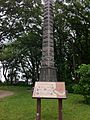
Faithful Indians' Monument in 2011


