Black Rock Dam (Schuylkill River) facts for kids
Quick facts for kids Black Rock Dam |
|
|---|---|

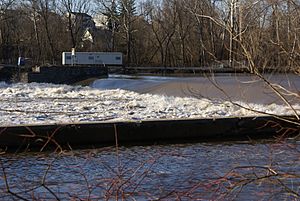
Black Rock Dam with flood waters. Canal forebay in foreground.
|
|
|
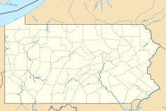
Location of Black Rock Dam in USA Pennsylvania
|
|
| Country | United States |
| Location | Chester / Montgomery counties, Pennsylvania |
| Coordinates | 40°08′52″N 75°30′22″W / 40.14778°N 75.50611°W |
| Opening date | c. 1825 |
| Owner(s) | Exelon |
| Dam and spillways | |
| Impounds | Schuylkill River |
| Length | 480 feet (150 m) main 900 feet (270 m) fore bay |
| Reservoir | |
| Creates | Black Rock Pool |
| Power station | |
| Hydraulic head | low |
|
Black Rock Dam
|
|
|
U.S. Historic district
Contributing property |
|
| Part of | Schuylkill Navigation Canal, Oakes Reach Section Historic District (ID88000462) |
The Black Rock Dam is a low dam built across the Schuylkill River in Pennsylvania, USA. It was first built in the early 1800s. This dam was one of many dams that helped create a system of calm water pools. These pools were important for the Schuylkill Canal, which was a waterway used by boats to transport goods.
The Black Rock Dam is located between the towns of Phoenixville and Mont Clare. It is recognized as a historic landmark.
Contents
What is the Black Rock Dam?
The Black Rock Dam is a special type of dam called a "low head dam." This means it is not very tall. It was originally made from timber (wood) and filled with stones. Its main job was to help boats travel along the Schuylkill Canal.
The dam created deeper, calmer sections of the river. These sections were like long, still pools. Boats could easily move through these pools. This made it much easier to transport coal and other goods.
How the Dam Was Built
The original dam had a unique "L" shape. One part of the "L" went straight across the river. This created the low spillway, where water flowed over the top.
The longer part of the "L" ran parallel to the riverbank. This section was called a "forebay." It acted like a long channel that led to a special gate called Lock 60. Lock 60 was a "guard lock" for the Oakes Canal section of the Schuylkill Navigation System. Locks are like water elevators that help boats move between different water levels.
In 1828, another lock was added to the dam. This was part of the Chester County Canal. This canal helped power local industries and later allowed boats to reach Phoenixville. However, a big flood in 1869 damaged this canal.
Changes Over Time
Over the years, the Black Rock Dam saw some important changes.
Early Power Generation
In 1902, three special machines were added to the forebay. These machines were called hydroelectric generators. They used the power of flowing water to create electricity. This electricity was used to power a local trolley system.
Today, these generators are no longer there. However, the dam is still owned by a power company called Exelon.
Dam Extension
Later in the 1900s, the dam was made even longer. The part that went across the river was extended. This made the dam a straight line from one riverbank to the other. This change also closed off the forebay section.
Helping Fish Migrate
In 2008, something very important was added to the dam: a fish ladder. A fish ladder is a series of pools or steps that help fish swim upstream. It's like a staircase for fish!
This fish ladder was built to help the American shad fish. These fish migrate, meaning they travel long distances to lay their eggs. The dam used to block their path. Now, with the fish ladder, they can swim past the dam and continue their journey up the Schuylkill River.
During the building of the fish ladder, workers found old parts of the Chester County Canal. Archeologists studied these old structures. This helped them learn more about the dam's history.
 | Stephanie Wilson |
 | Charles Bolden |
 | Ronald McNair |
 | Frederick D. Gregory |


