
Schuylkill Canal facts for kids
Quick facts for kids Schuylkill Navigation |
|
|---|---|

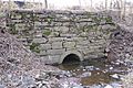
Lock 60, guard lock of the Oakes Reach.
|
|
| Specifications | |
| Length | 90 miles (140 km) (originally 108 mi or 174 km) |
| Maximum boat length | 110 ft 0 in (33.53 m) |
| Maximum boat beam | 18 ft 0 in (5.49 m) (originally 13 ft 0 in or 3.96 m) (Size of Lock 60) |
| Locks | 44 (originally 72) |
| Original number of locks | 72 |
| Maximum height above sea level | 618.75 ft (188.60 m) (above mid tide of Delaware River) |
| Status | Mostly infilled |
|
Schuylkill Navigation Canal, Oakes Reach Section
|
|

Location in Pennsylvania

Location in the United States
|
|
| Nearest city | Phoenixville, Pennsylvania |
| Area | 155.3 acres (62.8 ha) |
| Built | 1821 |
| Architect | Thomas Oakes |
| NRHP reference No. | 88000462 |
| Significant dates | |
| Added to NRHP | May 6, 1988 |
| History | |
| Principal engineer | Thomas Oakes |
| Construction began | 1815 |
| Date completed | 1827 |
| Date closed | 1947 |
| Geography | |
| Start point | 40°34′42″N 76°01′35″W / 40.57833°N 76.02639°W (originally 40°41′37″N 76°09′52″W / 40.69361°N 76.16444°W) (18 miles (29 km) above Port Clinton abandoned by December 1887) |
| End point | 39°58′02″N 75°11′16″W / 39.96722°N 75.18778°W |
The Schuylkill Canal, also called the Schuylkill Navigation, was a system of connected canals and calm water areas along the Schuylkill River in Pennsylvania. It was built in the early 1800s to help transport goods. The company that built it was formed in 1815, and the canal opened in 1825.
At that time, rivers were the cheapest way to move heavy cargo. Cities on the East Coast of the U.S. needed more fuel because many forests had been cut down. The canal helped transport anthracite coal, which became a major industry. Mules pulled barges full of coal from places like Port Carbon to Pottsville, and then to Philadelphia. Some coal even went by ship to New York City.
The Schuylkill Canal was used until 1931. Most of it was filled in during the 1950s. Today, some parts of the canal still have water and are used for fun activities like boating.

Contents
Building the Canal

In 1815, several canal projects started in the U.S., including the Schuylkill Navigation. People realized that the U.S. needed better ways to move goods by water, like Europe had. The Erie Canal and the Lehigh Canal showed that canals could work well. This inspired many people to invest in new canal projects across North America.
Before canals, it was hard to move coal. Many people didn't even believe coal could burn!
... while there was a total lack of highways or navigable streams leading to the region. Small quantities of coal were mined, but people were slow to appreciate its value, and it required vigorous exertions to induce them to attempt to use it. Its very appearance was against it, and the majority of persons approached were entirely incredulous as to its being anything else than a stone, incapable of being burned by any inherent qualities it possessed. Not only the coal but the fact that it was coal had to be discovered. Even as late as the year 1812, when it was sought to secure an act authorizing the improvement of the Schuylkill river in order to convey coal to Philadelphia, the representative of Schuylkill county in the state senate declared there was no coal in his district; that there was a kind of black stone that was called coal, but that it would not burn!
—Fred Brenckman, History of Carbon County
The Schuylkill Navigation Company was formed in 1815. Its goal was to improve the Schuylkill River for boats. Two important investors, White and Hazard, wanted a steady supply of fuel for their factories. They also helped start the Lehigh Canal. Both the Lehigh and Schuylkill canals faced similar challenges. They had to make rivers with fast-moving water safe for boats.
The Schuylkill Canal started working in 1825. By 1827, it was 108 miles (174 km) long, connecting Philadelphia to Port Carbon near Pottsville. The canal had 62 miles (100 km) of separate canal sections and 46 miles (74 km) of calm water areas. It used 92 locks to raise and lower boats. This helped boats travel over a 588 feet (179 m) change in height between the start and end points. Canals often changed over time, with improvements made after floods or ice damage.
By the early 1820s, coal from the Lehigh and Schuylkill canals helped lower heating costs. It solved the fuel shortages in Eastern cities. The Auburn Tunnel, a 450 foot (140 m) long tunnel, was finished in 1821. Later, it was made into an open cut to handle more boat traffic. The Union Canal was built to connect the Susquehanna River to the Schuylkill Canal at Reading. This created a water route between Philadelphia and the Susquehanna River.
The Schuylkill Canal helped towns like Reading, Norristown, and Pottsville grow into early manufacturing centers. Goods and coal could also reach New York Harbor using the Delaware River and other canals. The Schuylkill Canal became the main way to transport coal from Schuylkill County to Philadelphia. By 1841, it moved over 737,517 tons of cargo each year.

Canal vs. Railroads
In 1841, the Philadelphia and Reading Railroad opened. Within four years, it was moving three times more coal to Philadelphia than the Schuylkill Canal. To compete, the Schuylkill Navigation Company made its canals wider. By 1847, their boats could carry 230 tons of coal. These boats were much bigger than those on other canals.
In 1850, the canal company and the railroad agreed on prices for moving coal. This helped the canal have its best years. In 1859, it moved 1,700,000 tons of cargo. However, in the same year, the railroad carried even more coal, over 2,500,000 tons.

By the 1860s, railroads became the main way to transport goods. They were faster and more powerful. Like most canals in North America, the Schuylkill Canal was used less for general cargo. Railroads could reach coal mines where canals could not be built. While canals still served their markets, their importance slowly decreased. Also, oil heat became popular, and canals had problems delivering goods in winter when water froze. Many canals, including the Schuylkill Navigation, closed during the Great Depression.
The Canal's Decline
In 1869, a flood damaged the Schuylkill Navigation. It took time to repair. In 1870, the Schuylkill Navigation Company leased its canal to the Philadelphia and Reading Railroad for 110 years. This meant the canal gave up to its railroad competition.
Under the railroad's control, the canal was used less for general cargo. It mainly carried coal, as many people still needed coal for heating and steam power. The canal's traffic dropped even more when the Pennsylvania Railroad bought the Delaware and Raritan Canal in 1872. This meant Schuylkill boats could no longer use that important waterway to reach New York City.
By 1890, only 144,994 tons of cargo went through the Schuylkill Navigation. Coal silt (fine dirt) also made the upper parts of the canal hard to use. By 1891, the part of the canal above Port Clinton was no longer used. After 1913, very few cargo boats used the canal. Pleasure boats continued to use it until most of the canals were filled in by Pennsylvania between 1947 and 1979. This was done to remove coal silt from the Schuylkill River.
Chester County Canal
The Chester County Canal, also called the Phoenixville Branch Canal, was added to the Schuylkill Navigation in 1828. It was built to power a new nail factory in Phoenixville. This canal connected to the calm water of the Schuylkill Canal above the Black Rock Dam. It ran on the opposite side of the river from the Oakes Reach.
The Chester County Canal first provided water power to the factory. Later, in 1847, it offered passenger boat service between Phoenixville and Norristown. A flood in 1869 destroyed the factory and badly damaged the canal and its locks.
The Canal Today
Many of the old dams are still there, but only a few parts of the canal still have water. About 2.5 miles (4.0 km) of the original 3.5 miles (5.6 km) long Oakes Reach (between Oaks and Mont Clare) remains. Also, a 1 mile (1.6 km) section in Manayunk still has water.
You can still see ruins and parts of the canal's structures along its path. Many of the lock chambers (the parts that raise and lower boats) still exist, but they are partly buried. Some of the houses where lock tenders (people who operated the locks) lived are also still standing. Even where the canal is filled in, its history is remembered by several "Canal Streets" in towns along the river.
In Leesport, a locktender's house has been restored. The lock next to it was filled in for a car wash, but in 2011, the car wash was removed, and the lock was uncovered. Near Gibraltar, the Allegheny Creek Aqueduct (a bridge that carried the canal over a creek) still exists, along with a drained part of the canal. This Aqueduct is listed on the National Register of Historic Places.
Oakes Reach
The Oakes Reach starts at the Black Rock Dam (Dam #26) near Mont Clare. The canal goes through Lock #60 at the dam. The Schuylkill Canal Association, a group of volunteers, has restored Lock 60 so it can work again.


The locktender's house nearby has also been restored. The Reach goes under Pennsylvania Route 29 in Mont Clare, across the river from Phoenixville, and then through Port Providence. A basin from the silt removal project cuts the canal after Longford Road. The last mile of the Reach has been filled in. An old stone aqueduct that carried the Canal over Crossman's Run, and the house for the lock tender at the end, are still there. However, Lock 61, called Brower's Lock, was filled in.
This part of the canal is named after Thomas Oakes, who was the main engineer for the Schuylkill Navigation Company. The Oakes Reach canal, its locks, locktenders' houses, Black Rock Dam, and the calm water area up to the Pennsylvania Route 113 bridge are all part of a historic district called the "Schuylkill Navigation Canal, Oakes Reach Section."
- Lock 60 40°08′42″N 75°30′28″W / 40.14500°N 75.50778°W
- Present end of reach 40°07′42″N 75°28′57″W / 40.12833°N 75.48250°W
- Lock 61 Tender's House 40°07′34.6″N 75°27′40.9″W / 40.126278°N 75.461361°W
Manayunk Reach
The Manayunk Reach starts at the Flat Rock Dam (Dam 31) near Shawmont. The canal originally went through Lock 68 at the dam. However, Lock 68 is now closed off, and the area above it has filled with silt.


This part of the canal forms the northern side of Venice Island. At the end of this section, the canal goes through Manayunk and returns to the river using Locks 69 and 70. All three lock structures still exist.
- Lock 68 40°02′17″N 75°14′40″W / 40.03806°N 75.24444°W
- Locks 69&70 40°01′22″N 75°13′11.5″W / 40.02278°N 75.219861°W
Schuylkill River Trail
The Schuylkill River Trail (SRT) now follows parts of the old canal route. In Manayunk, the Trail was built across the canal from the towpath (the path where mules pulled boats).
In 2008, an extension of the Schuylkill River Trail opened. This part of the Trail uses the path of the filled-in Oakes Reach and originally used the old canal aqueduct to cross Crossman's Run. Work to restore the towpath along the watered part of the Oakes Reach began in 2014 and reopened in 2015.
-
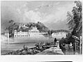
"Schuylkill Waterworks" (1835), with Schuylkill Canal in the foreground.
-
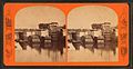
Locks on Schuylkill Canal.
-
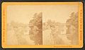
Bridge over Schuylkill Canal.
-
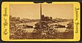
Mouth of the Schuylkill Canal, below Fairmount Dam, Philadelphia. The Wire Bridge (background) stood at the site of the current Spring Garden Street Bridge.
.jpg)


,_Pennsylvania,_from_Robert_N._Dennis_collection_of_stereoscopic_views.jpg)
Images for kids
-
Canal aqueduct over Crossman's Run, near Oaks
