
Lehigh Canal facts for kids
Quick facts for kids |
|
|
Lehigh Canal
|
|

The canal as seen from Guard Lock 8 and Lockhouse, Island Park Road, Glendon, Northampton County, Pennsylvania
|
|

Lower division of the canal, from Jim Thorpe to Easton, Pennsylvania
|
|
| Location | Lehigh River Upper: Nesquehoning, Pennsylvania to White Haven, Pennsylvania Lower: Mauch Chunk (Jim Thorpe) to Delaware River at Easton, Pennsylvania |
|---|---|
| Built | 1818-1821; 24-27 upper: 1838-1843, Upper ruined & abandoned: 1862 |
| Architect | Canvass White, Josiah White |
| Architectural style | Fitted stone, iron and wood |
| NRHP reference No. | 78002437, 78002439, 79002179, 79002307, 80003553 |
| Added to NRHP | Earliest October 2, 1978 |
The Lehigh Canal is a historic waterway in eastern Pennsylvania. It was built in two main parts, starting in 1818. The lower section stretched from Easton, Pennsylvania to Mauch Chunk (now Jim Thorpe). In Easton, it connected with the Delaware Canal and Morris Canal. This allowed goods to travel further along the East Coast. At its longest, the Lehigh Canal was about 72 miles (116 km) long.
The canal was used to move many different products. But its most important cargo was anthracite coal and pig iron. These materials were vital for the American Industrial Revolution. They helped shape the towns along the canal.
The canal's path included both man-made canals and parts of the Lehigh River that were dammed. Boats had to move from the canal through special gates called locks onto the river, or vice versa. This design saved time and money during construction. However, it made the journey a bit slower and harder for boat captains.
Contents
History of the Lehigh Canal
Building the Canal
The Lehigh Coal Mine Company (LCMC) started in 1792. This was soon after anthracite coal was found near Summit Hill, Pennsylvania. The company easily found coal on the mountainside. But moving it was a big problem. Coal had to be put into sacks and carried by pack animals for about 9 miles (14 km) to the Lehigh River. Then, temporary boats called arks were built from local wood. These arks floated the coal down the lower Lehigh River.
Getting coal to Philadelphia was very difficult. Before the War of 1812, coal from England was often cheaper. The war made American coal more important. In 1813, a new effort was made, but it still didn't work well. Many people who supported the company gave up.
But two men, Josiah White and Erskine Hazard, kept trying. They were known for new ideas. They even helped build the first wire suspension bridge over the Schuylkill River. They realized that the Lehigh Coal Mine Company was struggling to make money. The company had rights to improve the Lehigh River for navigation, but hadn't done much.
In 1818, White and Hazard got a special permission. It gave their new company, the Lehigh Navigation Company, control of the Lehigh River. They could improve it for boats. Their first plan was to make it easier for boats to travel downstream only. They would build low walls in the river to make the water deeper. They also planned to create "artificial freshets" (small floods) by releasing water from ponds. This would help boats move regularly.
The Lower Canal: "The Stone Coal Turnpike"

The lower part of the canal was sometimes called "The Stone Coal Turnpike." It was about 46.5 miles (74.8 km) long. It was first built between 1818 and 1820 by the Lehigh Navigation Company. At first, it was only for boats traveling downstream. Its main job was to bring coal from the southern Coal Region to cities on the East Coast. This included Philadelphia, Trenton, and Wilmington.
The lower canal started near Mauch Chunk (now Jim Thorpe). It had 44 special gates called lift locks. The first lock was a "weighing lock." It could lift a barge and weigh it to figure out how much coal it carried. This helped the company charge tolls based on the weight and distance traveled. Most of the locks were a special "bear-trap lock" design invented by Josiah White. When opened, they would release a lot of water. This created a wave that helped the canal boat move downstream.
The canal helped new industries grow in places like Bristol, Allentown, and Bethlehem, Pennsylvania. It connected with other canals like the Morris Canal and the Delaware and Raritan Canal. This network of waterways and later railroads became part of the larger Pennsylvania Canal system. The Lehigh Canal was used for cargo until 1942. In 1964, it was sold to Pennsylvania for people to use for fun. Today, parts of it are used as a walking and biking trail.
First Steps in Building
Josiah White was the main engineer for the lower canal. By 1822, people were starting to believe in anthracite coal. But the company was worried about the cost of building a new ark for every load of coal. So, White started working with Canvass White, an engineer from the Erie Canal. They began to change the canal to allow boats to travel in both directions. This new design had wider locks that were over 120 feet (37 m) long. These could handle steam tugs and larger cargo ships.
More Construction and Changes
In 1823, Josiah White suggested building more improvements along the Lehigh River. He wanted locks big enough for coastal ships. But the Pennsylvania government said no. Lumber companies worried that dams would stop them from floating logs down the river.
However, in 1827, money was set aside for the Delaware Canal. So, the Lehigh Coal & Navigation Company started changing the Lehigh Canal for two-way traffic. This work finished in 1829. By 1831, the company stopped building one-way arks. Instead, they built strong, reusable barges. They expected these barges to return from Easton by connecting with the Delaware Division of the Pennsylvania Canal.
The improved Lehigh Canal was 46 miles (74 km) long. It had 52 locks, 8 guard locks, 8 dams, and 6 aqueducts. These structures helped boats climb over 350 feet (107 m) in elevation. A special "weigh lock" near Mauch Chunk measured boats to calculate fees. A ferry across the Delaware River connected the Lehigh Canal to the Morris Canal in New Jersey. This created a more direct route to New York City.
Expanding to the Upper Canal
People were impressed by how freight was moved over the Allegheny Mountains using the Allegheny Portage Railroad. So, in the 1830s, there was a push to extend the Lehigh Canal. The Upper Lehigh Canal was designed by Canvass White. It was built from 1837 to 1843.
The upper Lehigh River was very wild, with steep sides and deep ravines like the Lehigh Gorge. The upper canal had to rise over 600 feet (183 m) to reach Mauch Chunk. Unlike the lower canal, which had many small lifts, the upper canal used "deep-lift locks." Some of these locks lifted boats as much as 58 feet (18 m) at a time. The upper canal had 20 dams, 29 locks, and several reservoirs to keep water flowing even in dry summers.
This big project also included three new railroad lines. The Lehigh Coal & Navigation Company created a new company, the Lehigh and Susquehanna Railroad, to build them. These railroads helped connect the canal to coal mines further north. By 1855, the canal was moving over one million tons of cargo. But after that, coal from the Schuylkill Valley started to take over, and the Lehigh Canal's traffic began to decline.
The Canal's End
The canal's downfall began with a huge flood in June 1862. A very wet spring caused dams to break, one after another. This created a massive flood that destroyed parts of the canal and nearby villages. Between 100 and 200 lives were lost. After this disaster, the Pennsylvania government decided not to rebuild the upper canal.
The lower canal continued to be used for transportation until the 1940s. It was one of the last fully working towpath canals in North America. In 1962, most of it was sold to different groups. Today, it is used for fun activities like hiking and boating.
Modern History of the Canal
Several parts of the canal were recognized as important historic places in 1979. These include sections in Carbon County, Glendon, and from Allentown to Hopeville. The eastern section is now a place for recreational boating. It runs along the Lehigh River to where it meets the Delaware River in Easton. This section also includes the Chain Bridge, which is a historic landmark.
Present Activities
Today, about 8 miles (13 km) of the canal's towpath have been turned into a multi-use trail. This trail runs from Freemansburg through Bethlehem to Allentown. It follows the river and active railroad tracks. Another section near Jim Thorpe is also open for people to enjoy. The last section in Easton is cared for by the National Canal Museum. While some other short parts of the canal path can be accessed, many are worn out and not safe to use.
Gallery
-
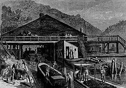
Weigh lock with scales to determine tolls, 1873
-
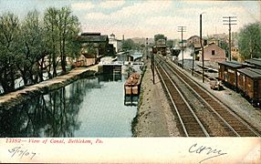
The canal in Bethlehem, 1907
-
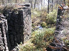
Remains of Upper Canal Lock 24 (2020)
-
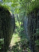
Entrance to Lock 28 near White Haven (2008)
-
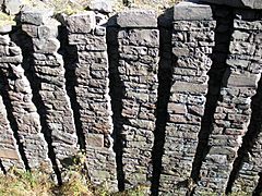
Stacked-rock detail of Upper Canal Lock 28 near White Haven (2008)


Images for kids
-
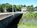
Main Street Bridge over the canal in Freemansburg, July 2015

