Freemansburg, Pennsylvania facts for kids
Quick facts for kids
Borough of Freemansburg
|
||
|---|---|---|

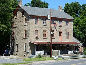
Jacob Freeman House in Freemansburg in July 2015
|
||
|
||

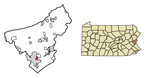
Location of Freemansburg in Northampton County, Pennsylvania (left) and of Northampton County in Pennsylvania (right)
|
||
| Country | ||
| State | ||
| County | Northampton | |
| Area | ||
| • City | 0.74 sq mi (1.93 km2) | |
| • Land | 0.70 sq mi (1.81 km2) | |
| • Water | 0.05 sq mi (0.12 km2) | |
| Elevation | 325 ft (99 m) | |
| Population
(2020)
|
||
| • City | 2,875 | |
| • Density | 4,124.82/sq mi (1,591.51/km2) | |
| • Metro | 865,310 (US: 68th) | |
| Time zone | UTC-5 (EST) | |
| • Summer (DST) | UTC-4 (EDT) | |
| ZIP Code |
18017
|
|
| Area codes | 610 and 484 | |
| FIPS code | 42-27760 | |
| Primary airport | Lehigh Valley International Airport | |
| Major hospital | Lehigh Valley Hospital–Cedar Crest | |
| School district | Bethlehem Area | |
Freemansburg is a small town, called a borough, in Northampton County, Pennsylvania. In 2020, about 2,875 people lived there. The Lehigh River, a long river that flows into the Delaware River, runs right through Freemansburg.
Freemansburg is part of a bigger area called the Lehigh Valley. This larger area is home to many people and is one of the most populated metropolitan areas in the United States.
Contents
History of Freemansburg
Early Settlers and Growth
The first people to settle in the Freemansburg area were the Bachman family in the 1760s. Their old stone house, which also served as a tavern, is still standing today. The Bachmans faced attacks from local Native American tribes who lived across the Lehigh River.
Soon after, the Freeman family joined them, along with Moravians from nearby Bethlehem. These new settlers built mills, a place to make drinks (a distillery), and another tavern.
Becoming a Town
In 1811, a bridge was built over the Lehigh River in Freemansburg. The town continued to grow, with the first doctor arriving in 1817 and the first general store opening in 1825. By the 1830s, Freemansburg was becoming a real community. A public school was built in 1838. During this time, Jacob Freeman, who the town is named after, started running a local tavern.
Freemansburg officially became an independent borough in January 1856. It had a government system where the main leader, called the Chief Burgess, was an honorary position. George Bachman was the first Chief Burgess.
Town Council and Community Life
Freemansburg has a seven-member town council. This is the same number as Bethlehem, even though Bethlehem is much larger! The council has seen many changes in its members over the years. There has also been a friendly rivalry between people who were born and raised in Freemansburg (called "burgers") and those who moved in from Bethlehem.
Where is Freemansburg?
Freemansburg is located at 40°37′38″N 75°20′23″W / 40.62722°N 75.33972°W. The U.S. Census Bureau says the borough covers about 0.8 square miles (2.1 km2) of land. A small part of this area, about 0.04 square miles (0.10 km2), is water.
Getting Around Freemansburg
As of 2018, Freemansburg has about 10.24 miles (16.48 km) of public roads. Most of these roads are taken care of by the borough itself. A smaller portion is maintained by the Pennsylvania Department of Transportation (PennDOT).
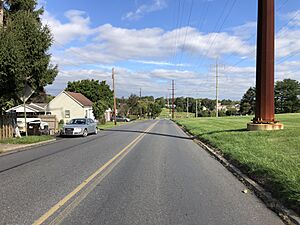
There are no major highways that go directly through Freemansburg. However, important streets like Freemansburg Avenue, Washington Street, Main Street, Market Street, and Cambria Street help people get around the borough.
People of Freemansburg
Population Changes Over Time
| Historical population | |||
|---|---|---|---|
| Census | Pop. | %± | |
| 1860 | 649 | — | |
| 1870 | 643 | −0.9% | |
| 1880 | 634 | −1.4% | |
| 1890 | 615 | −3.0% | |
| 1900 | 596 | −3.1% | |
| 1910 | 867 | 45.5% | |
| 1920 | 1,203 | 38.8% | |
| 1930 | 1,777 | 47.7% | |
| 1940 | 1,728 | −2.8% | |
| 1950 | 1,739 | 0.6% | |
| 1960 | 1,652 | −5.0% | |
| 1970 | 1,681 | 1.8% | |
| 1980 | 1,879 | 11.8% | |
| 1990 | 1,946 | 3.6% | |
| 2000 | 1,897 | −2.5% | |
| 2010 | 2,636 | 39.0% | |
| 2020 | 2,875 | 9.1% | |
| Sources: | |||
The population of Freemansburg has grown quite a bit. From 2000 to 2010, the number of people living in the borough increased by 39%. In 2010, there were 2,636 residents. By 2020, the population reached 2,875.
Diversity in Freemansburg
The community in Freemansburg is diverse. In 2010, about 59.7% of residents were White, 12.7% were African American, and 24% were Hispanic or Latino. There were also smaller percentages of Native Americans and Asians.
Households and Families
In 2010, there were 687 households in Freemansburg.
- About 34.4% of these households had children under 18 living with them.
- 54.4% were married couples living together.
- 23.3% of all households were made up of people living alone.
The average household had 2.64 people, and the average family had 3.06 people.
Age and Income
The people in Freemansburg come from all age groups:
- 24.8% were under 18 years old.
- 34.2% were between 25 and 44 years old.
- 12.5% were 65 years or older.
The median age in the borough was 36 years. The median income for a household was about $44,297. This means half of the households earned more than this amount, and half earned less.
Education in Freemansburg
Students in Freemansburg attend schools within the Bethlehem Area School District. This school district serves the borough and provides public education for its young residents.
See also
 In Spanish: Freemansburg para niños
 | Jewel Prestage |
 | Ella Baker |
 | Fannie Lou Hamer |


