Blackett, New South Wales facts for kids
Quick facts for kids BlackettSydney, New South Wales |
|||||||||||||||
|---|---|---|---|---|---|---|---|---|---|---|---|---|---|---|---|

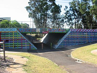
Road bridge on the cycleway passing Blackett Primary School, showing artwork
|
|||||||||||||||
| Population | 3,452 (2016 census) | ||||||||||||||
| Postcode(s) | 2770 | ||||||||||||||
| Elevation | 50 m (164 ft) | ||||||||||||||
| Location | 48 km (30 mi) west of Sydney CBD | ||||||||||||||
| LGA(s) | City of Blacktown | ||||||||||||||
| State electorate(s) | Mount Druitt | ||||||||||||||
| Federal Division(s) | Chifley | ||||||||||||||
|
|||||||||||||||
Blackett is a suburb located in Sydney, New South Wales, Australia. It's about 48 kilometres west of the main city area, known as the Sydney central business district. Blackett is part of the City of Blacktown local government area and the wider Greater Western Sydney region.
Contents
Discovering Blackett's Past
Blackett gets its name from a person called George Forster Blackett. He was in charge of the Government Cattle Station at Rooty Hill from 1820 to 1830.
Blackett is mostly a place where people live. There aren't many big shops or businesses here. You'll find a small shopping area with a few stores. This includes a general store, a butcher, a bakery, and a take-away shop. There's also a service station that sells general items. These shops serve the local residents, especially those from Pacific Islander backgrounds.
For bigger shopping trips, people often go to nearby suburbs. Mount Druitt and St Marys are popular choices. These suburbs have larger shopping centres, banks, and train stations. Other nearby places with shops include Emerton and Plumpton, though they don't have train access.
Getting Around Blackett
Most people in Blackett use cars to get to work. In 2016, about 61.3% drove themselves. Another 10.4% traveled as car passengers.
Blackett is very close to the Westlink M7 motorway. This big road makes it easy to reach other major highways. You can quickly get to the Great Western Highway and the M4 Motorway. These roads connect Blackett to other parts of western Sydney and even to the Sydney city centre.
If you need to catch a train, private bus companies link Blackett to the train stations. You can find these stations in Mount Druitt and St Marys.
For those who love cycling, Blackett has cycleways. These paths start at Poppondetta Park and go all the way to Mount Druitt. They also connect to the M7 cycleway. From there, you can link up with cycleways on the M4 and M2 Motorways.
Schools in Blackett
Blackett has two public schools for students.
- Blackett Public School opened its doors in 1971.
- Niland Special School also serves the community.
Blackett's Community
The 2016 census counted 3,452 people living in Blackett.
- About 10.6% of the people were Aboriginal and Torres Strait Islander.
- Most residents, 63.9%, were born in Australia.
- The next most common birthplaces were New Zealand (5.5%) and Samoa (3.0%).
- English was the main language spoken at home for 68.0% of people.
- Other languages spoken included Samoan (5.0%), Arabic (1.9%), and Tongan (1.7%).
- When it came to religion, the most common choices were Catholic (25.9%), No Religion (21.8%), and Anglican (17.0%).
Homes in Blackett
Most of the homes in Blackett were built by the government. This happened mainly in the 1960s and 1970s. Many of these were separate houses made of fibro (a type of building material). There were also many terrace-style homes, which are rows of attached houses.
Over time, these government-built homes are being sold to private owners. As this happens, new, modern homes are being built in their place. These new houses are similar to those you might see in other parts of Sydney.
In Blackett, about 89.6% of the homes where people live are separate houses.
 | Sharif Bey |
 | Hale Woodruff |
 | Richmond Barthé |
 | Purvis Young |

