Emerton, New South Wales facts for kids
Quick facts for kids EmertonSydney, New South Wales |
|||||||||||||||
|---|---|---|---|---|---|---|---|---|---|---|---|---|---|---|---|

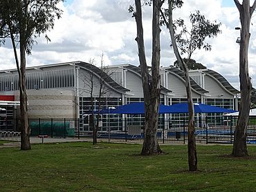
Emerton Leisure Centre
|
|||||||||||||||
| Population | 2,252 (2016 census) | ||||||||||||||
| • Density | 2,820/km2 (7,300/sq mi) | ||||||||||||||
| Postcode(s) | 2770 | ||||||||||||||
| Elevation | 46 m (151 ft) | ||||||||||||||
| Area | 0.8 km2 (0.3 sq mi) | ||||||||||||||
| Location | 46 km (29 mi) W of Sydney CBD | ||||||||||||||
| LGA(s) | City of Blacktown | ||||||||||||||
| State electorate(s) |
|
||||||||||||||
| Federal Division(s) | Chifley | ||||||||||||||
|
|||||||||||||||
Emerton is a suburb located in Sydney, New South Wales, Australia. It's about 46 kilometres west of the main city centre of Sydney. Emerton is part of the City of Blacktown area and is found in the Greater Western Sydney region.
Emerton is mostly a place where people live. It has a few shops and services, mainly around the Emerton Leisure Centre. It is also quite close to the suburbs of Mount Druitt, New South Wales and St Marys.
The edges of Emerton are marked by Popondetta Road to the south and east. This road continues north around Popondetta Park. To the west, the boundary follows Halmahera Creek. When the creek meets Luxford Road, the boundary then follows that road south until it reaches Popondetta Road.
Contents
Emerton's History
Emerton gets its name from a man called William Frederick Emert. He was born in Siglingen, Germany, and came to Australia in 1853. In 1861, he became a shopkeeper and postmaster in Mount Druitt. William Emert also helped start the Wesleyan Church in Australia.
Shops and Services
You can find several shops near the corner of Jersey and Popondetta Roads. The main shopping area is called 'Emerton Village'. Here, you'll find an Australia Post office, a supermarket, a petrol station, and medical centres. There are also places to buy take-away food and a hotel. For banking, you can use EFTPOS at shops or find ATMs.
Getting Around Emerton
Road Transport
Emerton is close to the Westlink M7 motorway. This road makes it easy to get to the Great Western Highway and the M4 Motorway. These motorways help you travel to the western parts of Sydney and also east towards the Sydney city centre.
Public Transport
Several private bus companies connect Emerton to nearby train stations. You can catch a bus to Mount Druitt or St Marys train stations.
Cycleways
There are special paths for bikes, called cycleways, that run through Emerton. These paths go from Popondetta Park all the way to Mount Druitt. They also connect to the M7 cycleway, which then links to other cycleways on the M4 and M2 motorways. This makes it easy to cycle around the area.
Homes in Emerton
The most common types of homes in Emerton are:
- Separate houses.
- Semi-detached houses, row houses, or townhouses.
- Flats, units, or apartments.
Fun and Recreation
Leisure Centre
The Emerton Leisure Centre is a great place for fun. It used to be called Emerton Pool. After a big upgrade by Blacktown City Council, it reopened in August 2006. In 2017, the centre was renamed the Charlie Lowles Leisure Centre.
The leisure centre has both indoor and outdoor swimming pools. It even has a special hydrotherapy pool for gentle exercise. Outside, you can find a beach volleyball court.
Popondetta Park
Right next to the leisure centre is Popondetta Park. This large park stretches between Popondetta Road and Halamahera Creek. It goes from Jersey Road to Bougainville Road. The park has many sports fields where you can play cricket, netball, rugby league, and soccer.
Emerton's Population
According to the 2016 census, there were 2,252 people living in Emerton.
- About 6.8% of the people were Aboriginal and Torres Strait Islander people.
- Most people, 58.0%, were born in Australia. The next largest group, 6.7%, were born in New Zealand.
- About 64.3% of people spoke only English at home. Other languages spoken included Samoan (5.8%), Tongan (2.6%), Cook Islands Maori (2.2%), and Arabic (1.7%).
- The most common religions were Catholic (25.5%), No Religion (18.2%), and Anglican (14.7%).
- The average age of people was 31 years old. Children aged 0 to 14 years made up 25.4% of the population.
- The unemployment rate was 14.3%.
 | Aaron Henry |
 | T. R. M. Howard |
 | Jesse Jackson |

