Blackmans Bay, Tasmania facts for kids
Quick facts for kids Blackmans BayHobart, Tasmania |
|||||||||||||||
|---|---|---|---|---|---|---|---|---|---|---|---|---|---|---|---|

2008
|
|||||||||||||||
| Population | 7,688 (2021 census) | ||||||||||||||
| Postcode(s) | 7052 | ||||||||||||||
| LGA(s) | Kingborough | ||||||||||||||
| Federal Division(s) | Franklin | ||||||||||||||
|
|||||||||||||||
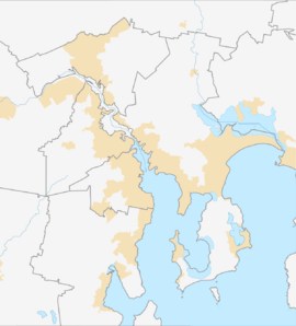
Blackmans Bay is a lovely coastal suburb in Tasmania, Australia. It's part of the Kingborough Council area. This suburb is connected to the bigger Kingston-Blackmans Bay urban area. It's also considered a satellite town of Greater Hobart, meaning it's a smaller town near a big city. Blackmans Bay is next to Kingston Beach to the north. To the west, you'll find Maranoa Heights and the Peter Murrell Conservation Area. To the south, it borders Howden and Tinderbox.
Contents
Why is it called Blackmans Bay?
Blackmans Bay gets its name from James Blackman. He owned land in this area way back in the 1820s. There's another place called "Blackman Bay" near Dunalley in Tasmania. That one was named in 1642 because Aboriginal Tasmanians lived there.
Exploring Blackmans Bay's Geography
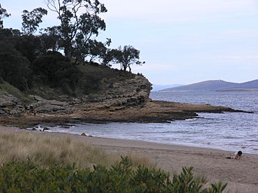
Blackmans Bay is built on hills. These hills surround a very popular sandy beach. It's a great spot for swimming and relaxing.
Cool Coastal Features
- The Blowhole: Near the northern end of the beach, there's a blowhole. Over time, the ocean waves have worn away the rock. This has created a large rock arch. You can see waves crashing through it, which is pretty cool! A local named James Baynton is said to have found it. He found his lost dog whimpering at its base.
- Flowerpot Point: At the southern end of the beach, you'll find rocks leading to Flowerpot Point. This is a popular place for fishing. However, it can be tricky to fish here. There's a lot of seaweed and rock ledges under the water.
- Quiet Pebble Beach: Just past Flowerpot Point, there's a quiet pebble beach. You can only get to this beach when the tide is low.
- Walking Tracks: The Suncoast Headlands walking track starts here. It goes south along the clifftops. This track leads to Soldiers Rocks. It's also a special area where dogs can exercise. There's a bushland loop walking track too.
- Fossil Cove: At the very southern edge of Blackmans Bay is Fossil Cove. You can reach it by following a steep walking track. This track starts from Fossil Cove Drive.
What's in Blackmans Bay?
Blackmans Bay has good facilities for its residents.
Schools for Kids
The suburb has three primary schools. These schools teach children from kindergarten up to grade six.
- Blackmans Bay Primary School
- Illawarra Primary School (started in the late 1980s)
- St. Aloysius (a Catholic school)
Shopping and Restaurants
- Bayview Market: This is the main shopping centre in the middle of the suburb. It has a supermarket where you can buy groceries. There's also a newsagency, a doctor's surgery, and a pharmacy. You can find many other stores there too.
- Restaurants: Blackmans Bay also has three restaurants. They are located right near the shore. This makes them a great place to eat with a view.
A Look at Blackmans Bay's History
Blackmans Bay has an interesting past. Even though people knew about the bay, it was settled quite late.
Early Days
- 1830 Description: An old book from 1830, called the Ross Almanack, described Blackmans Bay. It said it had "several small farms." It was a "romantically situated little settlement" with a "fine sandy beach." The potatoes grown there were very famous.
- First Settlers: By 1842, only a few families lived in the area. The main road from Hobart only went as far as Kingston Beach. To get to Blackmans Bay, you had to use a sandy track over the hill. One of the first settlers was William Sherburd. He was given 50 acres of land in 1818. He started farming it in 1819. Today, the oval in Blackmans Bay is named after him.
Slow Growth and Later Development
- Limited Access: Blackmans Bay didn't grow as fast as other nearby areas. This was because it didn't have a proper road or a jetty (a pier for boats). This made it hard to get to.
- Small Population: From 1830 to 1880, there wasn't much development. More farms grew, but the number of people living there didn't change much. Even by the 1930s, there were only six families listed as living in the area.
- Post-War Boom: After World War II, Blackmans Bay started to grow a lot faster. At the start of 1947, there were 57 families living there. By the end of that same year, the number had jumped to 343 families! This shows how quickly the area developed after the war.
Blackmans Bay Climate
| Climate data for Blackmans Bay | |||||||||||||
|---|---|---|---|---|---|---|---|---|---|---|---|---|---|
| Month | Jan | Feb | Mar | Apr | May | Jun | Jul | Aug | Sep | Oct | Nov | Dec | Year |
| Mean daily maximum °C (°F) | 22.0 (71.6) |
21.4 (70.5) |
20.2 (68.4) |
17.8 (64.0) |
15.0 (59.0) |
13.0 (55.4) |
12.6 (54.7) |
13.1 (55.6) |
15.0 (59.0) |
16.7 (62.1) |
18.4 (65.1) |
20.3 (68.5) |
17.1 (62.8) |
| Mean daily minimum °C (°F) | 13.5 (56.3) |
13.1 (55.6) |
10.4 (50.7) |
10.4 (50.7) |
8.5 (47.3) |
7.1 (44.8) |
6.4 (43.5) |
6.2 (43.2) |
7.7 (45.9) |
8.7 (47.7) |
10.2 (50.4) |
11.8 (53.2) |
9.7 (49.5) |
| Average precipitation mm (inches) | 32.6 (1.28) |
29.4 (1.16) |
43.6 (1.72) |
33.8 (1.33) |
51.5 (2.03) |
51.5 (2.03) |
43.9 (1.73) |
53 (2.1) |
38.5 (1.52) |
55.4 (2.18) |
46.2 (1.82) |
43.7 (1.72) |
530.6 (20.89) |
| Source: https://www.eldersweather.com.au/climate-history/tas/blackmans-bay | |||||||||||||
 | Jewel Prestage |
 | Ella Baker |
 | Fannie Lou Hamer |


