Blacksville, West Virginia facts for kids
Quick facts for kids
Blacksville, West Virginia
|
|
|---|---|

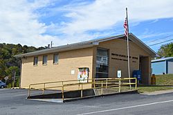
The community's post office
|
|

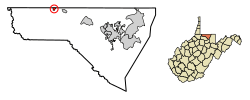
Location of Blacksville in Monongalia County, West Virginia.
|
|
| Country | |
| State | |
| County | |
| Government | |
| • Type | Mayor–council government |
| Area | |
| • Total | 0.31 sq mi (0.80 km2) |
| • Land | 0.30 sq mi (0.78 km2) |
| • Water | 0.01 sq mi (0.02 km2) |
| Elevation | 984 ft (300 m) |
| Population
(2020)
|
|
| • Total | 118 |
| • Estimate
(2021)
|
120 |
| • Density | 602.01/sq mi (232.11/km2) |
| Time zone | UTC-5 (Eastern (EST)) |
| • Summer (DST) | UTC-4 (EDT) |
| ZIP code |
26521
|
| Area code(s) | 304 |
| FIPS code | 54-08092 |
| GNIS feature ID | 1553918 |
Blacksville is a small town in Monongalia County, West Virginia, United States. In 2020, about 118 people lived there. It is part of the larger Morgantown area. Blacksville is an active, officially recognized town with its own local government.
Contents
History of Blacksville
Blacksville is named after David Black, a civil engineer from Virginia. He came to the area in 1800. Black bought 100 acres of land from Brice Worley for $50. In 1829, Black asked for permission to divide 160 acres of his land into plots. This was similar to creating a new neighborhood today.
On February 3, 1830, the Virginia General Assembly officially made Blacksville a town. During the American Civil War, Blacksville became an unincorporated community on June 20, 1863. This meant it no longer had its own local government. When West Virginia became a new state, the West Virginia Legislature officially made Blacksville a town again in October 1897.
Where is Blacksville?
Blacksville is located at 39°43′12″N 80°12′45″W / 39.72000°N 80.21250°W.
The United States Census Bureau says the town covers about 0.31 square miles (0.80 square kilometers). Most of this area, about 0.30 square miles (0.78 square kilometers), is land. A small part, about 0.01 square miles (0.02 square kilometers), is water.
How Many People Live Here?
| Historical population | |||
|---|---|---|---|
| Census | Pop. | %± | |
| 1880 | 106 | — | |
| 1900 | 180 | — | |
| 1910 | 204 | 13.3% | |
| 1920 | 218 | 6.9% | |
| 1930 | 269 | 23.4% | |
| 1940 | 261 | −3.0% | |
| 1950 | 241 | −7.7% | |
| 1960 | 211 | −12.4% | |
| 1970 | 264 | 25.1% | |
| 1980 | 248 | −6.1% | |
| 1990 | 168 | −32.3% | |
| 2000 | 175 | 4.2% | |
| 2010 | 171 | −2.3% | |
| 2020 | 118 | −31.0% | |
| 2021 (est.) | 120 | −29.8% | |
| U.S. Decennial Census | |||
Population in 2010
In 2010, there were 171 people living in Blacksville. These people made up 69 households, and 46 of those were families. The town had about 570 people per square mile. There were 79 homes, with about 263 homes per square mile.
Most of the people in Blacksville (97.1%) were White. About 2.9% were from two or more racial backgrounds.
- About 30.4% of households had children under 18.
- 44.9% were married couples living together.
- 14.5% had a female head of household with no husband.
- 7.2% had a male head of household with no wife.
- About 33.3% were not families.
The average household had 2.48 people, and the average family had 3.00 people. The average age in Blacksville was 35.2 years.
- 25.1% of residents were under 18.
- 8.2% were between 18 and 24.
- 28.1% were between 25 and 44.
- 26.4% were between 45 and 64.
- 12.3% were 65 or older.
The town had slightly more males (51.5%) than females (48.5%).
Schools in Blacksville
Monongalia County Schools manages the public schools in Blacksville. Students in Blacksville attend Mason Dixon Elementary School. They then go to Clay-Battelle Middle/High School.
Blacksville Pottery
In the middle of the 1900s, Blacksville was known for its pottery. Local people made pottery using clay found nearby. Edgar Richardson (1903-1962) taught pottery at Clay-Battelle High School. His beautiful pottery pieces were signed "E.R. - Blacksville." These pieces are still collected and sold today.
First Lady Eleanor Roosevelt visited Blacksville on June 28, 1938. She came to learn more about the "Blacksville pottery project."
See also
 In Spanish: Blacksville (Virginia Occidental) para niños
 | Sharif Bey |
 | Hale Woodruff |
 | Richmond Barthé |
 | Purvis Young |

