Blackwood River facts for kids
Quick facts for kids Blackwood River |
|
|---|---|
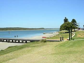
Colour patch area at mouth of Blackwood river and start of eastern section of estuary
|
|
| Country | Australia |
| Physical characteristics | |
| Main source | Junction of Arthur River and Balgarup River 219 metres (719 ft) |
| River mouth | Hardy Inlet, Augusta sea level |
| Length | 300 kilometres (186 mi) |
| Basin features | |
| Basin size | 28,100 km2 (10,849 sq mi) |
The Blackwood River is a really important river in the South West part of Western Australia. It's a big river system that plays a key role in the environment and history of the area.
Where the River Flows
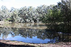
The Blackwood River starts where two other rivers, the Arthur River and the Balgarup River, meet near a place called Quelarup. From there, it flows southwest.
It travels through several towns, including Bridgetown and Nannup. Finally, it empties into the Southern Ocean at a place called Hardy Inlet, which is close to the town of Augusta.
Hardy Inlet has a few islands, like Molloy Island and Thomas Island. The river's mouth, where it meets the ocean, sometimes opens and closes. This has changed over the last 100 years.
The Blackwood River has many smaller rivers and streams that flow into it. These are called tributaries. Some of them are Dinninup Brook, Balingup Brook, St John Brook, Boyup Brook, Tweed River, Ti Tree Gully, Christmas Creek, and Tanjannerup Creek.
The River's Catchment Area
The "catchment area" of a river is all the land where rainwater drains into that river. The Blackwood River has a huge catchment area, covering about 28,100 square kilometers. It stretches from Kukerin in the east to Hardy Inlet in the west. It also goes from Darkan in the north down to Augusta in the south.
Many towns are located within this large area, such as Katanning, Narrogin, Bridgetown, and Nannup.
The upper part of the river's catchment is mostly used for farming, like growing crops and raising animals. The middle part flows through forests. The lower part of the river goes through a mix of forests, farms, and places where people live. This middle section crosses an area known as the Blackwood Plateau.
The river eventually flows into Flinders Bay near Augusta.
Most of the land in the river basin, about 78%, is used for agriculture. This includes growing grains and grazing livestock. Even with all this farming, there are still many important water sources, including over 1,000 wetlands, plus the river itself.
This river basin is home to an amazing variety of plants and animals. Scientists believe there are around 8,000 different types of plants. There are also 42 rare or important animal species and 143 rare or important plant species found here.
A Look Back in Time
Aboriginal people have lived along the Blackwood River for thousands of years. The Bibulman Noongar people had their own names for the river. They called it Gurbillup buerle, where "buerle" means "river." The part of the river near Bridgetown was known as Gigellup buerle.
In 1827, a British explorer named Captain James Stirling explored the river. He named it after Vice-Admiral Sir Henry Blackwood. Stirling had served under Blackwood in the navy.
The Blackwood River was very important in the early days of the Swan River Colony, which was one of the first European settlements in Western Australia. More recently, it has been important for the environment around Augusta and Margaret River.
Flooding History
The Blackwood River can sometimes flood. In 1945, it reached its highest recorded level at that time. The water went over the Russell Street bridge in Nannup. The river flooded again in 1946 and 1947, closing roads, but it didn't cause much damage to the towns.
In 1949, Nannup had a huge amount of rain in just seven hours, which caused more flooding. A bridge that connected Nannup to Busselton was washed away by the strong floodwaters.
Another big flood happened in 1982. After a tropical cyclone passed through the southwest, heavy rains caused the Blackwood River to rise very high. In Nannup, the river rose over 11 meters, and more than 50 houses in the town were flooded.
 | Bayard Rustin |
 | Jeannette Carter |
 | Jeremiah A. Brown |


