
Blair Gap facts for kids
Blair Gap is a special kind of valley called a water gap that cuts through the Allegheny Front, a big, steep edge of the Allegheny Mountains in Pennsylvania. Imagine a giant wall of mountains; a water gap is like a natural doorway through it, often carved by a river or stream. These gaps were super important long ago because they were some of the only easy ways for people to travel across the mountains.
For hundreds of years, Native Americans and later, settlers from the east, used Blair Gap. It was a path for people walking, leading pack mules, and even pulling wagons. This allowed them to journey west into areas like the Ohio Country, long before trains or cars existed.
Contents
How People Traveled Through Mountain Gaps
Before modern roads and railroads, traveling across the Appalachian Mountains was very difficult. The mountains were like a huge natural barrier. There were only a few main ways to get from the eastern side to the western side:
- Around the southern end of the mountains in Georgia.
- Through specific gaps like the Cumberland Gap and the Cumberland Narrows.
- Through the "gaps of the Allegheny Front," which include Blair Gap.
- Up the Hudson River in New York, then around the northern Catskill Mountains to the Great Lakes.
These gaps were like natural highways. They made it possible for people and animal-drawn wagons to cross the tough mountain terrain. Without them, moving goods and people would have been much harder, slowing down the growth and connection of the country.
Blair Gap's Role in History
Blair Gap played a key role in connecting the eastern and western parts of Pennsylvania. In the early 1800s, Pennsylvania wanted to link its two biggest cities, Pittsburgh in the west and Philadelphia in the east, using canals. Canals are man-made waterways for boats.
The Allegheny Portage Railroad
Because canals couldn't go straight over the steep Allegheny Mountains, engineers came up with a clever solution: the Allegheny Portage Railroad. This was a special railroad that used a series of inclined planes (slopes) and steam engines to pull canal boats, or sections of them, over the mountains. Blair Gap was a crucial part of this system, especially for the higher sections of the railroad.
The Allegheny Portage Railroad was authorized in 1824 as part of Pennsylvania's "Main Line of Public Works." This was a huge project to build canals and railroads across the state. It helped move goods and people much faster than before, boosting trade and settlement.
Modern Travel Through Blair Gap
Even in the early 1900s, Blair Gap continued to be an important travel route. US Route 22, a major highway, was built to follow the path through the gap. This shows how important these natural passages remained, even as transportation technology advanced from footpaths to railroads and then to highways.
Images for kids
-
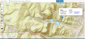
This map shows the location of Kittanning Gap near Altoona, Pennsylvania. It also highlights the nearby Horseshoe Curve, a famous railroad landmark. Kittanning Gap was another important natural passage through the mountains.

