Blodgett Peak facts for kids
Quick facts for kids Blodgett Peak |
|
|---|---|

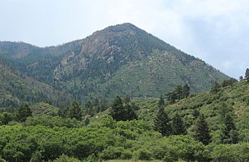
Blodgett Peak seen from the Blodgett Peak Open Space
|
|
| Highest point | |
| Elevation | 9,429 ft (2,874 m) |
| Geography | |
| Location | 3898 W. Woodmen Road, Colorado Springs, El Paso County, Colorado, U.S. |
| Parent range | Rampart Range |
| Topo map | USGS 7.5' topographic map Cascade, Colorado |
Blodgett Peak is a mountain in El Paso County, Colorado. This peak is part of the Pike National Forest. At its base, you'll find the Blodgett Peak Open Space in Colorado Springs.
Contents
Explore Blodgett Peak's Nature
Blodgett Peak is located within the 167-acre Blodgett Peak Open Space. This area is part of the Rampart Range in the Rocky Mountains. It is a special place for wildlife. You might even spot amazing birds like peregrine falcons here.
The open space also has trails for hiking. The ground is made of different types of rock. These include Pierre Shale and Fountain Formation. You can see many kinds of plants too. Look for scrub oak, Douglas fir, and ponderosa pine trees.
You can get to Blodgett Peak from Woodmen Road in Colorado Springs. It is about 16.3 kilometers (10.1 miles) northwest of downtown Colorado Springs.
The Story Behind Blodgett Peak
How Blodgett Peak Got Its Name
Blodgett Peak was named after a family. This family settled in the area a long time ago. Their land is now part of the Air Force Academy.
Blodgett Peak and NORAD
In 1959, Blodgett Peak was considered for a very important project. It was a possible site for the North American Aerospace Defense Command (NORAD) operations center. This center needed to be very strong and protected.
However, another mountain was chosen instead. The command center was built inside Cheyenne Mountain. This was because NORAD wanted a location close to Colorado Springs.
Restoring Blodgett Peak After the Fire
The Waldo Canyon Fire's Impact
Blodgett Peak was affected by a big fire in 2012. This fire was called the Waldo Canyon fire. The fire caused damage to the mountain and its surroundings.
Helping Blodgett Peak Recover
After the fire, a special project started. It was called the Blodgett Peak Restoration Project. The goal was to help the mountain heal. Workers focused on controlling soil erosion. They also removed dead trees from the trails.
Many groups worked together to restore the area. The United States Forest Service helped. So did the Rocky Mountain Field Institute. Cadets from the United States Air Force Academy joined in. The Mile High Youth Corp also helped. They fixed trails and planted new trees and seeds.
Money for the project came from different places. The Pikes Peak Community Foundation helped. Great Outdoors Colorado also provided funds. Thanks to these efforts, the open space was able to reopen. It was one of the first areas affected by the fire to welcome visitors again.
Hiking Blodgett Peak
The main hiking path starts in the Blodgett Peak Open Space. This trail is about 5 miles (8 kilometers) long, round trip. Hikers gain about 2,400 feet (732 meters) in height. The trail begins at an elevation of 7,158 feet (2,182 meters).
 | Ernest Everett Just |
 | Mary Jackson |
 | Emmett Chappelle |
 | Marie Maynard Daly |


