
Cheyenne Mountain facts for kids
Quick facts for kids Cheyenne Mountain |
|
|---|---|
 |
|
| Highest point | |
| Elevation | 9,570 ft (2,920 m) |
| Prominence | 1,141 ft (348 m) |
| Isolation | 1.87 mi (3.01 km) |
| Geography | |

Cheyenne Mountain
Location in Colorado
|
|
| Location | El Paso County, Colorado, U.S. |
| Parent range | Rampart Range |
| Topo map | USGS 7.5' topographic map Mount Big Chief, Colorado |
Cheyenne Mountain is a famous mountain in El Paso County, Colorado. It has three peaks and is located southwest of downtown Colorado Springs. This mountain is home to many important things. You'll find military buildings, communication towers, fun places to visit, and even homes here.
One of the most well-known parts of Cheyenne Mountain is the underground operations center for North American Aerospace Defense Command (NORAD). This secret base was built during the Cold War. Its main job was to watch North American airspace for missile launches and Soviet military planes. It was built deep inside solid granite rock. This made it strong enough to survive a nuclear bomb! After the Cold War ended, its job changed. Many of its tasks moved to Peterson Air Force Base in 2006.
People started living on the mountain in 1867. Resorts and retreats began to appear in the 1880s. A man named Spencer Penrose bought many properties here. He built The Broadmoor resort in 1918. Penrose also created the Cheyenne Mountain Zoo, the Cheyenne Mountain Highway, and the Will Rogers Shrine of the Sun. He even built a lodge on one of the mountain peaks and a retreat called Emerald Valley. Today, the lodge site is a wilderness camp called Cloud Camp. Emerald Valley is now The Broadmoor's Ranch at Emerald Valley. Some land once owned by The Broadmoor now has fancy homes. A community called Overlook Colony, started in 1911, still exists on the mountain.
Cheyenne Mountain also has two great parks. These are Cheyenne Mountain State Park and North Cheyenne Cañon Park. If you look at the top of one of the peaks, you'll see many antennas. These are used for cell phones, radio, television, and even law enforcement.
Contents
Exploring Cheyenne Mountain's Shape
Cheyenne Mountain has three distinct peaks. The southern peak is the highest point. It reaches about 9,200 feet (2,800 meters) high. This peak used to be called Mount Albrecht. The middle peak is where you'll find all the antennas.
The northern peak is known as The Horns. Some people think it looks like a dragon's head or horns. An old Native American legend says the mountain is a dragon. This dragon drank too much water from a flood. It couldn't move and died, leaving its shape in the mountain. Another story tells of a devil who lost a fight. His horns are the only part of him still visible. This peak is also about 9,200 feet (2,800 meters) tall.
The mountain's edges are defined by Rock Creek to the south. This creek flows from Mount Big Chief to the town of Fountain. To the north is Cheyenne Cañon. The western side of Cheyenne Mountain is part of Pike National Forest. When you look at the Colorado Springs skyline, Cheyenne Mountain and Pikes Peak stand out.
A Look Back: Cheyenne Mountain's History
Early Days and Native Americans
Cheyenne Mountain gets its name from the Cheyenne people. Native Americans found the mountain a good place to get wood for their teepee poles. The Cheyenne and Arapaho people visited. They may have sought spiritual inspiration from the mountain's waterfalls. Ute Native Americans used Cheyenne Mountain too. They crossed it to travel safely. The "steep slopes and hidden valleys" helped them avoid enemy tribes.
Late 1800s: Homesteads and Early Resorts
In 1867, a rancher named William Dixon claimed land here. He built a tavern along a trail up the mountain. He turned this trail into a toll road. It's now called Old Stage Road. This road led to Cripple Creek. Dixon's land later became part of The Broadmoor resort.
The Cheyenne Mining District was located on the mountain. Gold was found at the Little Suzie mine in the 1870s. Silver and other minerals were mined in 1883. Small towns and resorts popped up. These included the Bruin Inn (1884), Watsonville (1884), and Wade City (1885). The first mining claims in El Paso County were for the Manganese and Rio Grande lodes in 1885.
-
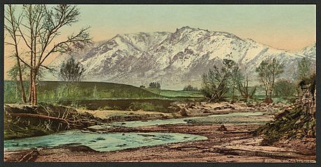
Cheyenne Mountain, around 1900

Early 1900s: New Developments
By 1905, the Colorado Springs and Cripple Creek District Railway crossed Cheyenne Mountain. It carried coal, mined ore, and passengers. A carriage road also went from Cheyenne Mountain to Seven Lakes and the top of Pikes Peak.
In 1904, Grace Lutheran Church built a retreat in Emerald Valley. This is now The Broadmoor's Ranch at Emerald Valley. In 1905, Dr. August McKay built a health resort called The Sunshine Inn. Spencer Penrose later bought this property and tore the inn down.
The Overlook Colony began in 1911. It was started by Colorado College professors as a summer retreat. It grew to include many interesting people. The Cheyenne Mountain Zoo was built below it. The Will Rogers Shrine was built above it. Residents of Overlook Colony manage their own water supply. It comes from deep inside the old Little Susie gold mine.
In 1917, Bert Swisher and Thomas Dixon claimed land on the mountain. Dixon lived in a cabin near the top. Swisher's cabin was near where the antenna farm is today.
Spencer Penrose: Shaping the Mountain
Cheyenne Mountain became a popular place for fun and relaxation thanks to Spencer Penrose. He opened The Broadmoor resort in 1918. The Cheyenne Mountain Cog Railroad offered train service to South Cheyenne Cañon from The Broadmoor. It later went to the Cheyenne Mountain Zoo. This service stopped in 1974.
In the 1920s, Penrose started developing land on the northern peak. He bought it in 1915. He built the Cheyenne Mountain Highway in 1925. In 1926, the Cheyenne Mountain Lodge opened at the top of the mountain. It had a restaurant and rooms for guests. Visitors could even ride elephants up the highway to the lodge! The lodge closed in 1961 and was torn down in 1976. Today, it's the site of The Broadmoor's Cloud Camp.
-

The Broadmoor resort, with Cheyenne Lake in the front and Cheyenne Mountain in the back

Penrose also built the country's highest zoo. The Cheyenne Mountain Zoo (1926) is about 6,800 feet (2,073 meters) high. He also built the Will Rogers Shrine of the Sun (1937). This shrine is on a northern point of the mountain. The Cheyenne Mountain Highway was built to reach the zoo, shrine, and mountain top. The Broadmoor also had a ski area on the mountain in 1959. It closed in 1991. Some land once owned by The Broadmoor was sold. Now, luxury homes stand there.
-
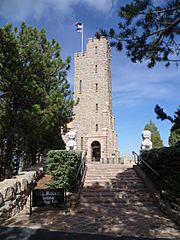
Will Rogers Shrine of the Sun
-
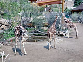
Giraffes at the Cheyenne Mountain Zoo


NORAD: The Mountain's Secret Base
In the 1950s, during the Cold War, the inside of Cheyenne Mountain became home to the operations center for NORAD. This center was finished in 1966. It cost $142 million and used 500 tons of explosives! It became an underground city run by the Air Force.
Popular Science magazine wrote in 1965 that Cheyenne Mountain was the only mountain known to have buildings built inside it. It was designed to survive a bomb attack. Eleven multi-story buildings stand on giant coil springs. These springs absorb the shock of an explosion. The facility was built so that up to 800 people could survive nuclear fallout. The buildings are covered in steel and surrounded by granite. Huge blast-proof doors protect the entrance. It was meant to be the "nerve center" for NORAD.
Canadian and United States military members worked at the NORAD center. Their job was to watch North American airspace. They looked for intercontinental ballistic missiles and Soviet military aircraft. During the Cold War, other military sites were also built nearby. These included the United States Air Force Academy, Peterson Air Force Base, and Fort Carson. After the Cold War, NORAD started watching objects orbiting Earth. They also tracked aircraft without flight plans. And, famously, they monitor Santa Claus's Christmas Eve journey!
NORAD used to offer public tours. But for security reasons, these stopped in 1999. Since September 11, 2001, Air Force Security Police have guarded the road to NORAD. Most of the center's operations moved to Peterson Air Force Base in 2006. However, in April 2015, the Pentagon announced that some operations would move back to Cheyenne Mountain.
-
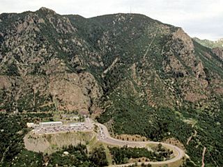
NORAD parking lot and antenna farm from above, 2011
-
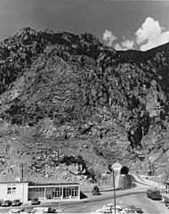
NORAD Entrance, Cheyenne Mountain, 1968
-
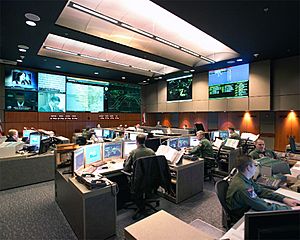
NORAD Command Center, United States Air Force photo


The Antenna Farm
In the 1950s, an antenna farm was built on the mountain's middle peak. Bert Swisher sold ten acres of land for this purpose. The Cheyenne Propagation Company opened a road to the area in 1960. Today, there are 700 transmitters on the antenna farm. These are for cell phones, television, radio, and law enforcement. The Cheyenne Mountain radio site covers a large area. It reaches from Monument almost to the New Mexico border.
Fun in Nature: Parks and Recreation
Cheyenne Mountain State Park
In 2000, the City of Colorado Springs and Colorado State Parks bought 1,680 acres of land. This was done to protect the mountain's southeastern side and its wildlife. This land, originally the JL Ranch, was planned for 2,500 new houses. The purchase created Cheyenne Mountain State Park. It is the only state park in El Paso County.
More land was added from 2007 to 2009. The park is now 2,701 acres in total. Part of it is at the base of the mountain, and part is on Cheyenne Mountain itself. The park has 20 miles (32 kilometers) of trails for hiking and exploring.
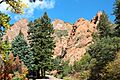
Cheyenne Cañon
North Cheyenne Cañon Park is a beautiful 1,600-acre area. It includes the Starsmore Discovery Center, Seven Falls, and fancy neighborhoods. North Cheyenne Creek starts in Teller County. South Cheyenne Creek also starts in Teller County, near Mount Big Chief. It flows through Seven Falls in South Cheyenne Cañon.
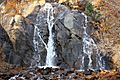
North Cheyenne Cañon Park began in 1885. The city of Colorado Springs bought 640 acres from Colorado College. General William Jackson Palmer donated another 480 acres. This land included High Drive, Silver Cascade Falls, and Helen Hunt Falls. In 1909, it was called "the grandest and most popular" canyon nearby. It's known for its evergreen trees, waterfalls, Cheyenne Creek, and cool rock formations. You can enjoy moderate hikes on trails like Mount Cutler and Columbine.
The two creeks, North and South Cheyenne, meet to form Cheyenne Creek. This happens near the intersection of North Cheyenne Canyon Road, South Cheyenne Canyon Road, and Cheyenne Boulevard.
Historic Trails
Two old trails lead to the top of Cheyenne Mountain. These are the Swisher and McNeil trails. They are not official and can be hard to see. At the end of the Swisher trail, you'll find a meadow and the remains of an old cabin. Most of the land at the top is public. However, the antenna farm, private property, and the road are restricted areas.
Images for kids
-
North Cheyenne Cañon Park
-
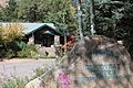
Starsmore Discovery Center, North Cheyenne Canon Park
-
Helen Hunt Falls


