Blue Hills Reservation Parkways facts for kids
Quick facts for kids |
|
|
Blue Hills Reservation Parkways-Metropolitan Park System of Greater Boston
|
|
 |
|
| Location | Quincy, Milton, Canton, and Braintree in Massachusetts |
|---|---|
| Area | 45 acres (18 ha) |
| Built | 1894 |
| Architect | Charles Eliot |
| MPS | Metropolitan Park System of Greater Boston MPS |
| NRHP reference No. | 03000746 |
| Added to NRHP | August 11, 2003 |

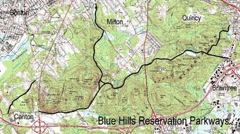
The Blue Hills Reservation Parkways are a group of old, scenic roads. They are found in and around the Blue Hills Reservation. This is a large state park just south of Boston. These roads help people get around the park. They also connect the park to other major roads like the Blue Hills Parkway.
A famous landscape architect named Charles Eliot designed most of these roads in the 1890s. One road, Green Street, was added later in the 1940s. Because of their history and design, these parkways were added to the National Register of Historic Places in 2003. This means they are important historical places worth protecting.
Contents
Exploring Blue Hills Parkways
The Blue Hills Reservation Parkways include six main roads. Some of these roads are split into different parts. They help you explore the beautiful Blue Hills Reservation. This park is managed by the Massachusetts Department of Conservation and Recreation (DCR).
Blue Hill River Road and Hillside Street
The first part of Blue Hill River Road starts in Canton. It meets Washington Street and Royall Street there. This section is about half a mile long. It then turns into Hillside Street when it reaches the Milton town line.
On one side, you'll see thick forest and rocky hills. On the other side, there's a sidewalk and a stone wall. This road also leads to Brookwood Farm, which is another property managed by the DCR.
Hillside Street: The Park's Main Road
Hillside Street is a very important road in the western part of the park. Many of the park's offices are located here. It winds for about 1.65 miles (2.66 km) through the middle of the park. You'll pass the park police headquarters and other buildings.
Further along, Hillside Street connects with other park roads. These include Unquity Road and Chickatawbut Road. It crosses Pine Tree Brook near the park's northern edge. The parkway part of the road ends here. However, the road continues as a regular street in Milton. It goes northeast until it meets Randolph Avenue.
Blue Hill River Road: Second Section
This part of Blue Hill River Road has two sections. They are at right angles to each other, but they used to be one long road. From its northern connection with Hillside Street, this road goes south. It runs along the edge of the reservation.
Soon, it reaches a three-way intersection. From here, Ponkapoag Trail goes south towards Interstate 93. Blue Hill River Road continues east into the reservation. It ends at a small circle near the southeastern part of Houghton's Pond. There's a parking area nearby. This area is great for picnics and playing sports. This whole section is about 0.87 miles (1.40 km) long.
Chickatawbut Road: Longest Parkway
Chickatawbut Road is the longest road in the Blue Hills Reservation. It stretches for almost 3.75 miles (6.04 km). It goes through Milton, Quincy, and Braintree. This winding road mostly offers views of dense woods.
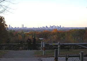
It starts at Unquity Road and Hillside Street in the west. It ends at Granite Street in Braintree. Chickatawbut Road also leads to the Chickatawbut Observation Tower. From this tower, you can see some of the best views in the entire reservation!
Green Street: A Later Addition
Green Street is a separate road from the others. It's on the western side of the reservation, in Milton and Canton. It runs from Royall Street in Canton northeast to Washington Street in Milton. It follows the very western edge of the park. This part of the reservation was bought in the 1940s. Green Street was originally a regular town street.
Unquity Road: Connecting the Park
Unquity Road goes north from where it meets Hillside Street and Chickatawbut Road. This is in the north-central part of the park. It curves along, roughly parallel to Pine Tree Brook. It's about 2.28 miles (3.67 km) long. It ends at a four-way intersection with Canton Street and the Blue Hills Parkway. This road was originally planned to be a southern extension of the Blue Hills Parkway.
Wampatuck Road: Eastern Access
Wampatuck Road is about 1 mile (1.6 km) long. It runs through the far eastern part of the park in Quincy. It starts where Chickatawbut Road turns more to the southeast. It ends at the Furnace Brook Parkway. This is a large traffic circle that connects to Interstate 93. Wampatuck Road also provides access to the Granite Railway, which is another property managed by the DCR.
 | Chris Smalls |
 | Fred Hampton |
 | Ralph Abernathy |


