Blue Hills Parkway facts for kids
Quick facts for kids |
|
|
Blue Hills Parkway
|
|
 |
|
| Location | Milton and Boston, Massachusetts |
|---|---|
| Area | 12 acres (4.9 ha) |
| Built | 1893 |
| Architect | Charles Eliot |
| MPS | Metropolitan Park System of Greater Boston MPS |
| NRHP reference No. | 03000574 |
| Added to NRHP | June 23, 2003 |
The Blue Hills Parkway is a special historic road. It connects different parks and natural areas. This parkway goes in a straight line from the Neponset River at the edge of Boston to the northern part of the Blue Hills Reservation in Milton, Massachusetts.
It was built in 1893. A famous landscape architect named Charles Eliot designed it. He also designed the beautiful areas along the Charles River. The Blue Hills Parkway links the Blue Hills Reservation and the Neponset River Reservation. Because of its history and design, it was added to the National Register of Historic Places in 2003.
Contents
What is the Blue Hills Parkway?
A parkway is a road designed to be scenic and often connects parks. The Blue Hills Parkway is about 1.5 miles (2.4 km) long. It helps people travel between two important natural areas. It also allows them to enjoy the scenery along the way.
Where Does the Parkway Go?
The northern end of the parkway is in Mattapan, a neighborhood in southern Boston. Here, several roads meet at a big intersection. These roads include River Street, Cummins Street, Blue Hill Avenue, and the road to the Mattapan MBTA station. Both Blue Hill Avenue and the parkway are part of Massachusetts Route 28 at this spot.
The parkway quickly crosses the Neponset River and enters Milton. Soon after, the Truman Parkway branches off to the west. Blue Hill Avenue (which is Massachusetts Route 138) goes southwest. A little further, Brook Road takes the Route 28 designation to the east.
The parkway then goes through a neighborhood with homes. It crosses a small stream called Pine Tree Brook. Finally, it reaches its southern end. This is an intersection with Canton Street and Unquity Road. Unquity Road is part of the Blue Hills Reservation Parkways.
How Was the Parkway Built?
The idea for the Blue Hills Parkway came about in 1894. It was one of the first connecting parkways designed by Charles Eliot and the Olmsted Brothers. They were famous for designing parks and landscapes.
Work to buy the land for the parkway started in 1896. Construction of the road itself happened in 1898. The bridge over the Neponset River was built a few years later, from 1901 to 1903.
Key Features of the Parkway
The Neponset River bridge is a major part of the parkway. It is made of granite and has three arches. Six lanes of traffic cross this bridge. On the south side of the bridge, the road has many lanes and landscaped areas. This helps cars turn easily.
In this area, the road has eight lanes. This allows for special turning lanes. You can also see an old granite mile marker from around 1823. It is in the grassy area on the west side of the road.
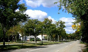
South of the Truman Parkway exit, the road becomes six lanes. After the Brook Road junction, it narrows to five lanes. The southern part of the parkway is very scenic. Trees line the middle of the road and both sides, creating a beautiful canopy overhead.
 | Shirley Ann Jackson |
 | Garett Morgan |
 | J. Ernest Wilkins Jr. |
 | Elijah McCoy |


