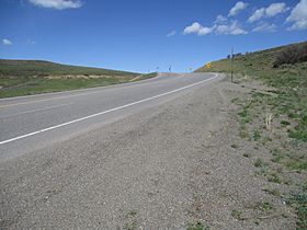
Blue Mesa Summit facts for kids
Quick facts for kids Blue Mesa Summit |
|
|---|---|

Blue Mesa Summit
|
|
| Elevation | 8,704 ft (2,653 m) |
| Traversed by | |
| Location | Gunnison County, Colorado |
| Coordinates | 38°23′10″N 107°26′01″W / 38.386220°N 107.433576°W |
| Topo map | USGS Curecanti Needle |
Blue Mesa Summit is a cool mountain pass in Colorado, like a special road that goes over a mountain! It's super high up, at 8,704 feet (that's about 2,653 meters) above sea level. Imagine driving over the top of a big hill that connects two valleys. That's what a mountain pass does! This pass is an important part of U.S. Route 50, a major highway that crosses the United States.
Contents
Where is Blue Mesa Summit?
Blue Mesa Summit is found in Gunnison County, which is in the western part of Colorado. It's a natural pathway through the mountains. The pass helps travelers get from one side of the mountains to the other.
How Does the Pass Help Water Flow?
This mountain pass does more than just help cars. It also divides two important water areas. To the west, water flows into Little Cimarron Creek. To the east, water flows into Blue Creek. This means the pass acts like a natural border for these water systems.
A Look Back in Time: History of the Pass
For a very long time, Blue Mesa Summit has been a key route for people traveling through Colorado.
Who Used the Pass First?
Long before cars and highways, the Utes used this pass. They are a Native American tribe who lived in this area. They traveled across the pass to move between different valleys.
Explorers and Trappers
Later, brave explorers and trappers also used Blue Mesa Summit. They were traveling between the Gunnison Valley to the east and the Uncompahgre Valley to the west. The pass was a vital link for their journeys.
Building a Road
By the 1870s, people realized how important this route was. So, they built a wagon road over the pass. This made it much easier for wagons and people to travel across the mountains. Today, that old wagon road has become part of the modern U.S. Route 50.
 | Audre Lorde |
 | John Berry Meachum |
 | Ferdinand Lee Barnett |


