
Blue Mounds State Park facts for kids
Quick facts for kids Blue Mounds State Park |
|
|---|---|

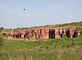
Sioux Quartzite bedrock in Blue Mounds State Park
|
|

Blue Mounds State Park
Location in Minnesota

Blue Mounds State Park
Location in the United States
|
|
| Location | Rock, Minnesota, United States |
| Area | 1,567 acres (6.34 km2) |
| Elevation | 1,608 ft (490 m) |
| Established | 1937 |
| Governing body | Minnesota Department of Natural Resources |
|
Blue Mounds State Park WPA/Rustic Style Historic Resources
|
|

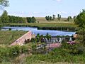
Upper Dam and Upper Mound Lake, constructed 1938
|
|
| Location | Mound Township |
| Area | 60 acres (24 ha) |
| Built | 1937–1942 |
| Architect | National Park Service, Minnesota Division of Drainage & Waters, Works Progress Administration |
| Architectural style | NPS Rustic |
| MPS | Minnesota State Park CCC/WPA/Rustic Style MPS |
| NRHP reference No. | 89001657 |
| Added to NRHP | 1989-10-25 |
Blue Mounds State Park is a special place in Minnesota, USA. It's located in Rock County, close to the town of Luverne. This park helps protect a herd of American bison (also known as buffalo). These bison graze on one of the biggest remaining prairie areas in the state.
The park gets its name from a long, steep cliff made of very old, hard pink rock called Sioux Quartzite. Early settlers thought this rock looked blue from far away. Parts of this cliff are as tall as 100 feet (30 m)! It's quite unusual to see such a cliff in the flat prairie. Because of its unique features, it's a popular spot for rock climbing.
Blue Mounds State Park also has an ancient line of rocks, about 1,250-foot-long (380 m). Native Americans from the Plains Indians tribes arranged these rocks. They used them to mark where the sun rises and sets during the spring and fall equinoxes. An equinox is when day and night are about equal in length. The park also has a small human-made lake (called a reservoir) where you can swim. It's the only lake in Rock County! The park's visitor center used to be the home of a famous author named Frederick Manfred.
Some buildings and structures in the park were built in the 1930s by the Works Progress Administration (WPA). These historic sites are now listed on the National Register of Historic Places.
Contents
Animals of Blue Mounds State Park
This park is home to many different animals. You might see a small number of coyotes and deer. It's also a great place for birdwatching, with many different kinds of birds living here.
The Park's Bison Herd

The park's bison herd started in 1961. They bought three bison from a wildlife refuge in Nebraska. Today, there are over 100 bison living in the park! To keep the herd healthy and natural, some bison are sold each fall. This helps manage their numbers. The area where the bison live is fenced off. Visitors are always warned to stay away from the fence if the bison are nearby. These animals are very strong and can be unpredictable.
History of the Park
Local stories say that the "mound" (the big rock formation) was once used as a "buffalo jump" by Native Americans. A buffalo jump is a cliff where hunters would guide bison to fall, making it easier to hunt them. However, scientists haven't found any proof of this yet. The soil on the mound was too thin and rocky for farming, so it was never plowed. This helped save the natural prairie.
The park land was first set aside in 1937. This was during the Great Depression, and the goal was to create jobs and provide a place for water activities. WPA workers built two dams on Mound Creek. These dams created two lakes: Upper Mound Lake (18 acres (7.3 ha)) and Lower Mound Lake (28 acres (11 ha)). They also built picnic areas and a beach house. The area, then called Mound Springs Recreational Reserve, opened in 1937. In the 1950s, trees were planted around the lakes and camping areas.

More land was added to the park in 1955 and 1961. That's when its name officially changed to Blue Mounds State Park. Even more land was added later to include the entire Blue Mound and surrounding areas. In 1972, the state bought the house of author Frederick Manfred to turn it into a visitor center. He was allowed to live there for three more years.
The house was at one end of the mound, and the main park area was at the other. There was a plan to build a road connecting them across the top of the mound. But local groups who cared about nature stopped this plan many times in the 1970s. They worried about the damage it would do to the environment on top of the mound. So, in 1986, a road was built from the house south to a county highway instead. This means visitors to the interpretive center either hike from the north or drive around the park to the south entrance.
In 1989, the WPA buildings and structures were recognized as a historic district on the National Register of Historic Places. This district covers about 60-acre (24 ha). It includes five important parts: Upper Dam, Upper Mound Lake, Lower Dam, Lower Mound Lake (all built in 1938), and a restroom building (built 1939–42). These are important because they show how federal work programs helped during the New Deal era. They also show a unique building style called National Park Service rustic, which uses local Sioux Quartzite rock. The two dams are especially cool because they blend right into the natural rock walls of the creek.
Images for kids
-
Sioux Quartzite bedrock in Blue Mounds State Park
-
Upper Dam and Upper Mound Lake, constructed 1938
-

Bison herd in the park in spring
-
The Frederick Manfred House
See also
 In Spanish: Parque estatal Blue Mounds para niños
