Blue Water River Walk facts for kids
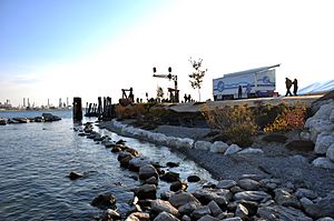
The Blue Water River Walk is a beautiful place to explore along the St. Clair River in Port Huron, Michigan. It's almost one mile long! You can find it near the famous Blue Water Bridge, which connects Michigan to Sarnia, Canada. This special area has a natural shoreline with rocks and pebbles. You'll also see lots of native plants, flowers, trees, and shrubs growing here. It's a great spot for nature to thrive. Visitors can walk along the shore, look for turtles, have a picnic, and watch huge freighters pass by.
Contents
How the River Walk Was Created
The Blue Water River Walk is owned by the Community Foundation of St. Clair County. This foundation works through one of its groups called the Blue Water Land Fund.
The land for the River Walk was a gift from James and Suzanne Acheson in 2011. They are local people who like to give back to their community. In return for their gift, the Foundation promised to raise money to fix up the shoreline. They also promised to make sure the River Walk would always be open to the public. So, it's like a public park for everyone to enjoy!
This land is over 70 acres of prime waterfront property. It's known as Desmond Landing. This area also hosts a maritime center, a farmers' market in the summer, and special events like fireworks.
The Blue Water River Walk has cool features like offshore reefs and new homes for wildlife. There's also a restored ferry dock and a walking path. St. Clair County Parks is even building a wetlands area at the south end. The City of Port Huron has also connected the River Walk trail to the longer Bridge to Bay Trail.
In 2012, a special ceremony was held to start the project. Important officials, including Senator Debbie Stabenow and Congresswoman Candice Miller, showed their support. The River Walk officially opened to the public on June 7, 2014.
The Community Foundation of St. Clair County started way back in 1944. Today, it's the biggest foundation that gives grants in Michigan's Thumb Region. It helps people manage their charitable giving.
What Can You See and Do?
Amazing Offshore Reefs
One of the most interesting things you'll see at the Blue Water River Walk are the huge stone structures in the water. These are called offshore reefs. They stick up from the water just a little bit. These reefs go down almost 15 feet into the river bottom! The big rocks you see on top can weigh as much as 4,000 pounds. They sit on two other layers: recycled cement slabs at the very bottom, and smaller rocks in the middle. In total, over 8,000 tons of rock, stone, and cement were used to build these reefs.
These offshore reefs are super important for making the St. Clair River shoreline more natural. They do two main things:
- First, they help break down the strong waves from passing boats. Without them, those waves could really damage the new plants and habitats along the shore.
- Second, they create new shallow water habitats between the reefs and the shoreline. This shallow water is perfect for small fish, reptiles, and amphibians to grow and develop. Many parts of the upper St. Clair River didn't have enough shallow water for wildlife. These reefs have helped create new homes for animals along almost one mile of the shoreline.
Wildlife Habitats
Many natural features have been added to the shoreline to help wildlife. These include new plant areas, special logs for turtles to bask in the sun, dens for snakes, and bird houses. Since summer 2015, visitors can also explore a natural wetlands park at the southern end of the River Walk. This large area is managed by St. Clair County Parks & Recreation.
Restored Ferry Dock
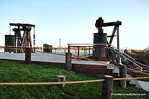
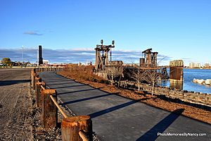
Along the Blue Water River Walk, you'll find an old railroad ferry dock. This dock has been completely fixed up and is now a great place to view the St. Clair River. The walking surface is made of Brazilian walnut wood. New railings, lights, and stairs have also been added. An old, working railroad signal light welcomes visitors to the ferry dock.
Pedestrian Trail for Walking and Biking
A wide, 10-foot asphalt trail runs the entire length of the Blue Water River Walk. For safety, special posts called bollards have been placed along the side of the trail. These posts stop vehicles from driving onto the path. Interestingly, these posts came from the old ferry dock! They were cut down in 2013, and the old posts were reused for the trail.
This trail is a very important part of the larger Bridge to Bay Trail. This longer trail stretches for more than 50 miles, from Lakeport State Park to New Baltimore.
Fishing Pier
A fishing pier was added to the River Walk in June 2015. The first part of the pier opened to the public on July 4, 2015. This pier lets people cast their fishing lines 65 feet away from the shore. A second part of the pier will be added later.
Public Art to Enjoy
In the summer of 2014, two pieces of public art were added to the River Walk. They help tell the history of the Blue Water Area and make the walk even more fun for visitors.
- Stella Clair is a 1,500-pound metal sturgeon fish. It was made by Michigan artist Lou Rodriquez. Lake sturgeon are large fish that can weigh between 30 and 100 pounds. There are about 30,000 adult sturgeon living near the mouth of the St. Clair River. Nine reefs were put in the middle of the St. Clair River to give sturgeon places to lay their eggs. This helps increase the fish population in the river.
- Sugar, the Iron Horse is another piece of public art installed in 2014. Sugar is a 7-foot-tall horse created by artist James Oleson. Oleson is a sculptor and painter from Florida, and his artwork can be found all over the United States.
 | Selma Burke |
 | Pauline Powell Burns |
 | Frederick J. Brown |
 | Robert Blackburn |


