
Boca Chica Key facts for kids

Boca Chica Key
Location in Florida

Boca Chica Key
Location in Caribbean
|
|
| Geography | |
|---|---|
| Location | Gulf of Mexico |
| Coordinates | 24°34′39″N 81°41′36″W / 24.5774°N 81.6933°W |
| Archipelago | Florida Keys |
| Adjacent bodies of water | Florida Straits |
| Administration | |
| State | Florida |
| County | Monroe |
Boca Chica Key is a cool island in the Florida Keys. It's located in the lower part of the Keys. This island is about 1.6 kilometers (1 mile) east of Key West. Its name comes from the Spanish words for "small mouth."
Contents
What is Boca Chica Key Like?
Boca Chica Key is mostly covered by salt marshes. These are wetlands where salty water flows in and out. You'll also find many mangrove trees there. Mangroves are special trees that can grow in saltwater.
This island is very important for the United States Navy. It is home to the largest Naval Air Station in south Florida. This base is called NAS Key West. It's a busy place where military aircraft operate.
Getting Around the Island
U.S. 1 crosses Boca Chica Key. This highway is also known as the Overseas Highway. It runs from about mile marker 6.5 to 8 on the island. This part of the highway is east of Key West. You can find the NAS Key West base and Boca Chica Beach (also called Geiger Beach) along Boca Chica Road.
Images for kids
-
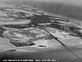
Boca Chica Key, April 1940
-
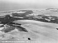
Boca Chica Key, April 1940
.jpg)
.jpg)
See also
 In Spanish: Cayo Boca Chica para niños
