Boddington, Western Australia facts for kids
Quick facts for kids BoddingtonWestern Australia |
|||||||||||||||
|---|---|---|---|---|---|---|---|---|---|---|---|---|---|---|---|

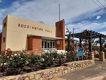
The heritage listed Boddington Town Hall
|
|||||||||||||||
| Postcode(s) | 6390 | ||||||||||||||
| Area | [convert: needs a number] | ||||||||||||||
| Location | |||||||||||||||
| LGA(s) | Shire of Boddington | ||||||||||||||
| State electorate(s) | Central Wheatbelt | ||||||||||||||
| Federal Division(s) | O'Connor | ||||||||||||||
|
|||||||||||||||
Boddington is a town and shire in the Peel region of Western Australia. It is located about 120 kilometers (75 miles) southeast of Perth. The town is built along the Hotham River, on the road that connects Pinjarra to Williams. In 2016, about 1,844 people lived in Boddington.
Contents
Boddington's Early History
The town of Boddington gets its name from an early settler named Henry Boddington. He was a farmer and shepherd in the 1860s and 1870s. Henry Boddington often camped by a special pool in the Hotham River. This pool became known by his name.
The first settlement in the area was called Hotham. It was about 2 kilometers (1.2 miles) west of where the town is today. A post office and a school were set up there.
How the Town Grew
In 1912, a railway was being built to help the local timber industry. A new town site was chosen next to the railway line. This new town was officially created.
During the 1920s, Boddington grew with new buildings. These included a school, a hospital, and shops. A railway bridge was built over the Murray River in 1949. This bridge helped transport timber for sawmills.
Changes Over Time
Over the years, the area slowly became less busy. In 1961, big bushfires damaged the timber industry. By 1969, the railway had closed down. Boddington became a small town that served the nearby farms.
However, things changed in 1979 when bauxite mining started. Bauxite is a rock used to make alumina, which is then used to make aluminum. Then, in 1987, the Boddington Gold Mine opened. These mines helped Boddington become a busy mining town.
What is Boddington Like Today?
Boddington is about 11 kilometers (7 miles) off the Albany Highway. It is located in the Darling Scarp area. Today, Boddington is a center for sheep farming and timber. It also provides services for the nearby bauxite and gold mines.
The town has a TAFE center, which is a college for vocational training. Every year, on the first weekend of November, Boddington hosts a big 3-day rodeo. You can also find a high school, shops, and places to stay like a hotel or caravan park.
People and Culture
In the 2016 Census, there were 1,198 people living in Boddington. Most people, about 74.1%, were born in Australia. English was the main language spoken at home by 87.3% of the people.
Exploring the District
Near the town, there is a special plaque that marks the grave of an Aboriginal man named Quency Dilyan. He helped explorers Alexander Forrest and H.S. Ranford on their trips in the area. The local council has also created scenic drives and walking trails. These go through state forests and areas with beautiful wildflowers.
How Boddington Makes Money
The town's economy mainly relies on mining and farming. The Shire of Boddington is home to two important mines. One is the Newmont Mining owned Boddington Gold Mine. The other is the South32 operated Boddington Bauxite Mine.
Because of these mining activities, Boddington is growing quickly. Experts believe the town's population could double soon. This means more homes will be needed for new residents. Several new housing areas are being built, like Huntley Rise Estate and Forrest Hill Estate.
Places to Stay
If you visit Boddington, there is self-contained accommodation available. It is called Boddington Retreat and is located right in the middle of town.
Important Mines
 | Emma Amos |
 | Edward Mitchell Bannister |
 | Larry D. Alexander |
 | Ernie Barnes |


