
Bodegraven facts for kids
Quick facts for kids
Bodegraven
|
|||
|---|---|---|---|
|
Town
|
|||

Windmill De Arkduif
|
|||
|
|||

Bodegraven
Location in South Holland

Bodegraven
Location in Netherlands
|
|||
| Country | Netherlands | ||
| Province | South Holland | ||
| Municipality | Bodegraven-Reeuwijk | ||
| Area | |||
| • Total | 26.58 km2 (10.26 sq mi) | ||
| Elevation | 0.7 m (2.3 ft) | ||
| Population
(2021)
|
|||
| • Total | 19,280 | ||
| • Density | 725.4/km2 (1,878.7/sq mi) | ||
| Time zone | UTC+1 (CET) | ||
| • Summer (DST) | UTC+2 (CEST) | ||
| Postal code |
2411
|
||
| Dialing code | 0172 | ||


Bodegraven (Dutch pronunciation: [ˈboːdəˌɣraːvə(n)]) is a town in the western Netherlands. It is located in the province of South Holland. The town used to be its own municipality, which is like a local government area.
The former municipality of Bodegraven also included smaller communities. These were places like Meije and Nieuwerbrug. In 2011, Bodegraven joined with Reeuwijk. Together, they formed a new, larger municipality called Bodegraven-Reeuwijk.
Contents
Exploring Bodegraven's Location
Bodegraven is right in the middle of the "Green Heart" area of the Randstad. The Randstad is a large urban region in the Netherlands. Bodegraven is about 30 kilometers away from major cities. These cities include Amsterdam, Rotterdam, The Hague, and Utrecht.
The town is built on both sides of the Oude Rijn river. There are even locks in the middle of the town. The oldest part of Bodegraven is on the north side of the river. Here you can find the Reformed St. Gallus Church.
A Look Back at Bodegraven's History
Bodegraven has a very long history. People lived here even during the Roman Era. It was part of the Roman Empire's northern border, known as the Limes Germanicus. The Romans built many army camps, ports, and roads in this area. Many settlements, including Bodegraven, grew up along these Roman roads.
Early Settlements and Medieval Times
Not much is known about Bodegraven right after the Roman times. Some old stories say a map from 809 mentioned a place called "Bodelo." We do know for sure that by about 1050, a small settlement had formed. This was probably near where the current Village Church stands today.
For two centuries, there were arguments over who controlled Bodegraven. The bishop of Utrecht and the Counts of Holland both wanted it. In the end, Bodegraven became part of Holland.
Shaping the Land: Ditches and Locks
In the late Middle Ages, people started to prepare large areas around Bodegraven for farming. They dug special ditches called kavelsloten. These ditches ran straight out from rivers like the Oude Rijn and Meije. Then, they dug other ditches across, about 1250 meters from the rivers. These were called achtersloten. This way of digging created the unique grid pattern you can still see in the fields today. Around 1350, a lock was built in Bodegraven to control water levels.
War and Rebuilding
In 1672, a big war started involving the Dutch Republic, England, France, and others. Bodegraven was just behind the Water Defense Line. This was a flooded area designed to stop enemy troops. In winter, the French army could march over the frozen fields. They reached places like Meije and Zwammerdam. The Dutch army managed to push them back before they reached Alphen aan den Rijn.
When the ice melted, the French had to retreat along the dike of the Oude Rijn. They passed through Bodegraven and destroyed much of the town. After this, a fort called Wierickerschans was built just east of Bodegraven.

Bodegraven grew and did well until 1870. But that year, a fire started in a bakery. The fire spread and burned down a large part of the town. About 100 homes were destroyed, and 130 families lost their homes. People from all over the country helped by collecting money. The town quickly recovered and rebuilt itself.
In the 20th century, Bodegraven continued to grow. New areas were built up, first on the south side, then the north side, and later between the railway and the A12 Motorway.
Bodegraven's Economy and Industries
Bodegraven is well-known for its cheese trade. The powerful Goebel family used to control much of this business. While there are fewer cheese warehouses now, and the Tuesday Cheese Market stopped in 2001, you can still find a cheese museum and a cheese monument near the church.
The town was also famous for shampoo because of the Andrélon Factory. This factory was started in the 1940s by a barber named André de Jong. However, the factory closed down in 2005 and was later taken apart.
Bodegraven is in a good spot in the "Green Heart" region. This means many different types of businesses and industries are located here.
There is also a beautiful old windmill in the town. It was built in the late 1600s and is now called "De Arkduif." This windmill is home to a small brewery called Brouwerij De Molen.
Getting Around Bodegraven
Road Connections
The A12 Motorway runs right next to Bodegraven. This highway connects The Hague to the German border, passing through Utrecht and Arnhem. The N11 State Highway links the A12 with the A4 Motorway near Leiden.
Train Travel
Bodegraven has its own railway station: Bodegraven. Trains run between Leiden and Utrecht, stopping in Bodegraven. You can catch a train four times every hour.
Bus Services
There is one main bus line (Line 178) in Bodegraven. It connects the town with Reeuwijk and Gouda. A local bus (Line 724) travels between Bodegraven, Zwammerdam, De Meije, Zegveld, Woerden, and Nieuwerbrug. Another local bus (Line 722) links Alphen aan den Rijn and Bodegraven via Zwammerdam. A steam tram used to run between Bodegraven and Gouda. From 1892 to 1917, horses pulled the tram instead of steam engines.
Notable People from Bodegraven
- Wyco de Vries - A water polo player who competed in the 1996 Summer Olympics.
Images for kids
-
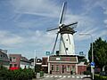
Windmill De Arkduif
-

Flag of Bodegraven
-
Coat of arms of Bodegraven
See also
 In Spanish: Bodegraven para niños
