Bogard, Missouri facts for kids
Quick facts for kids
Bogard, Missouri
|
|
|---|---|

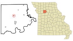
Location of Bogard, Missouri
|
|
| Country | United States |
| State | Missouri |
| County | Carroll |
| Area | |
| • Total | 0.55 sq mi (1.41 km2) |
| • Land | 0.55 sq mi (1.41 km2) |
| • Water | 0.00 sq mi (0.00 km2) |
| Elevation | 866 ft (264 m) |
| Population
(2020)
|
|
| • Total | 167 |
| • Density | 305.86/sq mi (118.17/km2) |
| Time zone | UTC-6 (Central (CST)) |
| • Summer (DST) | UTC-5 (CDT) |
| ZIP code |
64622
|
| Area code(s) | 660 |
| FIPS code | 29-06832 |
| GNIS feature ID | 2394213 |
Bogard is a small city located in Carroll County, Missouri, in the United States. In 2020, the population of Bogard was 167 people. It is a quiet place with a rich history.
Contents
History of Bogard
Bogard was first known as Bogard's Mound. This name came from a small hill, or tumulus, nearby. A pioneer citizen named Bogard used this hill as a lookout point.
The official plan for the village was created in 1884. Before that, a post office opened in 1872. It was called Bogard Mound. In 1884, the name was shortened to just Bogard.
Where is Bogard Located?
Bogard is in Carroll County, Missouri. The United States Census Bureau says the city covers about 0.55 square miles (1.41 square kilometers). All of this area is land, with no water.
Who Lives in Bogard?
This section looks at the people who live in Bogard and how the population has changed.
Population Changes Over Time
The number of people living in Bogard has changed over the years. Here's a look at the population from 1890 to 2020:
| Historical population | |||
|---|---|---|---|
| Census | Pop. | %± | |
| 1890 | 300 | — | |
| 1900 | 276 | −8.0% | |
| 1910 | 316 | 14.5% | |
| 1920 | 381 | 20.6% | |
| 1930 | 329 | −13.6% | |
| 1940 | 334 | 1.5% | |
| 1950 | 285 | −14.7% | |
| 1960 | 277 | −2.8% | |
| 1970 | 294 | 6.1% | |
| 1980 | 285 | −3.1% | |
| 1990 | 228 | −20.0% | |
| 2000 | 234 | 2.6% | |
| 2010 | 164 | −29.9% | |
| 2020 | 167 | 1.8% | |
| U.S. Decennial Census | |||
A Look at the People in 2010
In 2010, there were 164 people living in Bogard. These people lived in 74 different homes. The city had about 298 people per square mile.
Most of the people in Bogard (100%) were White. About 3.7% of the population identified as Hispanic or Latino.
Many homes (56.8%) had married couples living together. About 24.3% of homes had children under 18. The average home had 2.22 people.
The average age of people in Bogard was 45.5 years old. About 18.9% of residents were under 18. Also, 23.2% were 65 years old or older. The population was 47.0% male and 53.0% female.
Schools in Bogard
Students in Bogard attend schools in the Carrollton R-VII School District.
See also
 In Spanish: Bogard (Misuri) para niños
 | James Van Der Zee |
 | Alma Thomas |
 | Ellis Wilson |
 | Margaret Taylor-Burroughs |

