Bollons Seamount facts for kids

The Bollons Seamount (also called Bollons Tablemount) is a large underwater mountain. It is located in the Pacific Ocean, east of the International Date Line. This seamount is found a few hundred miles off the coast of New Zealand.
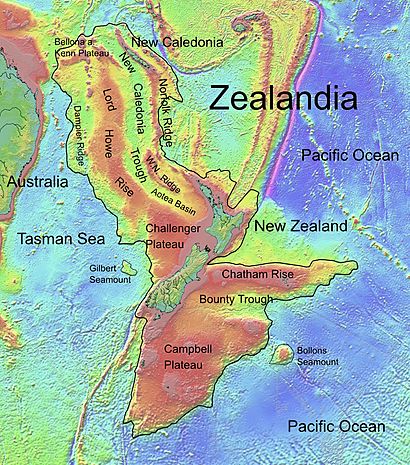
A seamount is like a mountain on land, but it is completely underwater. Bollons Seamount is special because it is a continental fragment. This means it is a piece of land that broke off from a larger continent. In this case, it separated from Zealandia, which is mostly submerged continent. This separation happened because of a process called rifting, where the Earth's crust pulls apart.
Contents
What is Bollons Seamount?
Bollons Seamount is an underwater mountain that rises from the seafloor. It is not an island because its top is still below the ocean surface. Scientists sometimes call it a "tablemount" because its top is flat, like a table.
This seamount is a piece of the ancient continent of Zealandia. Zealandia is a large landmass that sank beneath the waves millions of years ago. Bollons Seamount broke away from Zealandia when the Earth's crust stretched and split apart.
Studying the Seamount
Scientists have studied Bollons Seamount to learn more about the Earth's history. In 2002, a special survey was done there. The goal was to find the exact edge of New Zealand's continental shelf. The continental shelf is the underwater land that extends from a continent's coast.
How it Formed
Bollons Seamount was a very active place during the Cretaceous period. This was about 80 million years ago. During this time, the Earth's plates were moving a lot. Plate tectonics is the scientific theory that explains how large pieces of the Earth's outer layer move.
The movement of these plates caused a lot of rifting in the area. Rifting is when the Earth's crust pulls apart, often creating new ocean floor. This happened near the southern Chatham Rise, an underwater ridge.
Clues from Magnetism
Scientists use magnetic anomalies to understand how the seamount formed. Magnetic anomalies are unusual patterns in the Earth's magnetic field. These patterns show that the rifting around Bollons Seamount was very uneven. The land pulled apart differently in various spots.
There is a gap near the seamount, about 50 km (31 mi) wide. It is called the Bollons gap. Scientists believe this gap formed because of extra seafloor spreading. Seafloor spreading is when new ocean crust is created as plates move apart. This process often involves volcanoes.
Nearby Features
South of Bollons Seamount is a ridge called the Antipodes Fracture Zone. This ridge formed from a mix of forces. It was built by both squeezing (compression) and volcanic activity. These forces are linked to a nearby triple-junction plate boundary. A triple junction is a spot where three tectonic plates meet. In this case, it was where the Bellingshausen Plate and Marie Byrd Land plate met.

