Bolton, New York facts for kids
Quick facts for kids
Bolton
|
|
|---|---|
| The Village of Bolton | |

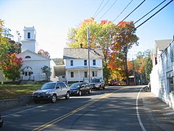
Neighborhood in Bolton Landing
|
|

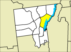
Location of Bolton in Warren County
|
|
| Country | United States |
| State | New York |
| County | Warren |
| Area | |
| • Total | 90.04 sq mi (233.21 km2) |
| • Land | 63.27 sq mi (163.88 km2) |
| • Water | 26.77 sq mi (69.32 km2) |
| Elevation | 758 ft (231 m) |
| Population
(2010)
|
|
| • Total | 2,326 |
| • Estimate
(2016)
|
2,278 |
| • Density | 36.00/sq mi (13.90/km2) |
| Time zone | UTC-5 (Eastern (EST)) |
| • Summer (DST) | UTC-4 (EDT) |
| FIPS code | 36-07234 |
| GNIS feature ID | 0978741 |
Bolton is a lovely town located in Warren County, New York, United States. It's part of the Glens Falls Metropolitan Statistical Area, which is a group of nearby cities and towns. In 2000, about 2,117 people lived here. Bolton is found on the eastern edge of Warren County.
Contents
Discovering Bolton's Past
The first people started settling in the Bolton area around the year 1792.
How Bolton Became a Town
The village of Bolton was officially created in 1799. It was formed from a part of another town called Thurman. Over time, Bolton gave up some of its land as three new towns were created in the county.
Who Was Bolton Named After?
This town is named after a person named Robert “Bob” Bolton. He moved to the area in 1788 with his wife, Margaret.
Historic Places in Bolton
Some important historical sites in Bolton are recognized nationally. The Cadet, which is a shipwreck, was added to the National Register of Historic Places in 2002. The Gates Homestead, an old home, was added to the list in 2010.
Exploring Bolton's Geography
Bolton covers a total area of about 90.1 square miles (233.2 square kilometers). Most of this area, about 63.4 square miles (163.8 square kilometers), is land. The rest, about 26.7 square miles (69.3 square kilometers), is water, making up almost 30% of the town's total area.
Bolton's Location and Natural Beauty
The eastern border of Bolton is along the eastern shore of Lake George. This lake also forms the border with Washington County. Bolton is also located within the beautiful Adirondack Park, a large protected natural area.
Roads and Mountains in Bolton
NY 9N is a main road that runs along the western shore of Lake George. It connects the important communities in Bolton. Interstate 87, also known as the Northway, runs along the western edge of the town.
The highest point in Bolton is Five Mile Mountain. It stands tall at 2,256 feet (688 meters) and is part of the Tongue Mountain Range. The lowest point is the surface of Lake George, which is about 320 feet (98 meters) above sea level.
Bolton's Population Over Time
| Historical population | |||
|---|---|---|---|
| Census | Pop. | %± | |
| 1820 | 1,087 | — | |
| 1830 | 1,466 | 34.9% | |
| 1840 | 937 | −36.1% | |
| 1850 | 1,147 | 22.4% | |
| 1860 | 1,289 | 12.4% | |
| 1870 | 1,135 | −11.9% | |
| 1880 | 1,132 | −0.3% | |
| 1890 | 1,387 | 22.5% | |
| 1900 | 1,363 | −1.7% | |
| 1910 | 1,518 | 11.4% | |
| 1920 | 1,184 | −22.0% | |
| 1930 | 1,308 | 10.5% | |
| 1940 | 1,310 | 0.2% | |
| 1950 | 1,184 | −9.6% | |
| 1960 | 1,417 | 19.7% | |
| 1970 | 1,589 | 12.1% | |
| 1980 | 1,793 | 12.8% | |
| 1990 | 1,855 | 3.5% | |
| 2000 | 2,117 | 14.1% | |
| 2010 | 2,326 | 9.9% | |
| 2016 (est.) | 2,278 | −2.1% | |
| U.S. Decennial Census | |||
According to the census from 2000, there were 2,117 people living in Bolton. These people made up 941 households, and 628 of those were families. The population density was about 33.4 people per square mile (12.9 people per square kilometer).
Who Lives in Bolton?
The people living in Bolton come from different backgrounds. Most residents are White. There are also smaller groups of African American, Native American, and Asian residents. Some people identify with two or more races. A small percentage of the population is Hispanic or Latino.
Age Groups in Bolton
The population in Bolton includes people of all ages. About 19.4% of the residents are under 18 years old. About 19.4% are 65 years old or older. The average age in Bolton was 46 years old in 2000.
Communities and Places in Bolton
Bolton has several interesting communities and natural spots:
- Basin Bay – A bay located south of the main Bolton hamlet.
- Bolton – This is a hamlet (a small community) right on the shore of Lake George, along Route 9N.
- Bolton Landing – This is the biggest community in the town. It's also on the shore of Lake George, along Route 9N.
- Boon Bay – Another bay on Lake George, close to the southern border of the town.
- Cat Mountain – A mountain located in the southwestern part of the town.
- Green Island – An island in Lake George, located near Bolton Landing.
- Huddle Bay – A bay situated between the Bolton hamlet and Bolton Landing.
- North Bolton – A hamlet found northwest of Bolton Landing.
- Northwest Bay – A bay in Lake George, located north of Bolton Landing.
- Riverbank – A hamlet on the western edge of the town.
- Tongue Mountain Range – A series of mountains that form a peninsula reaching into Lake George. This range helps create Northwest Bay. It has five main peaks: Brown Mountain, Fivemile Mountain, Fifth Peak, French Point Mountain, and First Peak.
- Trout Lake – A beautiful lake located in the south-central part of the town.
See also
 In Spanish: Bolton (Nueva York) para niños
 | Sharif Bey |
 | Hale Woodruff |
 | Richmond Barthé |
 | Purvis Young |


