Booie, Queensland facts for kids
Quick facts for kids BooieKingaroy, Queensland |
|||||||||||||||
|---|---|---|---|---|---|---|---|---|---|---|---|---|---|---|---|

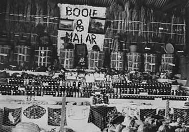
Booie and Malar districts exhibition at Kingaroy Show, 1936
|
|||||||||||||||
| Population | 1,094 (2021 census) | ||||||||||||||
| • Density | 7.753/km2 (20.08/sq mi) | ||||||||||||||
| Established | 1877 | ||||||||||||||
| Postcode(s) | 4610 | ||||||||||||||
| Area | 141.1 km2 (54.5 sq mi) | ||||||||||||||
| Time zone | AEST (UTC+10:00) | ||||||||||||||
| Location | |||||||||||||||
| LGA(s) | South Burnett Region | ||||||||||||||
| State electorate(s) | Nanango | ||||||||||||||
| Federal Division(s) | Maranoa | ||||||||||||||
|
|||||||||||||||
Booie is a rural area in Queensland, Australia. It is part of the South Burnett Region. In 2021, about 1,094 people lived in Booie. It is known for its quiet, country feel.
Contents
What is Booie Like?
Booie is a large rural area. It has two smaller parts, or neighbourhoods, within it.
Hillsdale Neighbourhood
Hillsdale is a neighbourhood in the southern part of Booie. You can find it at 26°33′00″S 151°56′00″E / 26.55°S 151.9333°E.
Redvale Neighbourhood
Redvale is another neighbourhood. It is located in the south-west of Booie. Its coordinates are 26°32′23″S 151°53′25″E / 26.5396°S 151.8904°E.
A Look Back in Time
The name Booie comes from a local Indigenous language. It is believed to be a Wakawaka language word. The word means carpet snake.
Early Days
People started to choose land in Booie in 1877. This meant they could settle and farm the land. A large area, about 54 square miles, was available.
Booie's Schools
Booie had several schools over the years:
- Booie Provisional School opened in September 1892. It became Booie State School in 1905. This school closed around 1963. It was located at 1015 Booie Crawford Road (26°29′52″S 151°55′43″E / 26.49772°S 151.92865°E).
- Three Mile State School opened on June 1, 1911. It was soon renamed Redvale State School. This school closed around 1939. It was on the north-east corner of Kingaroy Barkers Creek Road and Redvale Road (26°32′24″S 151°53′21″E / 26.53998°S 151.88913°E).
- Hillsdale State School opened on November 23, 1916. It closed and reopened a few times. It finally closed for good on December 31, 1966. This school was at 6 Mcauliffes Road (26°32′37″S 151°56′30″E / 26.54348°S 151.94167°E).
Who Lives in Booie?
In 2021, Booie had a population of 1,094 people. This number has grown over the years. In 2011, there were 912 people. By 2016, the population was 1,040.
Learning in and Around Booie
Booie does not have any schools right now. Students attend schools in nearby towns.
Primary Schools Nearby
- Coolabunia State School in Coolabunia (south)
- Taabinga State School in Kingaroy (south-west)
- Kingaroy State School in Kingaroy (west)
- Crawford State School in Crawford (west)
- Wooroolin State School in Wooroolin (north-west)
- Nanango State School in Nanango (south-east)
Secondary Schools Nearby
- Kingaroy State High School in Kingaroy
- Nanango State High School in Nanango
Important Places
Booie Cemetery
The Booie Cemetery is a local burial ground. It is located on Radunza Road. This road is off the Kingaroy-Barkers Creek Road. You can find it at 26°31′09″S 151°56′03″E / 26.5192°S 151.9341°E.
The Booie Monster Mystery
In June 1954, Booie became famous for a strange story. Some local boys said they saw a two-legged monster. They claimed it was hiding in a cave. People searched for the creature. Even experienced bushmen looked for it. However, the monster was never found. Many people thought the boys might have seen a very large kangaroo instead.
 | DeHart Hubbard |
 | Wilma Rudolph |
 | Jesse Owens |
 | Jackie Joyner-Kersee |
 | Major Taylor |


