
Bororen facts for kids
Quick facts for kids BororenQueensland |
|||||||||||||||
|---|---|---|---|---|---|---|---|---|---|---|---|---|---|---|---|

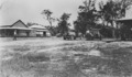
Local store and post office agency on the Bruce Highway
|
|||||||||||||||

Bororen
Location in Queensland
|
|||||||||||||||
| Population | 399 (2021 census) | ||||||||||||||
| • Density | 1.2058/km2 (3.123/sq mi) | ||||||||||||||
| Postcode(s) | 4678 | ||||||||||||||
| Area | 330.9 km2 (127.8 sq mi) | ||||||||||||||
| Time zone | AEST (UTC+10:00) | ||||||||||||||
| Location |
|
||||||||||||||
| LGA(s) | Gladstone Region | ||||||||||||||
| State electorate(s) | Burnett | ||||||||||||||
| Federal Division(s) | Flynn | ||||||||||||||
|
|||||||||||||||
Bororen is a small rural town in Queensland, Australia. It is also a local area within the Gladstone Region. In 2021, about 399 people lived in Bororen.
Contents
Where is Bororen?
Bororen is located in the middle of its local area. The main road, the Bruce Highway, goes right through the town. It comes from Miriam Vale in the south-east and continues north towards Foreshores.
The North Coast railway line also runs through Bororen. There is a train station in the town called Bororen railway station. The railway line follows the same path as the highway, coming from Miriam Vale and heading north to Foreshores.
Boondilla Neighbourhood
Boondilla is a small neighbourhood located in the north-west part of the Bororen area.
Bororen's Past
The name Bororen comes from an Aboriginal word. It means old man kangaroo.
Early Services
- The Bororen Post Office first opened on 2 June 1898. Before that, a smaller "receiving office" had been open since October 1897.
- Bororen Provisional School started on 22 January 1900. It became a State School in 1909.
- Another school, Turkey Road State School, opened in 1921 but closed on 24 May 1931.
Churches and Memorials
- The Bororen Anglican Church opened on 2 July 1931. It closed in 2015, and the building was later moved.
- The Bororen Presbyterian Church opened on Sunday 21 October 1923. This building has since been taken down.
- Around 1995, a special war memorial was put up on the Bruce Highway in Bororen. It remembers the brave men and women who served in World War I and World War II.
Learning in Bororen

Bororen State School is a government primary school for students from Prep to Year 6. It teaches both boys and girls. The school is located at 1 Kent Street. In 2017, the school had 37 students. In 2018, there were 31 students.
There are no high schools in Bororen itself. Students who want to continue their education after primary school can go to Miriam Vale State School. This school teaches up to Year 10. For students wanting to complete Year 12, the nearest high school is Tannum Sands State High School in Tannum Sands.
Images for kids
-
A street scene in Bororen around 1930.
