
Miriam Vale facts for kids
Quick facts for kids Miriam ValeQueensland |
|||||||||||||||
|---|---|---|---|---|---|---|---|---|---|---|---|---|---|---|---|
,_Miriam_Vale,_Queensland,_2016_01.jpg)
Blomfield Street (main street looking south-east), 2016
|
|||||||||||||||

Miriam Vale
Location in Queensland
|
|||||||||||||||
| Population | 493 (2021 census) | ||||||||||||||
| • Density | 11.281/km2 (29.22/sq mi) | ||||||||||||||
| Postcode(s) | 4677 | ||||||||||||||
| Area | 43.7 km2 (16.9 sq mi) | ||||||||||||||
| Time zone | AEST (UTC+10:00) | ||||||||||||||
| Location |
|
||||||||||||||
| LGA(s) | Gladstone Region | ||||||||||||||
| State electorate(s) | Burnett | ||||||||||||||
| Federal Division(s) | Flynn | ||||||||||||||
|
|||||||||||||||
Miriam Vale is a small, friendly town located in the Gladstone Region of Queensland, Australia. It's a rural area, meaning it's surrounded by nature and open spaces. In 2021, about 493 people called Miriam Vale home.
Contents
Where is Miriam Vale?
Miriam Vale is found right on the Bruce Highway, a major road in Queensland. It's about 464 kilometers (288 miles) north of Brisbane, which is Queensland's capital city. You can also find it about 170 kilometers (106 miles) south of Rockhampton.
What Miriam Vale is Known For
Miriam Vale is famous for its cattle farms. It also has a history of timber production and dairy farming. Today, tourism is becoming more important. The town is a great starting point for visiting popular tourist spots like Agnes Water and the Town of 1770.
Years ago, signs welcoming people to Miriam Vale mentioned "Cattle, Tobacco, Timber and Dairy." The tobacco farms stopped in the late 1970s, and dairy farming ended in the 1990s.
A Look at Miriam Vale's Past

The land around Miriam Vale has a long history with the Gureng Gureng people. Their language region covers a wide area, including towns like Bundaberg and Gin Gin.
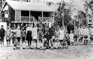
The Miriam Vale Post Office first opened its doors on April 1, 1877. The Miriam Vale State School started as a provisional school in March 1897 and became a full State School in July 1897.
St Mary's Anglican Church was built in 1912. Later, a new church replaced it around 1975. The Miriam Vale War Memorial was officially opened in 1921 to remember those who served. St Peter Chanel Catholic Church also opened in September 1954.
Timber Industry History
The timber industry has been important in Miriam Vale since the late 1800s. Early timber cutters worked in the Bobby Range, cutting down hoop pine trees. They even used special chutes to slide logs down the mountain to waiting wagons. Some of these old chutes can still be found today.
There were many timber mills in the area, but most of them closed down later in the 20th century.
Dairy Industry History

The dairy industry was a big part of Miriam Vale's past. A huge fig tree near the railway station was a central spot where farmers dropped off their milk in "cream cans." This milk was then taken to the Port Curtis Dairy in Gladstone. In the 1950s, farmers would separate cream on their farms and bring it to town. Back then, there wasn't much refrigeration, so cream was sold based on how fresh it was!
Racing and Rallies
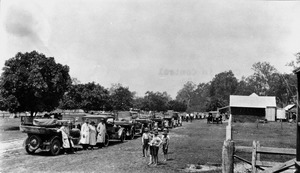
In 1924, a car rally passed through Miriam Vale. The road between Miriam Vale and Gin Gin was known as one of the roughest parts of the rally! There are also signs of an old speedway track from the 1970s and some old horse race tracks in the area.
Population Changes
The number of people living in Miriam Vale has changed over the years:
- In 2006, there were 361 people.
- In 2011, the population grew to 422 people.
- In 2016, it reached 512 people.
- In 2021, the population was 493 people.
Places of Interest
Miriam Vale has some special places that are listed for their heritage:
- The Miriam Vale War Memorial on Blomfield Street.
- The Big Fig tree on Station Street.
Schools in Miriam Vale

Miriam Vale State School is a government school for students from Prep (the first year of school) up to Year 10. It's located at 15 Roe Street. In 2023, the school had 129 students.
For students who want to continue their high school education beyond Year 10, they usually go to Tannum Sands State High School in Tannum Sands.
Community Services


The Miriam Vale Library is a great place to find books and information, located at 41 Blomfield Street. The Gladstone Regional Council also has an office in town.
The local branch of the Queensland Country Women's Association (QCWA) meets at their hall on Blomfield Street. This group helps women in rural areas.
You can also find St Peter Chanel Catholic Church on the Bruce Highway and St Mary's Anglican Church on Larson Street.
Fun Things to Do
Miriam Vale has a nine-hole golf course with small greens and beautiful gum trees. It's a great place to enjoy a game. As mentioned, Miriam Vale is also a gateway to the stunning Coral Coast, including Agnes Water and 1770, which are popular for their beaches and outdoor activities. The main street of Miriam Vale has the historic Miriam Vale Cafe and a park that's friendly for kids and dogs.
Getting Around
Miriam Vale is on the North Coast railway line and has its own train station, Miriam Vale railway station. This means you can travel to and from Miriam Vale by train.
| Long Distance Train Services | ||||
|---|---|---|---|---|
| Coming From | Train Service | Going To | ||
| Bundaberg | The Sunlander | Gladstone | ||
| Bundaberg | Electric Tilt Train | Gladstone | ||
| Bundaberg | Spirit of the Outback | Gladstone | ||
