
Bräcke facts for kids
Quick facts for kids
Bräcke
|
|
|---|---|

Central Bräcke
|
|

Bräcke
Location in Jämtland

Bräcke
Location in Sweden
|
|
| Country | Sweden |
| Province | Jämtland |
| County | Jämtland County |
| Municipality | Bräcke Municipality |
| Area | |
| • Total | 2.0 km2 (0.8 sq mi) |
| Population
(31 December 2010)
|
|
| • Total | 1,651 |
| • Density | 825/km2 (2,140/sq mi) |
| Time zone | UTC+1 (CET) |
| • Summer (DST) | UTC+2 (CEST) |
Bräcke is a small town in Jämtland County, Sweden. It is the main town of Bräcke Municipality. In 2010, about 1,651 people lived there.
Bräcke is located right next to a beautiful lake called Revsundssjön. It is about 70 kilometers (43 miles) southeast of Östersund, a larger city.
The railway has been very important for Bräcke's growth. The town is on the Central Line railway. It is also where the Main Line Through Upper Norrland begins. Major roads like European route E14 pass through Bräcke. Another road, Länsväg 323, starts here and goes towards Kälarne.
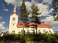
Bräcke Church, known as Bräcke kyrka, was built in the summer of 1859. It was designed by Abraham Rafael Ulric Pettersson. The outside of the church is covered with white wooden panels. Inside, the ceiling has a thin wooden arch. The painting behind the altar was made in 1926 by Karl Tirén, an artist from Stockholm. The church tower holds two bells. The smaller bell was made in 1778, and the larger one in 1859.
Bräcke's Climate
Bräcke has a subarctic climate. This means it has long, cold winters and short, cool summers. The town is on a high plateau, which is a flat area of land higher than the land around it. This location is between the coast and the mountains of Norrland.
Because of this, the weather can change a lot. Sometimes, it can even get frosty in the summer! The average temperature for the whole year is usually just above 2 degrees Celsius (36 degrees Fahrenheit). Bräcke is colder than nearby Torpshammar because it is higher up.
Bräcke is also in a "rain shadow." This means the Scandinavian Mountains block most of the rain and snow. So, the amount of snow in winter is usually not too deep.
| Climate data for Hunge, 20 km west of Bräcke; (2002–2020 averages; extremes since 1961) | |||||||||||||
|---|---|---|---|---|---|---|---|---|---|---|---|---|---|
| Month | Jan | Feb | Mar | Apr | May | Jun | Jul | Aug | Sep | Oct | Nov | Dec | Year |
| Record high °C (°F) | 9.5 (49.1) |
9.6 (49.3) |
14.9 (58.8) |
21.4 (70.5) |
26.6 (79.9) |
30.4 (86.7) |
30.6 (87.1) |
31.1 (88.0) |
23.8 (74.8) |
18.9 (66.0) |
12.7 (54.9) |
8.9 (48.0) |
31.1 (88.0) |
| Mean maximum °C (°F) | 4.2 (39.6) |
4.9 (40.8) |
8.7 (47.7) |
15.6 (60.1) |
22.6 (72.7) |
25.2 (77.4) |
26.7 (80.1) |
24.7 (76.5) |
19.7 (67.5) |
12.8 (55.0) |
7.7 (45.9) |
5.1 (41.2) |
28.0 (82.4) |
| Mean daily maximum °C (°F) | −3.5 (25.7) |
−2.3 (27.9) |
1.8 (35.2) |
7.7 (45.9) |
13.4 (56.1) |
17.6 (63.7) |
20.3 (68.5) |
18.4 (65.1) |
13.4 (56.1) |
6.4 (43.5) |
1.0 (33.8) |
−2.0 (28.4) |
7.7 (45.8) |
| Daily mean °C (°F) | −8.0 (17.6) |
−7.1 (19.2) |
−3.6 (25.5) |
2.3 (36.1) |
7.6 (45.7) |
12.1 (53.8) |
14.8 (58.6) |
13.3 (55.9) |
8.8 (47.8) |
2.8 (37.0) |
−2.4 (27.7) |
−6.2 (20.8) |
2.9 (37.1) |
| Mean daily minimum °C (°F) | −12.5 (9.5) |
−11.8 (10.8) |
−8.9 (16.0) |
−3.2 (26.2) |
1.8 (35.2) |
6.6 (43.9) |
9.3 (48.7) |
8.2 (46.8) |
4.2 (39.6) |
−0.8 (30.6) |
−5.7 (21.7) |
−10.3 (13.5) |
−1.9 (28.5) |
| Mean minimum °C (°F) | −26.9 (−16.4) |
−26.7 (−16.1) |
−23.4 (−10.1) |
−11.8 (10.8) |
−5.2 (22.6) |
0.0 (32.0) |
2.4 (36.3) |
0.9 (33.6) |
−2.7 (27.1) |
−9.4 (15.1) |
−17.0 (1.4) |
−23.3 (−9.9) |
−30.8 (−23.4) |
| Record low °C (°F) | −42.1 (−43.8) |
−38.1 (−36.6) |
−35.0 (−31.0) |
−21.9 (−7.4) |
−12.2 (10.0) |
−2.8 (27.0) |
−2.1 (28.2) |
−1.6 (29.1) |
−7.4 (18.7) |
−20.5 (−4.9) |
−28.4 (−19.1) |
−40.1 (−40.2) |
−42.1 (−43.8) |
| Average precipitation mm (inches) | 34.1 (1.34) |
21.9 (0.86) |
23.5 (0.93) |
24.5 (0.96) |
48.2 (1.90) |
66.9 (2.63) |
81.5 (3.21) |
73.6 (2.90) |
53.5 (2.11) |
45.5 (1.79) |
36.7 (1.44) |
38.4 (1.51) |
548.3 (21.58) |
| Source 1: SMHI Open Data | |||||||||||||
| Source 2: SMHI Open Data | |||||||||||||
Images for kids
-
Bräcke Church

See also
 In Spanish: Bräcke para niños
