Bradley, Arkansas facts for kids
Quick facts for kids
Bradley, Arkansas
|
|
|---|---|

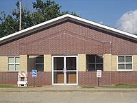
Bradley City Hall
|
|

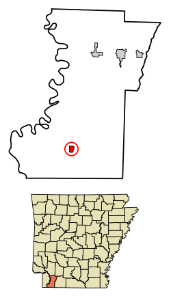
Location in Lafayette County, Arkansas
|
|
| Country | United States |
| State | Arkansas |
| County | Lafayette |
| Area | |
| • Total | 0.91 sq mi (2.36 km2) |
| • Land | 0.91 sq mi (2.36 km2) |
| • Water | 0.00 sq mi (0.00 km2) |
| Elevation | 259 ft (79 m) |
| Population
(2020)
|
|
| • Total | 405 |
| • Density | 443.59/sq mi (171.30/km2) |
| Time zone | UTC−06:00 (Central (CST)) |
| • Summer (DST) | UTC−05:00 (CDT) |
| ZIP Code |
71826
|
| Area code(s) | 870 |
| FIPS code | 05-08290 |
| GNIS feature ID | 2403911 |

Bradley is a small and friendly city located in Lafayette County, Arkansas, in the United States. It's a place where people live and work together. In 2020, about 405 people called Bradley home.
Contents
Where is Bradley Located?
Bradley is in the southern part of Lafayette County. You can find it where two main roads meet: Arkansas Highway 29 and Arkansas Highway 160.
Getting Around Bradley
- Highway 29 goes north about 19 miles (31 km) to a town called Lewisville.
- If you go south on Highway 29 for about 6 miles (10 km), you'll reach the border of Louisiana.
- Highway 160 goes east from Bradley about 7 miles (11 km) to a community called State Line.
- Going west on Highway 160 for about 15 miles (24 km) will take you near Interstate 49.
How Big is Bradley?
The city of Bradley covers a total area of about 0.91 square miles (2.36 square kilometers). All of this area is land.
Who Lives in Bradley?
The number of people living in Bradley has changed over the years. Here's a quick look at how the population has grown and shrunk:
| Historical population | |||
|---|---|---|---|
| Census | Pop. | %± | |
| 1910 | 123 | — | |
| 1920 | 290 | 135.8% | |
| 1930 | 363 | 25.2% | |
| 1940 | 409 | 12.7% | |
| 1950 | 444 | 8.6% | |
| 1960 | 712 | 60.4% | |
| 1970 | 706 | −0.8% | |
| 1980 | 790 | 11.9% | |
| 1990 | 585 | −25.9% | |
| 2000 | 563 | −3.8% | |
| 2010 | 628 | 11.5% | |
| 2020 | 405 | −35.5% | |
| U.S. Decennial Census | |||
What the 2020 Census Shows
The 2020 Census helps us understand the different groups of people living in Bradley.
| Race / Ethnicity (NH = Non-Hispanic) | Pop 2000 | Pop 2010 | Pop 2020 | % 2000 | % 2010 | % 2020 |
|---|---|---|---|---|---|---|
| White alone (NH) | 261 | 263 | 165 | 46.36% | 41.88% | 40.74% |
| Black or African American alone (NH) | 291 | 353 | 222 | 51.69% | 56.21% | 54.81% |
| Native American or Alaska Native alone (NH) | 0 | 1 | 0 | 0.00% | 0.16% | 0.00% |
| Asian alone (NH) | 2 | 1 | 1 | 0.36% | 0.16% | 0.25% |
| Pacific Islander alone (NH) | 0 | 0 | 0 | 0.00% | 0.00% | 0.00% |
| Other race alone (NH) | 0 | 0 | 0 | 0.00% | 0.00% | 0.00% |
| Mixed race or Multiracial (NH) | 5 | 1 | 8 | 0.89% | 0.16% | 1.98% |
| Hispanic or Latino (any race) | 4 | 9 | 9 | 0.71% | 1.43% | 2.22% |
| Total | 563 | 628 | 405 | 100.00% | 100.00% | 100.00% |
In 2000, there were 563 people living in Bradley. About 46% were White and 52% were Black or African American. A small number of people were Asian or from two or more races.
The average household had about 2.5 people. Many households had children under 18. The median age in the city was 31 years old. This means half the people were younger than 31 and half were older.
Education in Bradley
Students in Bradley attend public schools that are part of the Emerson-Taylor-Bradley School District.
Schools in Bradley
- Bradley Elementary School
- Bradley High School
The school's mascot is the Bear. The school colors are purple and gold. The former Bradley School District joined with the Emerson-Taylor district in 2013.
Highways in Bradley
The city is connected by two main highways:
See also
 In Spanish: Bradley (Arkansas) para niños
 | Victor J. Glover |
 | Yvonne Cagle |
 | Jeanette Epps |
 | Bernard A. Harris Jr. |

