Brayton, Iowa facts for kids
Quick facts for kids
Brayton, Iowa
|
|
|---|---|
 |
|

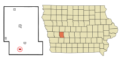
Location of Brayton, Iowa
|
|
| Country | |
| State | |
| County | Audubon |
| Area | |
| • Total | 0.43 sq mi (1.13 km2) |
| • Land | 0.43 sq mi (1.13 km2) |
| • Water | 0.00 sq mi (0.00 km2) |
| Elevation | 1,207 ft (368 m) |
| Population
(2020)
|
|
| • Total | 143 |
| • Density | 328.74/sq mi (127.05/km2) |
| Time zone | UTC-6 (Central (CST)) |
| • Summer (DST) | UTC-5 (CDT) |
| ZIP code |
50042
|
| Area code(s) | 712 |
| FIPS code | 19-08200 |
| GNIS feature ID | 0454809 |
Brayton is a small city in Audubon County, Iowa, in the United States. It is located along the East Nishnabotna River. In 2020, about 143 people lived there.
Contents
A Look Back in Time
Brayton was founded in 1878. It was named after a railroad employee. The first school in Brayton opened its doors in 1896. This helped children in the area get an education.
Where is Brayton Located?
Brayton is located at these coordinates: 41°32′43″N 94°55′33″W / 41.54528°N 94.92583°W. This means it is at 41.545283 degrees north latitude and -94.925865 degrees west longitude.
The United States Census Bureau says that Brayton covers about 0.62 square miles (1.6 square kilometers). All of this area is land.
Who Lives in Brayton?
| Historical populations | ||
|---|---|---|
| Year | Pop. | ±% |
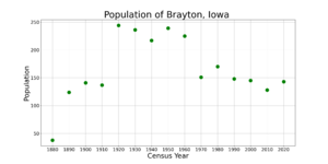
| 1880 | 38 | — |
| 1890 | 124 | +226.3% |
| 1900 | 141 | +13.7% |
| 1910 | 137 | −2.8% |
| 1920 | 244 | +78.1% |
| 1930 | 236 | −3.3% |
| 1940 | 217 | −8.1% |
| 1950 | 239 | +10.1% |
| 1960 | 225 | −5.9% |
| 1970 | 151 | −32.9% |
| 1980 | 170 | +12.6% |
| 1990 | 148 | −12.9% |
| 2000 | 145 | −2.0% |
| 2010 | 128 | −11.7% |
| 2020 | 143 | +11.7% |
| Source: and Iowa Data Center Source: |
||
Population in 2020
The census in 2020 counted 143 people living in Brayton. There were 60 households and 39 families. The population density was about 329 people per square mile (127 people per square kilometer). There were 66 homes in the city.
Most people in Brayton were White. A small number of people were from two or more races. Less than 1% of the population was Hispanic or Latino.
- About 40% of households had children under 18 living with them.
- About 33% of households were married couples.
- About 35% of all households were not families.
- About 31% of households had only one person living there.
- About 10% of households had someone 65 years old or older living alone.
The average age in Brayton was 36.5 years. About 31% of residents were under 20 years old. About 11% were 65 years or older. The population was almost evenly split between males (50.3%) and females (49.7%).
Population in 2010
The census in 2010 counted 128 people living in Brayton. There were 62 households and 33 families. The population density was about 206 people per square mile (80 people per square kilometer). There were 70 homes in the city.
Most people in Brayton were White. A small number of people were from two or more races. Less than 1% of the population was Hispanic or Latino.
- About 21% of households had children under 18 living with them.
- About 45% of households were married couples.
- About 47% of all households were not families.
- About 40% of all households had only one person living there.
- About 14% of households had someone 65 years old or older living alone.
The average age in Brayton was 43 years. About 20% of residents were under 18 years old. About 21% were 65 years or older. The population was about 53% male and 47% female.
Schools in Brayton
Brayton is part of the Exira–Elk Horn–Kimballton Community School District.
Brayton's local schools joined with the Exira Community School District around the late 1950s or early 1960s. Later, on July 1, 2014, the Exira district combined with the Elk Horn–Kimballton Community School District. This created the new Exira–Elk Horn–Kimballton district that serves the area today.
See also
 In Spanish: Brayton (Iowa) para niños
 | Georgia Louise Harris Brown |
 | Julian Abele |
 | Norma Merrick Sklarek |
 | William Sidney Pittman |


