Breda, Iowa facts for kids
Quick facts for kids
Breda, Iowa
|
|
|---|---|
 |
|
 |
|
| Country | |
| State | |
| County | Carroll County |
| Area | |
| • Total | 0.74 sq mi (1.92 km2) |
| • Land | 0.74 sq mi (1.92 km2) |
| • Water | 0.00 sq mi (0.00 km2) |
| Elevation | 1,362 ft (415 m) |
| Population
(2020)
|
|
| • Total | 500 |
| • Density | 676.59/sq mi (261.08/km2) |
| Time zone | UTC-6 (Central (CST)) |
| • Summer (DST) | UTC-5 (CDT) |
| ZIP code |
51436
|
| Area code(s) | 712 |
| FIPS code | 19-08290 |
| GNIS feature ID | 2393408 |
Breda is a small city located in Carroll County, Iowa, in the United States. It's a friendly place with a population of 500 people, according to the 2020 census.
Contents
The Story of Breda: How it Started
Breda began its journey in 1877. This was around the time the Chicago and North Western railroad built a new line through the area. A settler who came from the city of Breda in the Netherlands decided to name this new place after their hometown.
Where is Breda? (Geography)
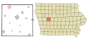
Breda is located in Iowa. The city covers a total area of about 0.74 square miles (1.92 square kilometers). All of this area is land, meaning there are no large lakes or rivers within the city limits.
Who Lives in Breda? (Population Facts)
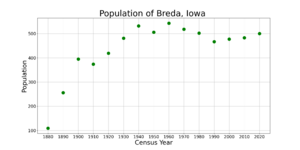
| Historical population | ||
|---|---|---|
| Year | Pop. | ±% |
| 1880 | 109 | — |
| 1890 | 256 | +134.9% |
| 1900 | 395 | +54.3% |
| 1910 | 374 | −5.3% |
| 1920 | 419 | +12.0% |
| 1930 | 481 | +14.8% |
| 1940 | 532 | +10.6% |
| 1950 | 506 | −4.9% |
| 1960 | 543 | +7.3% |
| 1970 | 518 | −4.6% |
| 1980 | 502 | −3.1% |
| 1990 | 467 | −7.0% |
| 2000 | 477 | +2.1% |
| 2010 | 483 | +1.3% |
| 2020 | 500 | +3.5% |
| Source: and Iowa Data Center Source: |
||
The word "demographics" helps us understand who lives in a place. It looks at things like how many people there are, their ages, and how many households exist.
Breda's Population in 2020
In 2020, the city of Breda had 500 people living there. There were 214 households, which means 214 different homes or groups of people living together. About 140 of these were families.
Most people in Breda (97.6%) were White. A small number of people were from other backgrounds. About 1% of the population identified as Hispanic or Latino.
- Young People: About 26.4% of Breda's residents were under 20 years old.
- Adults: The largest group, about 30.6%, were between 25 and 44 years old.
- Seniors: About 14.4% of the people were 65 years old or older.
The average age in Breda in 2020 was 36 years old. Slightly more males lived in the city (53.8%) than females (46.2%).
Breda's Population in 2010
Ten years earlier, in 2010, Breda had 483 people. There were 211 households. The population density was about 652.7 people per square mile.
Most residents (98.8%) were White. A small percentage were African American, Asian, or from two or more races.
- Young People: About 25.3% of residents were under 18 years old.
- Adults: About 27.3% were between 25 and 44 years old.
- Seniors: About 16.8% were 65 years old or older.
The average age in 2010 was 37.6 years. The number of males and females was almost equal, with 50.5% male and 49.5% female.
Learning in Breda (Education)
Students in Breda attend schools that are part of the Carroll Community School District. These schools are located in the nearby city of Carroll.
For students who attend Catholic schools, the Kuemper Catholic School System in Carroll is also an option.
History of Catholic Schools in Breda
Breda used to have its own Catholic schools. The first one opened way back in 1884.
- St. Bernard Grade School started in 1903.
- St. Bernard High School opened in 1927 in the same building.
- The high school got its own building in 1951.
In 1979, St. Bernard High School joined with Kuemper Catholic High School. The old high school building became the new St. Bernard Elementary school. The original elementary building was torn down in 1980.
Later, in 1983, St. Bernard Elementary merged with other Catholic schools from nearby towns to form Christ the King School. This school, along with Holy Trinity Catholic grade school, became part of the Kuemper Catholic System in 2003.
Today, the former St. Bernard High School building is owned by St. Bernard Church. Part of it has been renovated into the Mary Nieland Center, which is used as a community center. Other parts of the old school are now used for different community and fun activities.
See also
 In Spanish: Breda (Iowa) para niños
 | Calvin Brent |
 | Walter T. Bailey |
 | Martha Cassell Thompson |
 | Alberta Jeannette Cassell |


