
Brewer Island facts for kids

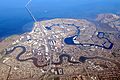
USGS aerial imagery of Brewer Island
|
|

Brewer Island
Location in San Francisco Bay Area

Brewer Island
Location in California

Brewer Island
Location in the United States
|
|
| Geography | |
|---|---|
| Location | Northern California |
| Coordinates | 37°33′25″N 122°15′50″W / 37.55694°N 122.26389°W |
| Adjacent bodies of water | San Francisco Bay |
| Highest elevation | 7 ft (2.1 m) |
| Administration | |
|
United States
|
|
| State | |
| County | San Mateo |
Brewer Island is a unique island located in the beautiful San Francisco Bay in Northern California. What makes it so special? It's the land where the modern city of Foster City was built!
This island is part of San Mateo County. In 1981, the United States Geological Survey (USGS) measured its elevation as about 7 feet (2.1 meters) above sea level.
Contents
Where is Brewer Island Located?
Brewer Island sits right in the middle of the San Francisco Bay. It's a key part of the landscape in San Mateo County. Its exact location can be found using coordinates: 37°33′25″N 122°15′50″W / 37.55694°N 122.26389°W.
From Island to City: The Story of Foster City
Brewer Island wasn't always a bustling city. For many years, it was mostly marshland and open space. But over time, people saw its potential. They began to imagine a new community built right on the bay.
How Foster City Was Created
The idea to build a city on Brewer Island came from a man named T. Jack Foster. He bought the land in the 1950s. His dream was to create a planned community. This meant everything would be designed from scratch.
To make this dream happen, a lot of work was needed. The land had to be raised and made stable. This was done by adding sand and dirt. This process is called "land reclamation." It turned the marshy island into solid ground for buildings and homes.
A Modern Bayfront Community
Today, Foster City is a thriving place. It's known for its lagoons and canals. These waterways are perfect for boating and other water sports. The city has many parks, schools, and businesses. It's a great example of how people can build a city in a challenging environment.
The transformation of Brewer Island into Foster City is a big achievement. It shows how engineering and planning can create new living spaces. It also highlights how people can adapt to their environment.
Images for kids
-
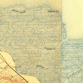
Current area in a 1899 USGS survey map.
-
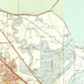
1949 USGS survey map.
-
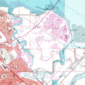
1956 USGS survey map.
-
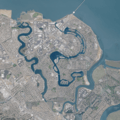
Current state of the island, with USGS aerial imagery.
-
Foster City in 2018


