Brick Center, Colorado facts for kids
Quick facts for kids
Brick Center, Colorado
|
|
|---|---|

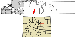
Location of the Brick Center CDP in Arapahoe County, Colorado.
|
|
| Country | |
| State | |
| County | Arapahoe County |
| Government | |
| • Type | unincorporated community |
| Area | |
| • Total | 5.798 sq mi (15.016 km2) |
| • Land | 5.778 sq mi (14.964 km2) |
| • Water | 0.020 sq mi (0.052 km2) |
| Elevation | 5,820 ft (1,774 m) |
| Population
(2020)
|
|
| • Total | 105 |
| • Density | 18.11/sq mi (6.99/km2) |
| Time zone | UTC-7 (MST) |
| • Summer (DST) | UTC-6 (MDT) |
| ZIP Code |
Bennett 80102
|
| Area codes | 303 & 720 |
| GNIS feature | Brick Center CDP |
Brick Center is a small community in Arapahoe County, Colorado, United States. It is not an official town but is recognized as a census-designated place (CDP). This means it's an area the government defines for collecting information about people.
Brick Center is part of the larger Denver–Aurora–Lakewood, CO Metropolitan Statistical Area. In 2020, about 105 people lived there. The local Bennett post office (with Zip code 80102) serves the area.
Contents
Understanding Brick Center's Location
This section explains where Brick Center is found and its size.
How Big is Brick Center?
The Brick Center CDP covers an area of about 15 square kilometers (or 5.8 square miles). Most of this area is land. Only a small part, about 0.052 square kilometers (or 0.020 square miles), is water.
Who Lives in Brick Center?
This section looks at the population of Brick Center over time. Studying populations is called demographics.
Population Changes Over Time
The United States Census Bureau first officially counted Brick Center as a CDP for the United States Census 2010. A census is a count of all the people living in a country.
Here's how the population has changed:
| Brick Center CDP, Colorado | ||
|---|---|---|
| Year | Pop. | ±% |
| 2010 | 107 | — |
| 2020 | 105 | −1.9% |
| Source: United States Census Bureau | ||
See also
 In Spanish: Brick Center para niños
 | Calvin Brent |
 | Walter T. Bailey |
 | Martha Cassell Thompson |
 | Alberta Jeannette Cassell |


